
Surveyors and GIS professionals have the highest standards when it comes to their tools and their trade. It’s no wonder that many surveyors are turning to drones for their mapping and 3D modeling needs. Surveying drones consistently achieve results that meet survey-grade accuracy standards, and in comparison with traditional surveying techniques, drones drastically reduce the time, cost, and effort required.
Surveying with drones is more complicated than snapping a few photographs from above. There are several steps required, from preparing ground control points, to mission planning, to processing the images you capture with surveying software.
Oftentimes surveyors are commissioned to produce high-resolution orthomosaics constructed with photogrammetry techniques, or 3D models created with oblique cameras and 3D surveying techniques.
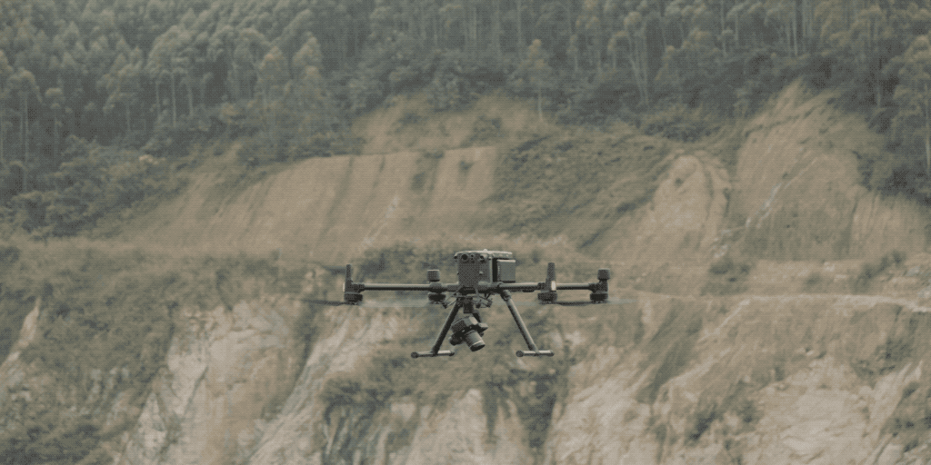
With DJI’s latest flagship surveying combo, the Matrice 300 RTK (M300 RTK) and the Zenmuse P1 payload, surveyors have at their fingertips the ultimate surveying solution in terms of accuracy and efficiency. Thanks to the P1’s Smart Oblique Capture (SOC) feature, surveyors can now capture and create 3D models of their targets more efficiently than ever before.
What is oblique photography?
Within drone surveying, a technique that has seen success in 3D modeling is the use of oblique photogrammetry, where images are captured by several lenses. These multiple lenses are mounted together in an array with fixed axis angles. The resulting images reveal details that are sometimes missed when only capturing vertical photographs, such as features occluded by vegetation or tall structures.
Oblique camera systems traditionally use a mechanical rig with five cameras in fixed positions in a cross configuration; one camera in the center is surrounded by four other cameras, in front, behind, left and right, equally distanced at 90-degree intervals. This system places the central camera at an oblique angle where the ‘nadir’ angle (the point directly below the camera at ground level) is at a known, fixed point in the image.
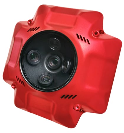 An oblique camera payload
Benefits of oblique photography
The requirements for accurate 3D models are ever-increasing. For example, within urban mapping, 3D models are used for space management, energy requirement analysis, traffic and pollution monitoring, and disaster management. In surveying, an accurate 3D model can identify potential problems early in a project’s timeline.
When compared with vertical aerial photography, oblique photography has many benefits. While a vertical angle can help show the placement of features like buildings, streets, or open spaces in relation to each other, oblique aerial photos are better at giving perspective of the appearance of features that rise from the ground like buildings, topography, foliage, etc in relation to the ground and horizon.
Some more benefits of oblique photography include:
- Images captured with an oblique camera reveal details that otherwise may have been obstructed in the vertical view by foliage or tall buildings.
- Oblique photography makes it easier to accurately determine the elevation of features, when compared with vertical aerial photographs
- As opposed to an orthographic setup, where the central camera looks directly down, the oblique system captures far more of the relative height data ahead of it. This also negates any lens distortion in all directions around the focal point, which the orthographic method could often suffer from.
- Using multiple shots at controlled intervals, the position and relative height information gathered from each dataset can be compared, contrasted, and then amalgamated to give the relative height information between elements in the target area, producing a map of both position and height data, which can be rendered as a 3D map of the area surveyed.
Limitations of oblique cameras
However, there are disadvantages associated with traditional oblique camera arrays. Due to the number of lenses, the rig can be very heavy and expensive. A heavier payload means shorter flight times and more time spent swapping drone batteries, especially for larger-scale surveying missions.
On the other hand, if attempting oblique photogrammetry or 3D modeling with a single camera, then five flights are required (Nadir, FBLR) which takes significantly longer. For some time a new, lighter, quicker, and more cost-effective solution has been searched for.
What is Smart Oblique Capture?
Smart Oblique Capture (SOC) is a new alternative process, exclusive to the P1 and the M300, that uses a single camera mounted on a gimbal to function as all five of the cameras in an oblique camera system. The P1 is a ‘traditional’ camera (not an oblique camera) with a single lens, but can produce the same results thanks to elegant software.
When drawing the mapping area out on the DJI Pilot app (during mission planning), SOC automatically divides the target surveying area out into different ‘sections’. These sections denote how many photo angles are captured in this area. For example, sections in the center of the surveying area get five photos, one at each angle (nadir, front, back, left, and right). Sections at the periphery of the surveying area require fewer photos.
With Smart Oblique Capture, because the photos in each “set” of shots are not taken simultaneously, the position data, drone speed, and gimbal direction are embedded into the metadata of each photo in order to compensate for the shift in position and perspective; similar to the mathematical calculations used to amalgamate the consecutive captures in an oblique camera array.
In this video, you will see that the dark green areas are only taking one side shot, purely for height data. The nadir shots are only captured in the yellow and light green areas and then at multiple points in the red designated target area, where the most information is required.
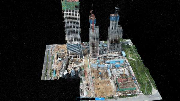
Once your survey is complete, you can utilize post-processing software, like DJI Terra, to collate all the data and produce the 3D models required; the SD card can simply be plugged into a laptop to import the images for processing.
Each dataset of shots (Nadir, FBLR) is compared to one another, where the nadir shots are used to create a top-down 2D map. The directional shots from each position are compared in order to designate relative height information for those elements on the 2D map.
Your surveying missions captured with the M300 RTK and P1 can be natively processed using DJI Terra, our all-in-one drone surveying software used to plan, visualize, process, and analyze aerial photography. The application allows the user to quickly render and visualize the data in real-time and reduces post-processing times. It creates detailed and accurate measurement results for high-resolution 2D orthomosaics and realistic, fully navigable, 3D model reconstructions.

Advantages of Smart Oblique Capture
- The P1 is one payload that replaces the need for a multi-camera oblique system. This reduces weight and increases maneuverability and flexibility of deployment; being attached to a drone, as opposed to being connected to the hull of a larger aircraft, is a major benefit.
- SOC reduces the number of unnecessary photos captured. This means there is no time wasted taking pictures at the periphery of the surveying target as well as less space and memory used, resulting in a quicker processing time.
- Interchangeable camera lenses on the P1 allow the swapping of lenses according to a project’s needs. This is not achievable with a traditional oblique camera.
- In addition to the M300’s RTK modules, SOC can take full advantage of post-processing kinematics. In situations where RTK is unavailable, PPK is available because mission files are stored with original GNSS observations and TimeStamps.MRK files.
Some more about the Zenmuse P1
The P1 is DJI’s flagship photogrammetry and surveying payload. With a 45 MP full-frame, low-noise, high-sensitivity sensor with interchangeable 24/35/50mm fixed-focus lenses on a 3-axis stabilized gimbal, this is our most powerful surveying camera to date. The P1 can take a photo every 0.7 seconds (with shutter speeds of up to 1/2000th of a second) and can cover 3 km2 in a single flight.
Read more about the P1’s features here.
The P1 is compatible with DJI’s Matrice 300 RTK, our latest commercial drone platform. Capable of 6 directional sensing and positioning, 55 minutes of flight time, and a 15km range, the M300 is a welcome new addition to any drone fleet.

Get ahead, get smart
By cutting down on the number of images taken, SOC effectively reduces the in-air time of a mission and, therefore, the total time of surveying and mapping. This has the added benefit of a subsequent 20%-50% reduction of post-processing time.
With the rise of drone use in surveying, mapping, and construction, there is a constant need for their utilization to become simpler and more economical, in terms of time and cost. Smart Oblique Capture is one such innovation that covers both.


-3.png?width=300&name=Insight%20blog%20featured%20image%201140X660%20(2)-3.png)