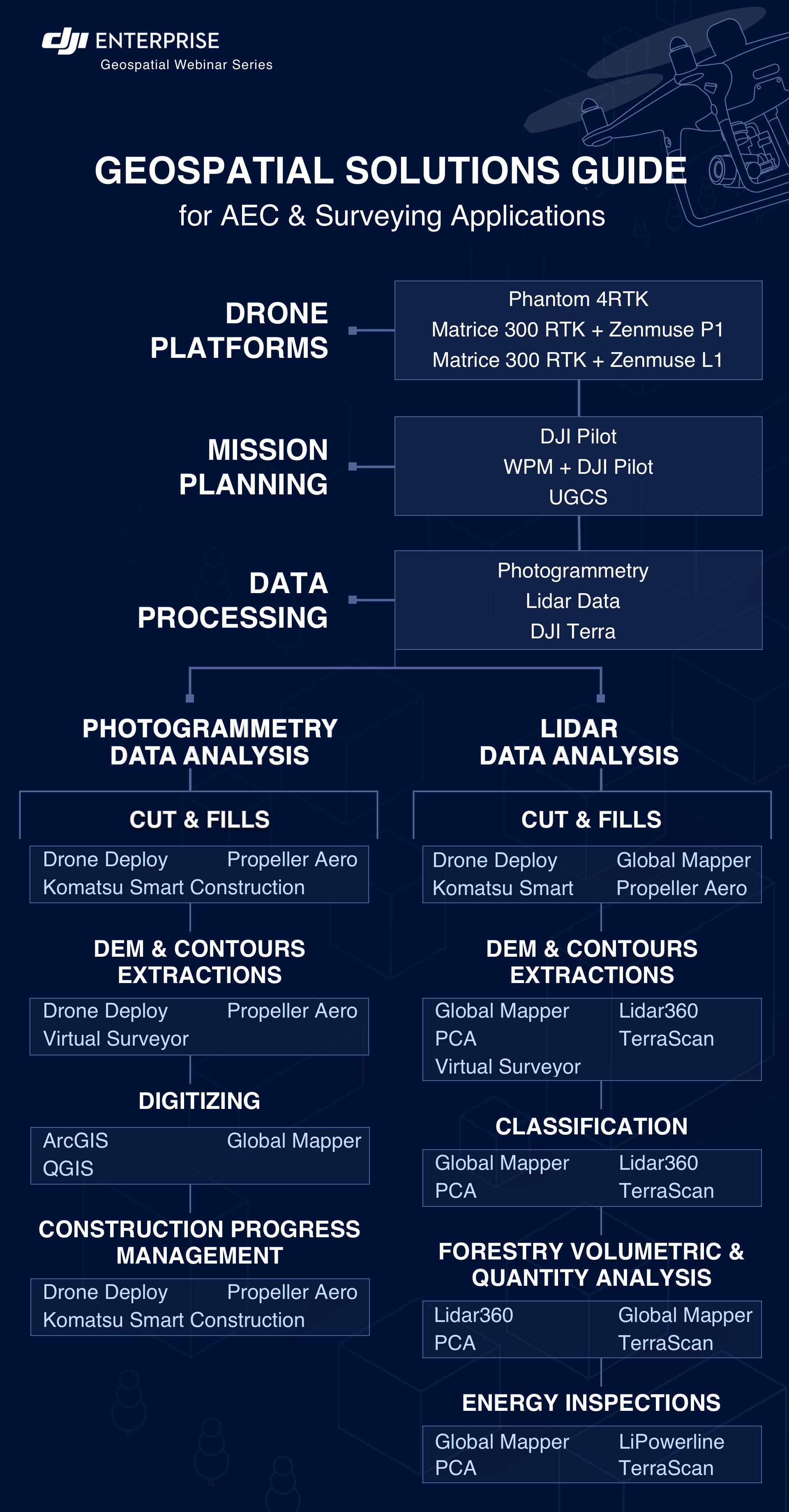
Drones have long since proven their value as powerful Geospatial tools. As DJI's surveying solutions continue to evolve, more and more professionals from the architecture, engineering, and construction industries are turning to drones to enhance workplace efficiency, safety, and ROI.
DJI is pleased to announce that in the month of July, we will be hosting a series of webinars together with our partners, where we dive deep into the latest UAV surveying solutions, software, and workflows.
Tune in to learn from industry experts about the following topics:
Browse the list below to learn more and to register.

To accommodate viewers from around the globe, we are offering each webinar twice at the following times:
Previous webinars:
Webinar recordings are available at the links below.
| Topic | Speaker | Company | Date |
|
GeoSpatial Introduction |
Simba Wang, Director of Geospatial Business & Solutions |
DJI |
July 1st |
|
DJI L1 Point Cloud Processing using TerraScan and TerraModeler |
Xabier Eraña & Arttu Soininen
|
TerraSolid |
July 6th |
|
DJI Enterprise Services For Your Geospatial Solutions |
Joyce Zhou Key Account Manager for NA |
DJI |
July 13th |
|
Standard Workflows for Surveyors and Construction Sites for Familiar Deliverables From Drones |
Shannon Hixon CEO |
Hixon |
July 15th |
|
Creating Contour Lines at Ground Level with L1 & P1 Data |
Tom Op ‘t Eyndt, Chief Executive Officer |
Virtual Surveyor |
July 20th |
|
A Digital Transformation of the Jobsite: Using drones to visualize and analyze construction projects |
Yoetzin Diaz & Bryce Satterly |
Komatsu |
July 22nd |
|
Introduction to Point Cloud Automata, one-step point cloud post-processing software for the Zenmuse L1 |
Wenhan Xie CTO |
Points2Model |
July 29th |
Blog
White Paper
Blog
We do not disclose your personal information to third parties in exchange for monetary consideration. Nevertheless, under certain U.S. state privacy laws, such as the California Consumer Privacy Act ("CCPA") and the Virginia Consumer Data Protection Act ("VCDPA"), disclosing personal information for personalized advertising purposes may be considered a "sale" or "sharing" of personal information, or processing for "targeted advertising" purposes. Residents of these U.S. states have the right to opt out of the "sale" or "sharing" of their personal information or the processing of their personal information for "targeted advertising." This opt-out right may vary by state, but we nevertheless offer a unified option for our U.S. customers to exercise this right.
If you want to opt out of the sale or sharing of your personal information or processing for targeted advertising, please deselect the "Marketing Cookies" checkbox through Cookie Preferences. Please note that you will need to opt out on each browser you use.
You can learn more about how we collect, use, and disclose your personal information, as well as other rights and choices you may have, by reviewing our Cookie Policy.
Copyright © 2026 DJI All Rights Reserved.
Feedback on web experience? Click here