
The Monarch butterfly’s annual migration is one of the world’s most fascinating natural phenomena, and is one of the longest and largest in the insect world, spanning more than 4,000 km.
The migration is a symbol of international cooperation among Canada, the United States, and Mexico, who work together to preserve the monarchs' route from southern Canada's Great Lakes Zone to central Mexico's Michoacán and State of Mexico, passing through the central-western plains of the United States.
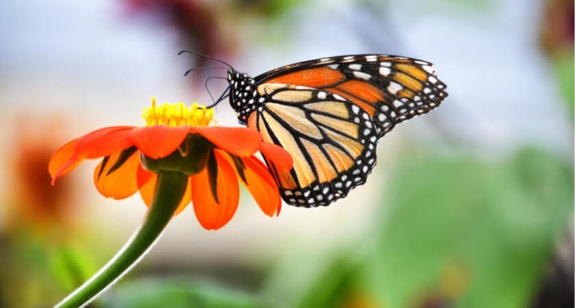
However, this migration is at risk of extinction due to environmental changes, habitat destruction, and deforestation that jeopardize the monarch’s breeding grounds.
For this reason, the Neovolvanic Axis Conservation Fund (FOCEN) an organization dedicated to preserve the habitats and forests where the monarchs hibernate, is searching for every means possible to protect and support this phenomenon. In a partnership with Cielito Drone and DJI Enterprise, they have turned to drones to collect vital forestry data in an effort to preserve these critical habitats.
About the Monarch’s migration and lifecycle:
The life cycle of a monarch butterfly typically lasts for a month, but the "Methuselah generation," which emerges in mid-August, is different. This generation delays its reproductive period and can live for up to 9 months, allowing it to travel south for two months, spend five months in Mexico, and then return north. These butterflies have never been to the location where they hibernate every year in Mexico but are guided by a unique radar within their species.
Vital ecosystem supporters
Throughout their lives, monarch butterflies play a crucial role within the ecosystem. As herbivores, they feed on milkweed plants during the initial stage of their life, and as important pollinators, they feed on flower nectar during their adult stage. During their migration, they promote the genetic diversity of flowering plants and contribute to human food security throughout North America by transporting pollen attached to their bodies.
Milkweed plants are essential to monarch butterflies, as they serve as the site for laying their eggs during the breeding season. In total, each female lays up to 400 eggs, which hatch after eight days into caterpillars with distinctive black, white, and yellow stripes. The caterpillars consume milkweed leaves and undergo metamorphosis, emerging as adult butterflies after two weeks.
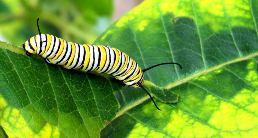 A monarch caterpillar enjoying a milkweed leaf
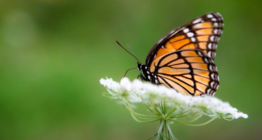 Monarch butterflies are essential pollinators in the various ecosystems and food crops they encounter on their migratory route throughout Canada, the United States, and Mexico.
The Oyamel fir and the Monarch’s endagered status
The monarch butterfly is currently categorized as endangered by the International Union for Conservation of Nature (IUCN), the largest source of information on the risk status of global biodiversity. This is due to a significant population decline of up to 72% in the last decade.
The monarch butterfly's decline is attributed to two main causes:
- Excessive use of pesticides and herbicides that kill both the butterflies and their milkweed habitat
- Illegal logging and deforestation of the forest areas in Mexico that serve as the monarch’s winter refuge
In addition to direct anthropogenic activities, climate change has caused a decrease in rainfall and an increase in temperature, weakening forest species and making them more susceptible to pests and diseases such as bark stripping insects.
In particular, the Oyamel fir, the Monarch’s preferred tree for their winter hibernation, is under threat from a mysterious phenomenon that causes the tree to turn white, lose its foliage, and die. If these trees continue to disappear, and actions aren’t taken to protect this vital habitat, the monarch butterfly migration phenomenon may be lost forever.
Monarch Butterfly Biosphere Reserve in Mexico
The Oyamel forests have been declared a Monarch Butterfly Biosphere Reserve and designated as a Natural World Heritage Site by UNESCO. The ejidos and communities, government authorities, and civil society are working together to protect the areas designated for the arrival of monarch butterflies. They have implemented permanent monitoring of the health status of the trees in the overwintering sites to ensure their preservation.
Limitations of traditional conservation techniques
Conventional forest monitoring techniques have been used in the Monarch Butterfly Biosphere Reserve since its creation. However, this involves ejidatarios and community members travelling long distances on foot, visually identifying changes in the trees. This method is inefficient and even dangerous in inhospitable terrain, and it is impossible to cover the entire area of interest in a single day.
Direct observation is also limited by the high density of trees, the number of branches, the height, and human vision. Furthermore, since diseased trees begin to die from the top of the canopy down, it is difficult to determine the health status of these majestic trees by foot.
According to data from Fondo de Conservación del Eje Neovolcánico A.C., phytosanitary monitoring teams only make six trips a year for early detection of forest pests and diseases within the core zone of the Biosphere Reserve. This is not sufficient to protect the forest from threats.
To address these challenges, it is urgent to evolve forest monitoring methods by adopting drones.
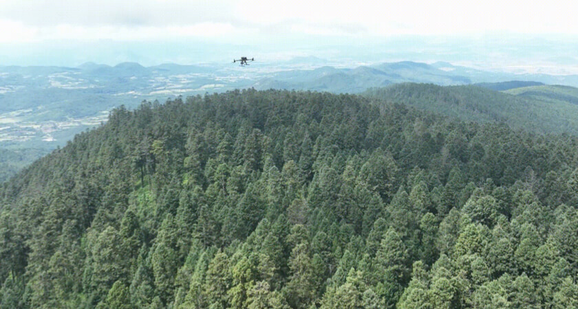 Matrice 300 RTK flying over the Monarch Butterfly Biosphere Reserve
Conservation drones
When the International Union for Conservation of Nature (IUCN) declared the monarch butterfly phenomenon endangered, DJI Enterprise, together with Cielito Drone and authorities of the Monarch Butterfly Biosphere Reserve, deployed a research project to determine the causes and level of damage to the ecosystem that houses the monarch butterflies in Mexico.
Drones offer many advantages over conventional forest inventory methods. Thanks to technological advancements, drones are becoming increasingly accessible and easy to control, allowing people who are not experts to safely and accurately execute flight missions regardless of the complexity of their study sites. By incorporating drones into forest monitoring activities, it will be possible to cover a larger area, obtain higher-resolution images, and detect changes in tree health that are difficult to see with the naked eye.
The power of multispectral
With multispectral monitoring tools and sensor technology such as LiDAR and photogrammetric cameras, it is possible to efficiently, quickly, and safely analyze ecosystems.
Cielito Drone utilized DJI Enterprise equipment, specifically the Mavic 3 Multispectral and the Matrice 300 RTK with the LiDAR L1 sensor, to conduct flights within the core zone of the reserve.
The Mavic 3 Multispectral has 45 megapixel multispectral bands, including green, red, red edge, and near-infrared, which allowed the team to identify areas with signs of forest decline early by calculating spectral indices used in vegetation monitoring. This data was crucial in detecting devitalized trees, which required emergency sanitation actions.
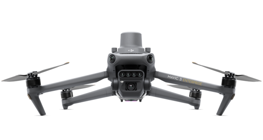 Mavic 3 Multispectral
Terrain Follow for elevation changes
During the flights, the drones covered a range of altitudes between 2,800 to 3,500 meters above sea level, which correspond to the distribution of Oyamel trees. The DJI Mavic 3's Terrain Follow feature enabled successful flights over the main basins where the monarch butterfly hibernates, maintaining a consistent height above the ground. This allowed for reliable and consistent data collection throughout the flight, despite the nearly 700-meter difference in altitude between the lowest and highest areas.
Precision aerial LiDAR
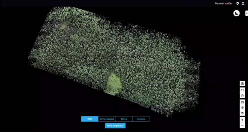
Additionally, the team used a Matrice 300 RTK equipped with a Zemuse L1 sensor (a LiDAR sensor) to obtain precise measurements of the height, crown diameter, and amount of biomass of trees at the sites where the monarch butterflies arrive. Despite the dense and complex forest environment within the reserve, the M300 and L1 provided a complete and user-friendly solution, capable of generating impressive three-dimensional models of the magnificent oyamel trees in real-time. These trees serve as the hibernation spot for the monarch butterfly every year.
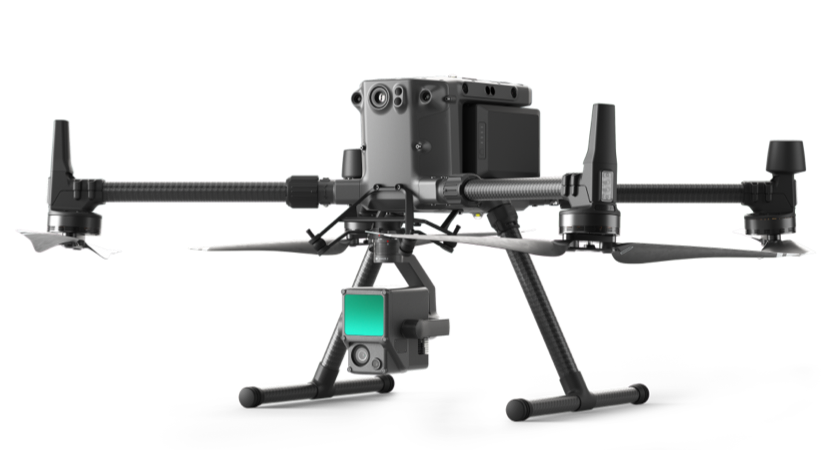 Matrice 300 RTK + Zenmuse L1
Insights derived with drone data
This valuable information has allowed Cielito Drone in collaboration with scientists from the Universidad Michoacana de San Nicolás de Hidalgo to develop a methodology to identify, geolocate and quantify oyamel trees with symptoms of stress or mortality.
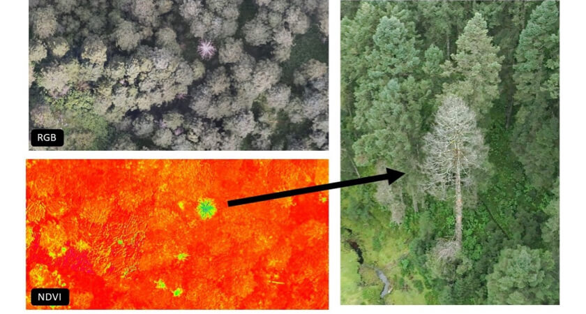 Affected trees are clearly visible with NDVI thanks to the Mavic 3M
DJI Terra
Data collected by the drones is imported and processed by DJI Terra and then a customized solution helps with tree counts and reporting tree health.
Improved safety and efficiency
By incorporating DJI technology into their monitoring and conservation workflow, it is possible to reduce accidents and risks for the park rangers who dedicate their lives to protecting this reserve.
This technology allows for multispectral and high-resolution analysis, providing information at the individual tree level. With a single flight it is possible to cover approximately 200 hectares, which translates into significant savings in time, human and economic resources. A tour that used to take 6 days can now be carried out in a single day, which is 600% faster.
Better data and insights
But the most outstanding thing is that in no way could they achieve the same level of detail (at individual tree level), both to measure the vigor/stress gradient (with multispectral images), and to count, geolocate, and quantify the biomass of each of these important trees where the butterflies hibernate year after year; increasing the efficiency of monitoring by 1200%.
Impact of results
The monarch butterfly's decline is attributed to the excessive use of pesticides and herbicides and illegal logging and deforestation of the forest areas in Mexico that serve as their winter refuge. It will require vigilance and dedication from those protecting this habitat, but equipped with drones this monumental task is increasingly feasible. Obtaining high-resolution aerial data will allow the authorities in charge of the conservation of these areas to make phytosanitary decisions for timely control and ensure that these sites continue to receive millions of butterflies every year.

-2.png?width=300&name=Insight%20blog%20featured%20image%201140X660%20(4)-2.png)
-2.png?width=300&name=Insight%20blog%20featured%20image%201140X660%20(3)-2.png)
.png?width=300&name=HS%20-%20Featured%20Images%20(7).png)