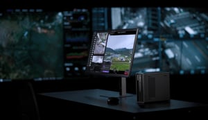

What's new in DJI FlightHub 2
This release focuses on five areas: device connectivity, intelligent planning, data analysis, automated execution, and open integration. Together, the updates move DJI FlightHub 2 further along the path from a remote-control platform toward a closed-loop system capable of automated operations.
Highlights include unified management of DJI O4 Ground Stations for signal, video, and airspace awareness; Copilot route generation from natural language; six new Analyzer capabilities spanning intelligent search, AI change detection, and defect tagging; a fully configurable automation canvas; and expanded live streaming and open API support.
Extended Coverage: Unified O4 Ground Station management
Turning fixed infrastructure into an active sensing layer
DJI FlightHub 2 now supports unified management of DJI O4 Ground Stations, using them as a combined node for communication enhancement, video ingestion, and airspace awareness.
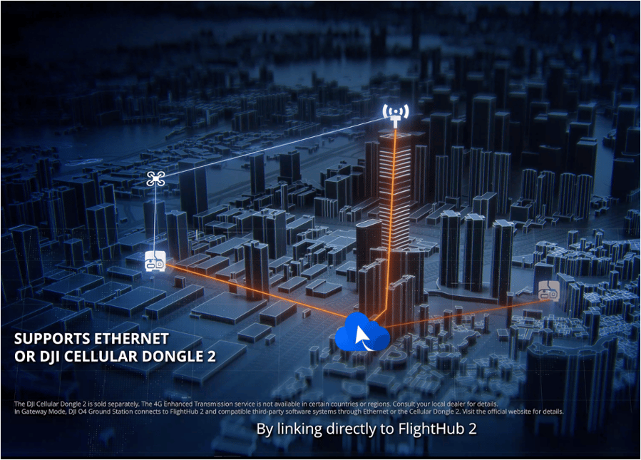
This creates a tighter link between fixed ground infrastructure and airborne assets, extending communication range and situational awareness beyond what the drone alone can cover in complex environments.
What's included:
- Signal enhancement: Cockpit and flight plan library now support selecting a nearby O4 Ground Station to establish a communication link, useful in mountainous terrain, forested areas, and other environments where structures block signal, as well as for emergency response and cross-region inspection.
- Video ingestion: DJI FlightHub 2 can now connect to network cameras using the ONVIF and GB/T 28181 protocols, letting operators view video streams and control camera gimbals directly from the platform. When a fixed camera detects an anomaly, an operator can dispatch a drone (DFR) to the location with one tap to verify it.
- Airspace awareness: The platform now supports RID and ADS-B receivers, displaying detected aircraft on the map to help operators understand low-altitude traffic in the operating area. Suspicious targets can be dispatched to for verification with one tap.
Why it matters: A drone's communication range and field of view no longer define the boundaries of an operation. Fixed ground infrastructure and airborne assets now work together, significantly extending coverage in complex environments.
Intelligent planning: Copilot generates routes from a single sentence
From technical skill to natural language
Route planning has traditionally required specialized training. The latest update changes that by extending Copilot into route generation itself.
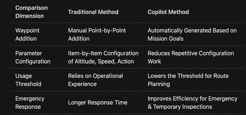
Copilot can now generate an executable flight route from four different inputs: annotated waypoints, a drawn selection area, a specified point, or a plain-language description. This supports use cases like patrolling along a path, generating inspection routes from a selected area, or stringing together map annotations into a single route.
This is especially useful for emergency response and ad hoc missions, where there isn't time for a pilot to manually plan a route from scratch.
A required safety step remains: After Copilot generates a route, an operator must still manually review eight items before execution, including takeoff and landing locations, airspace restrictions, altitude obstacles, mission parameters, flight range and battery, weather conditions, and execution monitoring. Copilot is a planning aid, not a replacement for safety review.
Why it matters: Route planning shifts from a specialized skill to a natural language interaction, particularly valuable for emergency response and temporary missions, while preserving the human safety review step that operations depend on.
Data analysis: The Analyzer becomes a full results platform
Six new capabilities, one integrated workflow
The Analyzer has been upgraded with six new core capabilities, moving it from a simple model-viewing tool to a comprehensive platform for intelligent search, change identification, defect localization, and report generation. The goal is to significantly cut the manual effort required to process large volumes of inspection data.
Intelligent search: Uses a large model to search across large volumes of media data to locate specified targets.
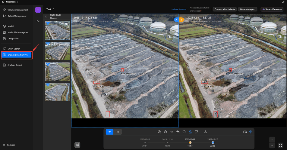
AI Change Detection Pro: Unlike traditional change detection, which relies on strict nadir (straight-down) angles and pixel-level comparison, Change Detection Pro supports comparing non-nadir photos taken from the same waypoint. Operators can select any two data collection periods and draw a selection area to focus the comparison, and the system can identify business-level changes such as facility modifications, construction progress, and material stockpiling. Missed items can be manually tagged and converted to defects with one tap, and an AI report can be generated automatically, closing the loop from detection to documentation.
Defect tagging: Addresses a common pain point: a problem is visible in a photo, but its exact spatial location isn't clear. This feature links photos directly to their position in the 3D model. Clicking any point on the model surfaces historical photos likely to have captured that location, and it can associate collection results from the same location across different time periods.
AI reports: Structured analysis reports can be generated automatically based on confirmed results.
2D/3D linkage: Provides bidirectional mapping between media data and its spatial position in the model.
Target coordinate back-calculation*: Maps a target identified in an image to geographic coordinates.
*Supports up to 10 targets per operation. Results are for reference only and do not replace professional surveying.
Why it matters: The Analyzer moves from a single-purpose model viewer to an integrated platform combining intelligent search, change detection, defect localization, and report generation, substantially reducing the manual workload of processing large-scale inspection data.
Automated execution: A fully configurable workflow canvas
From fixed templates to flexible orchestration
Automated workflows move from a fixed, preset structure to a general-purpose capability that advanced users can build and configure freely, lowering the cost of manual monitoring and improving response speed to anomalies.
Open canvas: A unified orchestration engine lets users build complete workflows by dragging and connecting nodes. Triggered and scheduled workflows are no longer separate systems; a single canvas now covers both, and five ready-to-use industry templates are provided as starting points.
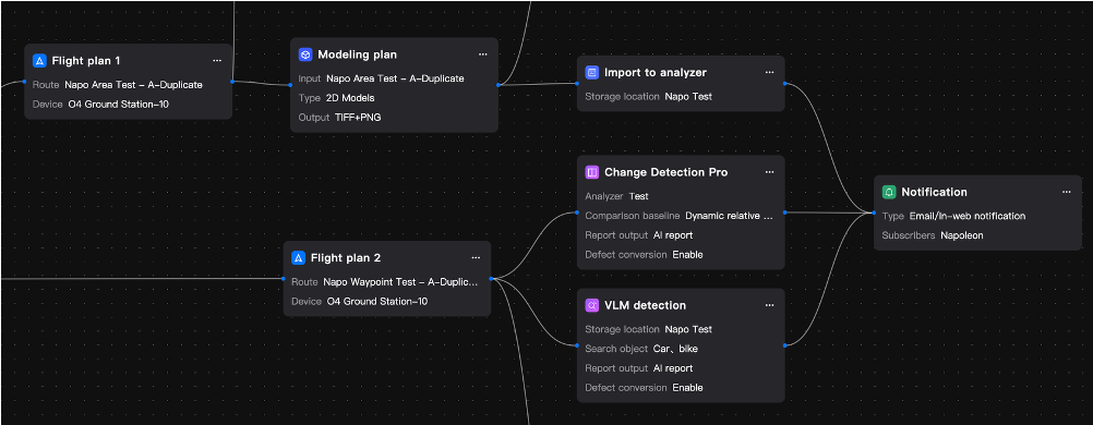
Scheduled workflow upgrade: Operators can now chain "scheduled inspection → automated data collection → AI analysis → results notification" directly into a single workflow, extending well beyond simple measurement tasks.
Triggered workflow upgrade: Adds support for DJI Dock 2, with dispatch delay configurable down to 0 seconds for immediate response after an alert. Also adds multimodal recognition, one-tap alert export, false alarm tagging, and the ability to sync execution results to third-party systems via EventAPI.
Full traceability: Every stage of the workflow- trigger, dispatch, AI analysis, notification, and result- is recorded in full, so the execution process can be tracked, reviewed, and any anomalies pinpointed precisely.
Why it matters: Automated workflows move from a fixed orchestration model to a flexible capability that advanced users can configure themselves, lowering the cost of manual monitoring and speeding up response to anomalous events.
Open integration: Live streaming and API upgrades
Closing the gap between consumer devices and enterprise platforms
This update addresses the disconnect between consumer-grade devices and enterprise platforms, and the difficulty of building on top of DJI FlightHub 2, with a set of connectivity and API improvements.
- Consumer device stream ingestion*: Consumer drones and handheld devices can now connect via the RTMP protocol, allowing unified management alongside dock-based and enterprise drone live streams.*These devices do not count against the enterprise edition's online device quota, but streaming time is billed.
- Live stream sharing 2.0: A single share link can now carry live video from multiple devices at once, suited to multi-site coordination during emergency command operations or multi-angle coverage of major events. The layout is remembered across sessions.
- Flight logs with video playback: Flight position, timestamp, and payload-captured video are now precisely aligned, improving the efficiency of mission review.
- True altitude recording and alerts*: The cockpit can now set a threshold for altitude above ground level, automatically triggering an alert when exceeded. The flight log also displays a synchronized true-altitude curve.*Calculated using DJI FlightHub 2's global elevation model and may contain inaccuracies. Not a substitute for real-time obstacle avoidance.
- OpenAPI V2.0 (public cloud): The interface system is now more complete, with public cloud and on-premises API documentation separated for clearer organization, laying the groundwork for faster iteration going forward.
Why it matters: This update further breaks down the data barrier between consumer-grade devices and enterprise-grade platforms, while giving developers a more complete set of integration tools to build on.
Summary: Three directions of progress
|
Direction |
What's included |
|---|---|
|
Broader sensing coverage |
O4 Ground Station, network camera, and airspace awareness integration |
|
Higher execution efficiency |
Copilot, triggered workflows, and improved auto-dispatch |
|
More complete analysis loop |
Intelligent search, change detection, defect tagging, and report generation |
DJI FlightHub 2 continues to evolve from a remote-operation platform into an integrated system capable of automatic discovery, automatic execution, and intelligent analysis. Looking ahead, this closed-loop automation will continue to support smart cities, energy inspection, emergency response, and other core industries as operations move toward greater automation.
Get started
The features described above are available in the latest version of DJI FlightHub 2 (public cloud).
Release notes: https://fh.dji.com/user-manual/en/release-notes/release-notes-public.html
Always comply with local drone laws and regulations when operating. Contact an authorized DJI dealer or DJI After-Sales Support if you experience any issues with your equipment or software.