
The rapid evolution of drone technology is pushing the boundaries of what is possible in various sectors, including construction, asset management, and environmental monitoring. Among the cutting-edge innovations leading this transformation is the DJI Dock 2, which enables remote and routine drone operations. However, the adoption of such advanced systems is often hindered by the lack of understanding of regulatory frameworks, especially in the European Union (EU).
EU Regulation Framework
The current EU drone regulations were introduced in an effort to standardize the rules for drone operations within all member countries. Within the EU, the European Aviation Safety Agency (EASA) has set rules for safe and responsible drone operations. According to EASA Regulations, a remote mission using a solution like the Dock 2 falls Specific Category.
Specific Category
Specific Category is designated for advanced operations such as Beyond Visual Line of Sight (BVLOS), high altitude flights (Above 120m AGL), or large drones (Over 25kg).
To operate in Specific Category, you'll need to apply for an operation permission from your National Aviation Authority (NAA). There are 3 methods to achieve it:
- STS: Standard Scenario
- PDRA: Pre-Defined Risk Assessment
- SORA: Specific Operations Risk Assessment
STS
Standard scenario is a predefined operation. An operator is not required to obtain an operational authorization to conduct an operation covered by an STS, which is a more efficient way to operate advanced operations.
EASA has published two STSs so far:
- STS 01 – VLOS over a controlled ground area in a populated environment;
- STS 02 – BVLOS with airspace observers over a controlled ground area in a sparsely populated environment.
However, they might not be the best fit for operating a DJI Dock 2 at this moment due to the lack of a Cx label conformity.
PDRA
| PDRA# | BVLOS/VLOS | Overflown area | Maximum range from remote pilot | Maximum height | Airspace |
|
PDRA-S01 |
VLOS | Controlled ground area that might be located in a populated area | VLOS |
150 m |
Controlled or uncontrolled, with low risk of encounter with manned aircraft |
|
PDRA-S02 |
BVLOS | Controlled ground area that is entirely located in a sparsely populated area |
2 km with an AO or with AOs 1 km, if no AO |
150 m | Controlled or uncontrolled, with low risk of encounter with manned aircraft |
|
PDRA-G01 |
BVLOS | Sparsely populated area | If no AO, up to 1 km | 150 m (operational volume) | Uncontrolled, with low risk of encounter with manned aircraft |
|
PDRA-G02 |
BVLOS | Sparsely populated area | (direct C2 link) | As established for the reserved or segregated airspace | Reserved or segregated for the UAS operation |
|
PDRA-G03 |
BVLOS | Sparsely populated area | n/a (direct C2 link) | 50 m from ground unless in reserved or segregated airspace | Controlled or uncontrolled airspace if height is below 50 m, otherwise reserved or segregated airspace |
AO: Airspace Observer
C2 link: Command and Control Link
The Predefined Risk Assessment (PDRA) is an operational scenario for which EASA has already carried out the risk assessment.
If users decide to operate in PDRA scenarios, they will find the operation less flexible, but the procedure is considerably simpler than SORA, facilitating a smoother process for obtaining operational authorization.
SORA
SORA is a methodology for the classification of the risk posed by a drone flight in the Specific Category of operations and for the identification of mitigation and safety objectives. If the goal is to capitalize on the technological advantages of Dock products and operate the Dock 2 fully remotely without an airspace observer, then SORA is your go-to choice.
SORA helps assess and manage drone flight risks. It's a step-by-step process involving risk assessment and safety planning. EASA provides detailed SORA information, application guidance, and example manuals.
Below are the 10 steps that need to be evaluated during the preparation of SORA.

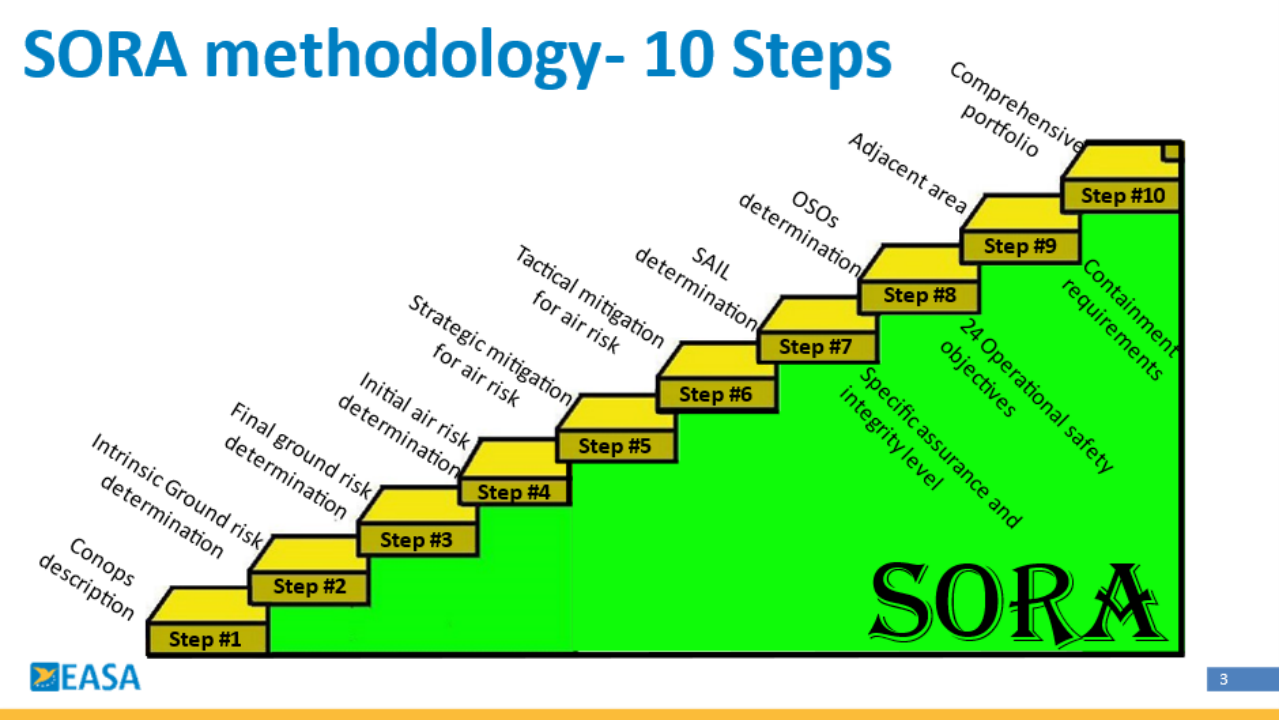
Sourced from EASA
1. The concept of operations (ConOps)
First, you will need to define the operational concept for the UAS, including the intended use, operational volume & environment, technical information, and so on.
2. Determination of intrinsic ground risk class (iGRC)
Next, assess the inherent or intrinsic ground risk of your operations. Depending on the size and weight of the drone, as well as the population density of the flight area, you will determine your intrinsic GRC (Ground risk class). If you are flying over an area without people or buildings, it is considered a low intrinsic ground risk class. If the opposite were true, you would have a high intrinsic ground risk class.
3. Determination of the final ground risk class (GRC)
This step involves integrating additional mitigations and factors to arrive at the final ground risk class. A reliable parachute or ERP (emergency responsible plan) could be an effective way to mitigate the risk. The table of specific class reductions is as follows:
| Mitigation Sequence | Mitigations for ground risk | Low/None | Medium | High |
| 1 | M1 — Strategic mitigations for ground risk | 0: None | -2 | -4 |
| -1: Low | ||||
| 2 | M2 — Effects of ground impact are reduced |
0 |
-1 | -2 |
| 3 | M3 — An emergency response plan (ERP) is in place, the UAS operator is validated and effective | 1 | 0 | -1 |
4. Determination of the initial air risk class (ARC)
Similar to intrinsic ground risk class, a UAV operator would need assess airspace risk to determine the initial air risk class of the operation.
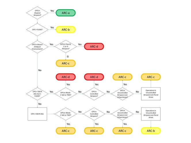
FL600=60,000 feet/18,288 meters;
TMZ: Transponder Mandatory Zone
To obtain a low-risk class (ARC-a) under the current framework operators need to fly under 100 feet, however, this limits the type of data we can collect. As a result, most commonly operators will fall under ARC-b, which allows them to fly under 500ft in uncontrolled airspace over rural areas.
5. Application of strategic mitigation to determine the residual air risk class (ARC)
This involves applying strategic mitigation techniques, similar to step 3, to reduce the air risk, leading to the determination of the air risk class.
6. Tactical mitigation performance requirements (TMPR) and levels of robustness
In this step, specific performance requirements for mitigations are identified, and levels of robustness are established to ensure safety while a drone is flying. ex. if the drone is equipped with ADS-B or other detect and avoid sensor to avoid airspace collision.
7. Final specific assurance and integrity level (SAIL) determination
This involves assigning specific assurance and integrity levels to the UAS and defining operational safety objectives based on the GRC and ARC.
| Residual ARC |
||||
| Final GRC | a | b | c | d |
| ≤2 | I | II | IV | VI |
| 3 | II | II | IV | VI |
| 4 | III | III | IV | VI |
| 5 | IV | IV | IV | VI |
| 6 | V | V | V | VI |
| 7 | VI | VI | VI | VI |
| >7 | Category C operation | |||
8. Identification of operational safety objectives (OSO)
In this step, specific safety objectives are identified to ensure safe drone operations. Operators need to present a list of documents or descriptions according to different objectives.
9. Adjacent area and airspace considerations
This step involves considering the neighboring airspace and areas to address potential impacts on drones. To address this, the operator will need to present NAA the proof document that the drone won't affect the neighboring area, such as:
- A declaration that the probability of the drone leaving the operational volume should be less than 10-4/FH.
- An independent reliable flight termination system with MoC2511 compliance.
10. Comprehensive safety portfolio
The final step involves compiling all the information, risk assessments, mitigations, and safety measures into a comprehensive safety portfolio for drone operation.
Before preparing your documentation make sure to check your local Civil Aviation Authority to understand further the specific requirements for your country.
Manufacturer Support
DJI actively supports its users through the SORA process by providing essential documentation. Including:
- Operations Manual template with Dock 2 technical information
- SORA Templates and Compliance with Requirements
- Functional Hazard Assessment Report
- Manufacturer Declarations with the probability of the drone leaving the operational volume
and so on.
If you are looking to operate the DJI Dock 2 and need support for your operation, you can fill out the survey here to check which BVLOS application method is more suitable for you and to receive the supporting documents after completing a quick survey.
If you have additional questions don't hesitate to reach out to your local DJI Authorized Dealer or contact us here.
Disclaimer:
- The documentation provided was based on SORA2.0
- Any documents or other information or resources provided by DJI are meant to be used as a reference only. DJI is not liable for any legal actions that may occur as a result of the documents provided, nor is it responsible for the outcome of your BVLOS application(s).
Success Stories
DJI has been working with partners and customers around the world to help enable the adoption of Dock solutions, some examples can be seen below:
In Germany, an authorized DJI dealer obtained BVLOS permissions for the Dock 2 for a construction site setting with a SAIL2 risk level in their SORA, achieving permission within a 3-month period.
Telink, an authorized DJI dealer in the Czech Republic, applied for BVLOS permissions for the Dock 2 for an open-pit mining scenario. Thanks to their SAIL2 risk classification in SORA, their team secured the permissions within two months. Learn more here.
There are many examples of successful approvals, demonstrating the feasibility and compliance of DJI Dock 2 operations across Europe.
The Future of Drone Regulations
As the regulatory landscape continues to evolve and technology advances, the SORA framework remains a cornerstone for safe and compliant BVLOS operations.
DJI has been at the forefront of regulatory education, consistently working to raise awareness and compliance across the industry. Our current efforts working towards obtaining the C6 Label for the DJI Dock 2, reinforce our commitment to exceeding regulatory standards.
As the demand for remote drone operations increases and the adoption of Drone-in-a-Box solutions becomes more mainstream, more safety and regulatory consulting firms will enter the drone industry. This will help make these applications more accessible for industry users.


-3.png?width=300&name=Insight%20blog%20featured%20image%201140X660%20(2)-3.png)