
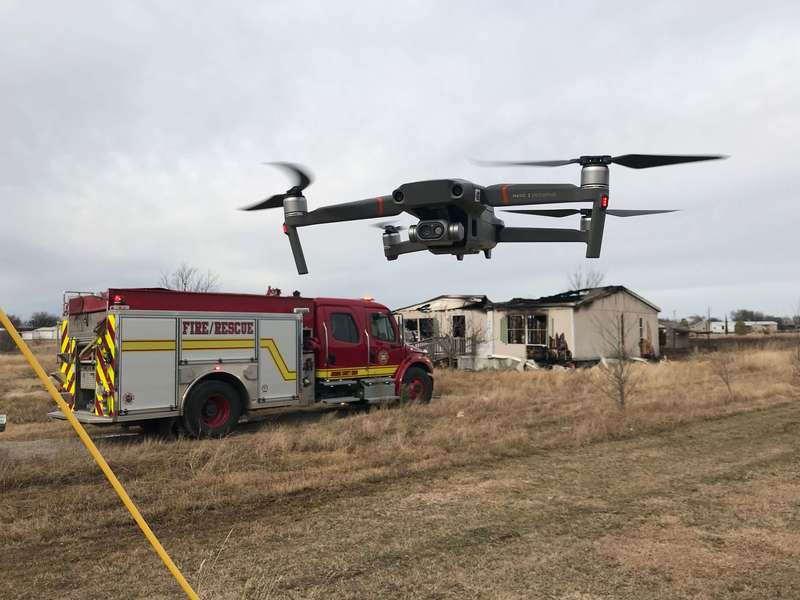
On Dec 11, 2018, the Joshua Fire Department, in joint effort with the Godley Fire Department, responded to a structure fire in an abandoned house located between the cities of Joshua and Godley. When they arrived, they noticed the flames had spread into the nearby grass and was quickly advancing north towards several residential homes.
Every minute of delay meant more damaged property and potentially the loss of life. Fire Chief Wayne Baker moved quickly to the scene. He assembled his firefighters and the Joshua drone operations team, assisting the incident commander to lead the charge against a 2000-ft2 blaze. Fortunately, it had yet to reach the surrounding residential homes.

Containing the Spread
Containing and extinguishing the spread was mission number one. The drone operations team wasted no time setting up their newly added Mavic 2 Enterprise Dual (M2E Dual), launching it within 1-3 minutes. The M2E Dual’s compact design and intuitiveness to fly proved why it was the perfect tool for a swift initial size-up of the area.
Equipped with dual sensors, the drone provided both visual and thermal imaging, helping the incident commander to obtain key intel. Locating and containing hotspots was of vital importance. The drones operations team needed to extinguish any flare-ups and were able to identify them quickly by enabling the M2E Dual’s Isotherm feature. Essentially, they utilized customized color palettes to achieve higher contrast and better visibility of the area. This allowed them to identify and prioritize fire spots while ultimately increasing the speed at which they were extinguished.
“We were able to put out the grass fire in 30 minutes. The M2E Dual’s thermal aerial imagery gave us good vision of what’s on fire and how to access the burning areas quickly,” commented Chief Baker.
Garret Bryl, volunteer pilot for the Joshua Fire Department and consultant for the North Texas Unmanned Aerial Systems (UAS) Response Team, led all drone operations during the incident. “For a compact thermal drone, it performed beyond our expectation, with details good enough from several hundred feet away,” Garret Bryl commented.
About the size of a water bottle when folded, the Mavic 2 Enterprise Dual is easily deployable and compact enough for first responders to carry around in their pockets.
Tackling the House Fire
After finally dousing the grass fire, the team refocused on the abandoned house. Again, their first priority was detecting hotspots as swiftly as possible.
The Mavic 2 Enterprise Dual’s FLIR MSXTM technology overlaps the standard visual image with a thermal one. Firefighters were able to pinpoint hot areas quickly while improving their awareness of various objects within the house. This not only reduced their time on scene by at least 75%, but it also kept firefighters out of harm’s way, according to Chief Baker.

The FLIR MSXTM on the Mavic 2 Enterprise Dual overlaps the visual and thermal imagery, allowing firefighters to compare the strength of a flame in various areas of the house.
“The M2E Dual’s strong sensors and incredibly smart features provides a high level of situational awareness to our pilots. My drone team members have all become experienced with thermal imagery from our use of drones over the years. However, even for the firefighters that are not familiar with drones, one look at the screen and they could immediately identify various hotspots in the house, as well as the safest way to access them,” Chief Wayne Baker commented.
Both fires were put out two hours after the teams’ arrival. The M2E Dual’s Temp Alarm feature helped the team conduct another scan of the entire area by automatically notifying them of additional hotspots and enabling them to take quick action to prevent any extinguished fire from rekindling.
The M2E Dual’s compact size, ease of use, and its ability to provide detailed thermal imagery is what makes it an incredibly valuable and cost-effective tool to have during small-scale emergencies.
“You can’t expect it to generate the same level resolution and details as a higher-end solution, like the M210 with XT2. For larger area operations like a rescue or a factory fire, you’d switch to the bigger drones. However, the M2E Dual works great for smaller-scale emergencies like this house fire incident. For most mid to small-sized departments, this is what we deal with every day. And budget-wise, the cost effectiveness of the M2E Dual is what impressed us the most,” Garret Bryl stated.
Garret Bryl, Chief Wayne Baker, and the rest of the Joshua Fire Department operations team have demonstrated how drone technology can be incredibly beneficial during emergencies. Drone programs have undoubtedly enhanced their overall capabilities in the field and they have in return agreed to share their expertise with other public safety departments.
Drone Tech Pushed to New Heights
The Joshua Fire Department is one of the first public safety institutions to establish a drone program. In 2014, the department assembled its drone operations team, after introducing everyone to the DJI Phantom 2, their first drone to be used in the field.
After months of initial training and years of practice in actual operations, they eventually became one of the most experienced emergency response drone teams across the United States.
As one of the earliest adopters of drone technology, the Joshua Fire Department made significant efforts to share their knowledge and expertise with other communities. They are one of the founders of the Public Safety UAS Response Team (PSURT), a state-recognized program with 47 public safety departments from fire and police departments to emergency management agencies. Chief Baker and his team have taken an active role in assisting with the training of pilots and sharing their experiences in drone operations. The PSURT will operate regionally across Texas, allowing teams to collaborate on program expansion, provide each other with drone operation support, and help solve staffing challenges in the event of an emergency.
For departments that are looking to start their drone programs, Chief Baker has the following advice:
- First, define 3-4 key missions your department wants to use drones on. Having a clear idea of what situations you anticipate a drone being beneficial in will help you determine which sort of training and equipment will serve your program best.
- Understand the FAA and any federal, state, and local policies that may influence your drone program. Proper training is key.
- Your team not only needs to know how to fly a drone and take pictures with it. You also need to practice collaborative operation in emergency situations, as well as effective analysis of drone intel during a mission.
- It is essential that on-the-job training is continuous. An expert pilot comes from diligent field practice and the development of the skills necessary to perform under pressure during emergencies.
DJI has continuously collaborated with the Joshua Fire Department and various other enterprise teams in drone technology integration, R&D, establishing educational programs and offering hands-on training. The European Emergency Number Association (EENA) has worked closely with DJI, publishing two reports on the efficacy of drone technology during search and rescue missions. To learn more read our DJI Enterprise White Paper.
Drones are changing how government agencies serve the public in big ways and small. While drones have gained an early foothold in public safety, enterprising government agencies and departments are exploring their use in other areas, from transportation and public works to planning and environmental services. For more information about setting up a drone program and learning about best practices to consider as you evaluate how drones could help meet the needs of your community, download this comprehensive report.
-2.png?width=300&name=Insight%20blog%20featured%20image%201140X660%20(3)-2.png)
.png?width=300&name=HS%20-%20Featured%20Images%20(7).png)
-1.png?width=300&name=HS%20-%20Featured%20Images%20(5)-1.png)