
In the world of geospatial data and 3D modeling, precision is everything. Whether captured by aerial LiDAR or ground-based scanning, point cloud data serves as the foundation for countless applications—from construction and infrastructure to forestry and powerline inspection.
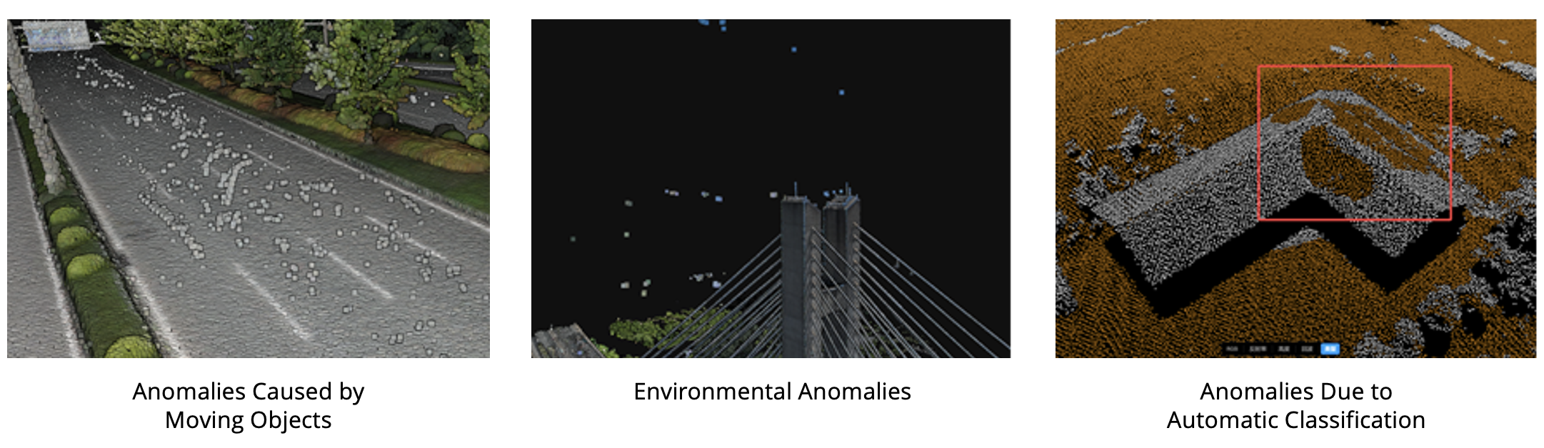
However, due to the limitations of LiDAR sensor performance and environmental interference, automatically reconstructed point clouds may contain noise or misclassified elements. These issues often require manual post-processing for optimization.
DJI Modify V1.4 Officially Released
Recognizing these pain points, DJI introduces Modify V1.4, a powerful update that transforms how professionals approach point cloud editing. It delivers a comprehensive intelligent point cloud editing workflow. It introduces advanced preprocessing tools, intelligent editing capabilities, enhanced output formats, and 3D Profile tools. These features help users quickly and efficiently generate high-quality, analyzable point cloud data.

Overview of DJI Modify’s Point Cloud Editing Features
Point Cloud Preprocessing
1. LAS File Import
DJI Modify supports smooth editing of ultra-large-scale point cloud data, with a maximum of 4.2 billion points per LAS file. It can load point cloud files up to half of the available system memory. For example, with 30GB of available RAM, you can load approximately 15GB of point cloud data.
The software is compatible with various sources of LAS data, including those from aerial LiDAR surveys and ground-based scanning.
2. Smoothing, Noise Reduction, and Density Adjustment
After creating a new project and selecting a LAS point cloud data file, DJI Modify can perform smoothing, noise reduction, and point cloud density adjustments on the LAS data, enhancing the overall quality of the point cloud through automated algorithms.

Point Cloud Preprocessing
3. Automatic Point Cloud Classification
DJI Modify uses intelligent classification algorithms to automatically assign points to categories including:- Ground
- Vegetation
- Buildings
- Wires
- Electric Towers
- Dynamic objects
- Vehicles
 Automatic Point Cloud Classification (GIF)
The software also supports reclassification or terrain classification after importing point clouds.
- Smart Classification: Ideal for urban or multi-building scenes, supports earthwork or terrain surveying.
- Terrain Classification: Separates ground from non-ground points.
 Reclassification
Intelligent Point Cloud Editing
1. Multiple Viewing Options
DJI Modify employs a proprietary point cloud rendering system for a smooth 3D editing experience. The EDL (Eye-Dome Lighting) display mode enhances the visibility of point structures. It supports multiple viewing options:
- RGB
- Classification
- Elevation
- Reflectivity
- Number of Returns
- RGB Overlaid on Classification
The model view can also display both the coordinate system and point coordinates under the cursor.
Multiple Viewing Options (Video)
Users can also hide or display point cloud layers and specific classifications. Each class supports custom ID, color, renaming, deletion, and export.

Hide/Display
2. Rectangle/Polygon/Point SelectionSupports polygon, rectangle, and point selection tools. The polygon and rectangle tools use perspective selection, capturing all points in front of the selection window. Selected points can be locally edited or deleted.

Rectangle/Polygon Selection
3. Color & Brush Selection- Color Selection: Allows selection of points with similar RGB values based on a tolerance setting—ideal for targeting color-consistent features.
Color Selection (Video)
- Brush Selection: Freeform selection using a configurable brush radius, perfect for irregular surfaces and manual refinements.
Brush Selection (Video)
4. Quick Selection
For point clouds that have already been automatically classified, users can quickly select specific classes (e.g., power lines, poles, trees) with a single click. This is especially useful for correcting misclassified data efficiently.
Quick Selection (Video)
5. Structure SelectionLeverages intelligent algorithms to identify and select planar structures (ground, rooftops, walls) and linear features(power poles, wires) to support localized intelligent editing.
Structure Selection - Rooftops (Video)
6. Selected Point Cloud ProcessingUsers can select a specific region to apply noise reduction, smoothing, or downsampling to optimize data quality while reducing file size.
Noise Reduction (Video)
Additional Functions
1. Profile Tool
This essential analysis tool enables slicing through point cloud models for tasks like:
- Penetration assessment
- Precision analysis
- Power line inspection
- Terrain and forestry evaluation
Profile Tool (Video)
2. Vector Output
From the refined point cloud, DJI Modify can generate:
- Digital Elevation Models (DEMs)
- Contour
- TIN (Triangulated Irregular Network)
- Gridded Point
These outputs can be directly imported into CAD or GIS software for advanced analysis or industry workflows.

Latest Updates Across DJI Software Ecosystem
DJI continues to advance its 3D reconstruction solutions, delivering powerful tools for professional mapping, surveying, and modeling:
-
DJI Terra V4.5 now supports:
-
Local PPK (Post-Processed Kinematics) for a wider range of enterprise drones
-
Custom Ground Sampling Distance (GSD) settings for 2D maps
-
Task scale constraints using visible light imagery
-
-
DJI Modify V1.4 introduces a fully integrated point cloud editing workflow, offering intelligent preprocessing, classification, and editing tools for efficient data refinement.
-
DJI Terra API V1.3 adds functionality for:
-
Ground point classification
-
Custom GSD configuration in 2D mapping tasks
-
For more information on these updates and to explore the full capabilities of DJI’s software suite, please visit the Software Homepage.

-2.png?width=300&name=HS%20-%20Featured%20Images%20(2)-2.png)

