
In 2013, DJI developed the Geospatial Environment Online (GEO) safety solution to help prevent drone operators from inadvertently flying into high-risk locations without authorization. This sophisticated geofencing system, along with several other voluntary safety features that DJI integrates into its products, continues to have an outsized impact on the safety record of drones.
Admittedly, the GEO system is broadly designed to keep newcomer and recreational drone users away from airports, important government institutions, prisons, nuclear power plants, and other sensitive areas. But DJI drones are used by recreational, commercial, educational, humanitarian, and governmental users alike. And so, the system allows flexible unlocking based on operator judgment.
At the same time, DJI understands that government and public safety operators need to deploy their drones at any time, at any height, and at any place – no matter whether there is a no-flight zone or not. This is where the Qualified Entities Program comes in.
What is DJI Qualified Entities Program (QEP)?
The Qualified Entities Program (QEP) provides DJI drone operators with long-term unlocking certificates, so they can fly in sensitive locations, and at higher altitudes, for critical operations such as firefighting, search and rescue (SAR), and disaster response.
Developed specifically to minimize operational geofencing restrictions for pre-verified governmental and public safety users, QEP allows participating agencies to get their DJI drone’s altitude and geofencing limitations unlocked for an extended period – a minimum of five calendar years to be precise – negating the need for creating a separate unlock request before each mission.
Where Is QEP available? Who can apply?
QEP is currently available in the United States, Canada, and Europe. If you’re located elsewhere, you can still able to obtain a long-term unlocking certificate for your DJI drone by submitting an application as a government entity through the Fly Safe portal. This step-by-step guide explains how you can operate in a no-fly zone (NFZ).

Government and public safety entities, such as fire services, SAR, coast guard, civil defense, law enforcement, border control, etc., can apply for the program.
After submitting the necessary documentation, you’d be able to download an unlocking certificate onto the drone linked to your DJI account. Once this certificate is enabled, your drone would takeoff seamlessly, regardless of geofencing restrictions within the country of application.
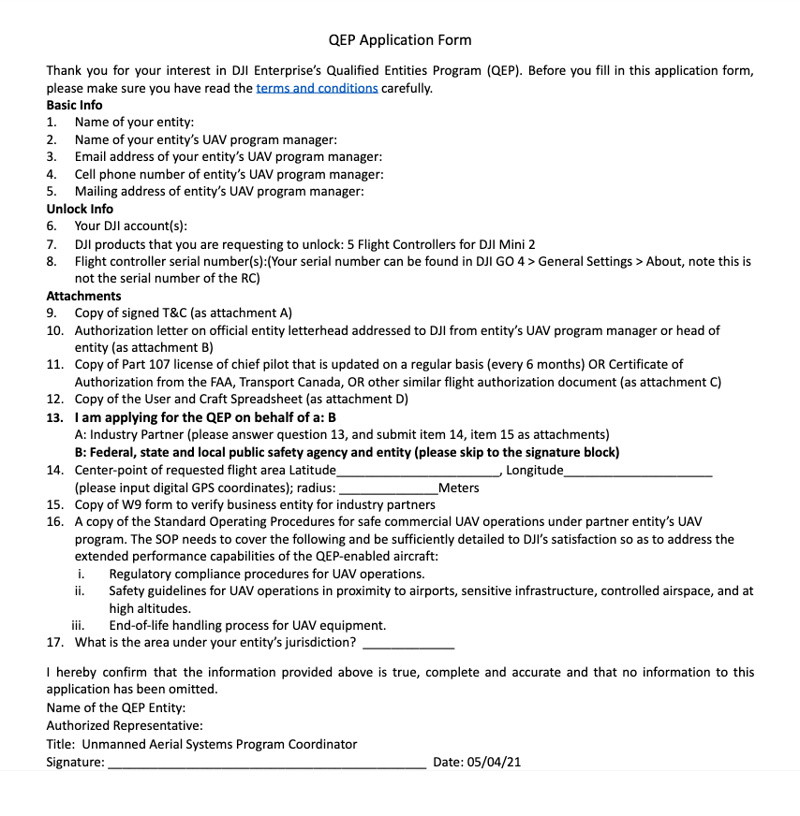
Submitting your QEP application
-
If you’re in North America (US and Canada)
Download the QEP application form for North America here. Fill it in. Review and sign the Terms and Conditions. And provide a letter on your department's letterhead, requesting for all the listed aircraft to be unlocked through QEP.
You would also need to provide a copy of the certification obtained by the chief pilot (FAA Part 107, Certificate of Authorization, or Transport Canada Pilot Certificate, etc.) along with any related documents to show currency.
-
If you’re in Europe
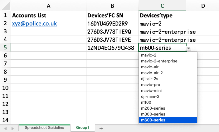
Download the QEP application form for Europe here. Fill it in. Review and sign the Terms and Conditions. And provide a DJI Account created with an institutional email address such as xyz@police.co.uk.
All documents need to be signed and stamped by the head of the entity.
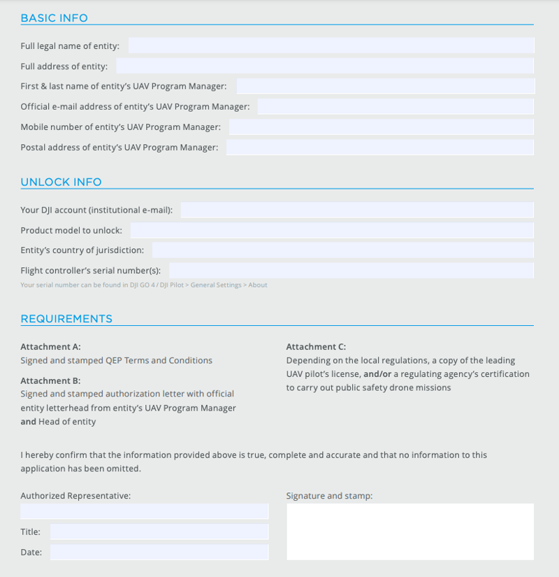
Fill out the “User and Aircrafts QEP” Excel spreadsheet
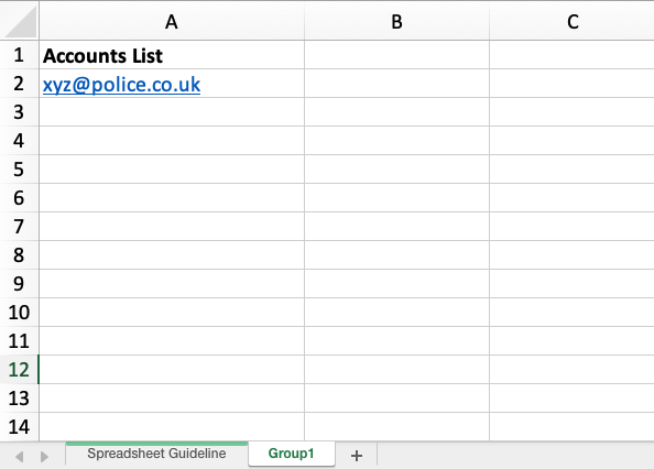
Fill out the “User and Crafts” Excel spreadsheet by providing flight controller serial number information, DJI user account(s), and aircraft type(s). If you have a large fleet size, you can click on “Group 1” on the bottom tab to add information.
- The “Accounts List” column needs to be filled with the email address used to log in to your DJI account, either on the website or in the app. Don’t have a DJI account? You can create one here: https://account.dji.com/register.
Pro tip: Using one DJI account instead of multiple can make workflow easier for QEP purposes.
If multiple DJI accounts are used with the same drone, each time a different DJI account logs in on the DJI app, the unlocking certificate for that account will need to be downloaded and enabled. But if the same DJI account is used, the unlocking certificate will need to be downloaded and enabled only once. - Next, you want to list the flight controller serial numbers under the “FCSN” column. You’d find a document detailing this process in the application package, but generally, it would look something like this:
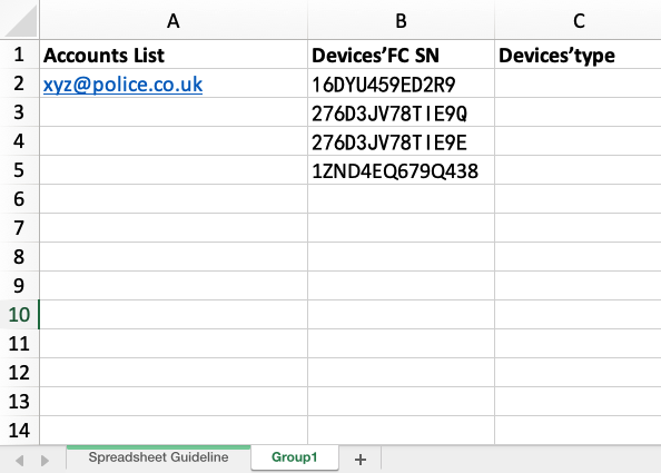
Do remember that the letter “O” and the number “0” can be confused. If in doubt, you can share a picture with qep.na@dji.com or qep.europe@dji.com, for North America and Europe respectively.
Pro tip: Make sure that you're providing the drone's S/N here, not the Remote Controller S/N. - The last column on your spreadsheet lists out the “Device Type”. Click on a cell to see a drop-down menu option and choose the closest model. For example, if you do not see Mavic 2 Pro, choose Mavic 2. Essentially all DJI aircraft can be unlocked through QEP, barring a couple of extremely old models such as the Phantom 1 and Phantom 2.
- US and Canada: qep.na@dji.com
- Europe: qep.europe@dji.com
If the information on your forms checks out, your application should be approved within 24 -74 hours in the US or Canada, and within 10 working days for Europe.
If you haven’t heard back after submitting your QEP application and it has been more than the above specified time period, please send a follow-up email. If you have not received a confirmation email back from the QEP team the reply email sent to you may have been blocked as spam by your email server. Please try again using a different generic email account such as Gmail.
Downloading and enabling your QEP certificate
Once your QEP application is approved, you will receive an email containing your QEP certficiate. The next step is to download the certificate to your drone(s) using the DJI Pilot App.
The steps to do this are the same as when downloading and enabling a Custom Unlock Certificate, which we have outlined in detail here.
Modifying aircraft or accounts approved under QEP
To add or remove aircraft or users at any time, you may send an updated spreadsheet to the QEP team.
For example, if a drone is repaired or replaced, the FCSN will most likely have changed. Thus, an updated spreadsheet or the new drone information will need to be sent to DJI’s QEP team. Similarly, if a drone was lost or stolen, you’d need to report its FCSN to the QEP team to remove it from your application.
For North American QEP customers, DJI will send you an email twice a year, requesting a review of your documents. This will be your opportunity to update documents (renewed Part 107s, updated COAs, etc.), add or remove aircraft/user accounts, and update any contact information.
Not only does this review process allow DJI to ensure that all information is up to date but it also serves as a reminder to the drone program lead to review the fleet and make necessary updates.
Altitude unlock for mountainous terrain
By default, the maximum altitude for QEP unlocks is set at 500m. However, this can be increased by sending the QEP team a request over email.
QEP altitudes can be increased for the following drones:
Phantom 4 Pro V2/V2+, Phantom 4 RTK, Phantom 4 Multispectral, Mavic Air/Air 2/Air2S, Mavic 2/Mavic 2 Enterprise Series, Inspire 2, Matrice 200 V2 Series, Matrice 300 RTK, T10/T16/T20, DJI FPV, Mavic Mini, and Mini 2.
How DJI’s QEP initiative is making a difference
The Southern Manatee Fire & Rescue (SMFR) HazMat Team in Florida, US, is a QEP member. Being a part of this program allows SMFR to span larger areas from a higher perspective in the sky, thereby improving response times to major incidents.
“Previous to drones there was no way to keep eyes on our guys,” says Rich Gatanis, UAS Coordinator, SMFR. “We relied solely on radio traffic, which is shoddy at best. Having an eye in the sky enhances our ability to mitigate a scene. It helps us understand what they see a lot faster and ensures everyone works from the same operational picture. Nothing compares to everybody looking at the same video in real-time. It allows us to significantly cut down on misinformation.”
And then there is the Swedish Police Authority, which is running one of the biggest public safety drone programs in Europe. The agency has equipped each police vehicle in its UAS program with a drone and helped more than 200 officers across Sweden to earn the licenses and certifications required to operate drones during law enforcement activities. This has increased the safety and security of the citizens dramatically.
As Rickard Henningsson, Process Manager Airborne Policing-UAS, explains:
“These specialized units are trained to cover everything from densely populated regions to large areas requiring wider coverage. Since we have joined DJI’s Qualified Entities Program (QEP), our drones do not have any limitations in terms of altitude or geofencing. Our officers can conduct their drone operations without restrictions.”
Final Thoughts
Ease of use has always been a hallmark of DJI drones and the QEP initiative is yet another way for DJI to support the public safety sector by understanding the importance of the time-sensitive missions first responders carry out.
If you’re a government or public safety organization, you can also apply for the DJI QEP program and have your altitude and geofencing limitations unlocked over an extended period of time.


-3.png?width=300&name=Insight%20blog%20featured%20image%201140X660%20(2)-3.png)