Ever since it was announced in 2019, DJI Terra drone mapping software has been helping professionals to achieve incredible feats. From capturing every little detail on centuries-old historical monuments to mapping rivers flowing through busy cities, DJI Terra is empowering professionals to transform drone data into powerful digital assets in record schedules.
At the same time, the mapping and modeling solution is improving rapidly. In this latest release, a plethora of new features are being introduced, including the addition of seven-parameter transformation in Output Coordinate System Settings and automatic refinement of water surfaces in 3D Reconstructions.
Seven-Parameter Transformation for 2D, 3D Reconstructions
If you are mapping multiple regions in a small area, say within 50km2, or there’s a single construction area that needs to be mapped regularly, you can use the new seven-parameter transformation feature in DJI Terra to make your 2D or 3D reconstruction models more accessible.
With seven-parameter transformation, a known coordinate system can be converted to a local coordinate system without placing or marking ground control points (GCPs). In simple words, you can convert WGS84 locations used by GPS to local datum coordinates. In addition, LiDAR data can also be transformed into the local coordinate system through seven-parameter transformation.
The feature can prove handy in some large-scale survey scenarios too. For example, while mapping a large area, you would want the output in a projected coordinate system (PCS). The seven-parameter transformation process can reduce the error between coordinate conversions when the projection of the target coordinate system is unknown.
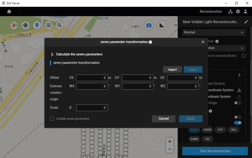
To use this feature, go to Reconstruction Mission –> Advanced –> Output Coordinate System –> Seven-Parameter Transformation. On the displayed dialogue box, add coordinate information directly or import files.
Adding coordinate information directly
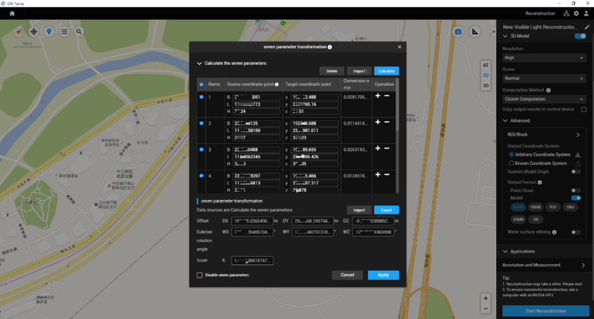
Input coordinate data, click “Calculate”, and then tap “Apply”.
Importing files
1. Import coordinate files (in TXT or CSV format), click “Calculate”, and then tap “Apply”.Coordinate data in the file should be in this order: name of the coordinate pair, latitude, longitude, and height of the source coordinates, X/E, Y/N, and Z/U of the target coordinates. Note that source coordinates only support the geodetic coordinate system. Separate the data with commas (TXT file) or fill data in different columns (CSV file) as shown below.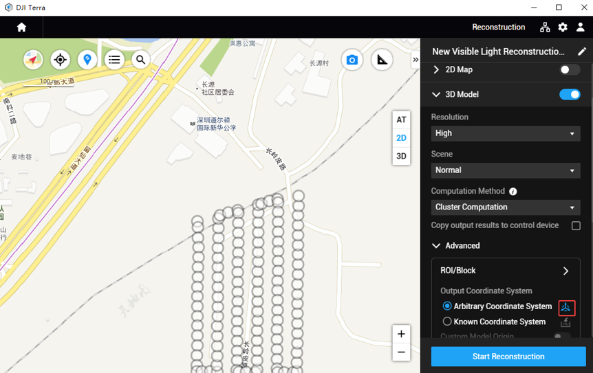
2. Import the result file (JSON format) of the Seven-Parameter Transformation and then tap “Apply”.
Click “Start Reconstruction” and wait for the reconstruction to complete.
Known Coordinate System Database in DJI Terra
With this update, we have also added support to select vertical and horizontal coordinate systems for the United States, Germany, Denmark, and Japan when generating 2D and 3D reconstructions.
To use this feature, go to Reconstruction Mission –> Advanced –> Output Coordinate System –> Known Coordinate System.
Select “Horizontal coordinate system database” and “Vertical coordinate system database” from the “Horizontal Datum Settings” and “Geoid Settings” in the drop-down menu. Input the coordinate system name or authorization code, and select the desired coordinate system in the searching results. Then, tap “OK”.
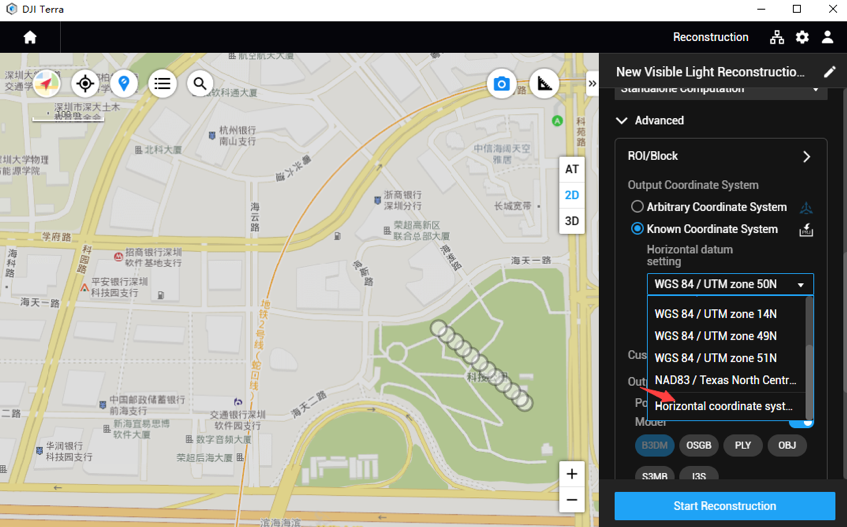
If the selected vertical coordinate system requires importing the corresponding geoid file, you can search and download it here. Once you import the downloaded file to DJI Terra, you can start the reconstruction process.
Please note that in the current version, you need to check the description of the geoid file to know which one to choose.
Refining Water Bodies in 3D Reconstruction
When your reconstruction area covers a large area of water surfaces, enable the “Refine Water Surface” feature in “Advanced Settings” and DJI Terra will automatically identify and refine water bodies for you.
Combining Multiple Point Clouds
If you’ve conducted multiple scans of an area or an object, but now need to accumulate all the data into one comprehensive point cloud, try the new “Merged Outputs” feature in DJI Terra. This functionality supports output in PLY, LAS, or PCD formats.
LiDAR Point Cloud Process Quality Report Improvements
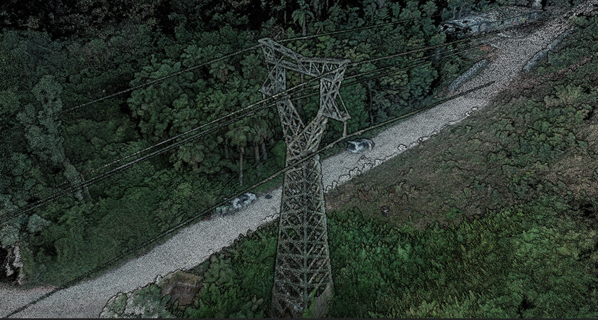
DJI Terra creates quality reports of all missions to ensure that the results meet your accuracy standards. With v3.5.0, we are adding warnings to the quality report of LiDAR point cloud missions to explain possible reasons for low accuracy or missing point clouds, if any.
Enhanced Block Splitting Options
While you could already select the block splitting mode for efficient data management and updates during 3D reconstructions, now you can see the exact block count and assign different names to Auto and Custom blocks as well.
Troubleshooting Optimizations
DJI Terra now offers troubleshooting instructions alongside reconstruction error prompts, so your issues can be resolved at the earliest.
However, if there is a software error or if Terra crashes during a mission, you will now be able to access the corresponding log file using the keyboard shortcut “Ctrl+Alt+L” inside Terra or through the storage path below:
C:\Users\<computer name>\AppData\Roaming\DJI Terra\log
You can export this log and send it to DJI Support for analysis.
Bug Fixes
The update includes the following bug fixes:
- Fixes an issue where content preview could not be updated by dragging after importing POS files.
- Fixes an issue that caused the flight route waypoint check to fail when KML or point cloud was changed in detailed inspection missions.
- Some S3MB format files could not be viewed properly in SuperMap.
- In 2D reconstruction data with a vertical camera angle of less than 35°, memory consumption was high.
- When the aerotriangulation results were dragged downward in a Region of Interest (ROI) with the angle of positive view, the results appeared enlarged.
- Some multispectral tasks would see a partial loss of results after breakpoint construction.
For complete documentation of the changes that come with v3.5.0, you can refer to DJI Terra Release Notes.
Get Started with DJI Terra
DJI Terra comes in four versions: Agriculture, Pro, Electricity, and Cluster. To purchase the mapping software that has been developed by the team that makes DJI drones, and hence is able to extract the most accurate results from them, visit the DJI Online Store or contact an authorized dealer.
Also, we continuously engage with our users to optimize and improve our products, which makes updates like this a regular feature. Make sure to subscribe below, so you don’t miss out on any future updates for DJI Terra.


.png?width=300&name=L3kv%20(1).png)

.png?width=300&name=FH2%20update%20(1).png)
-1.png?width=300&name=HS%20-%20Featured%20Images%20(3)-1.png)