
Our passion for innovation and excellence has led us to create revolutionary products that empower users across industries, and the Matrice 300 RTK is a prime example of that.
Ever since its release in May 2020, the M300 RTK has offered unparalleled performance and stability, even in the most challenging conditions and circumstances. Be it the Three Propeller Emergency Landing mode or a slew of category-defining features that it packs in, the M300 RTK has continued to excel in areas like surveying, inspection, mapping, and emergency response.
And now, in our continued effort to equip you with the best, most robust industrial drone platform, we have released our first firmware update for 2021. The update, v02.02.01.02, will empower your M300 RTK drone with new functionalities, enhance its safety features, and address some known issues.
Here’s everything you need to know about this new update…
New Features
1. DJI P1 Support
Our most powerful drone yet is now ready to support our most powerful camera payload dedicated to geospatial data acquisition, the DJI Zenmuse P1. The P1 integrates a 45-megapixel full-frame low-noise high-sensitivity sensor on a 3-axis stabilized gimbal, and supports a variety of fixed-focus lenses.
The P1 is now available for order through official DJI dealers and we are excited to see how photogrammetry professionals leverage its unique features to work faster and smarter.
2. CSM Radar Support
The Circular Scanning Millimeter-Wave (CSM) Radar is a mountable accessory that increases the situational awareness of M300 RTK platform’s six visual collision detection sensors. This IP45-rated product can accurately identify thin objects such as powerlines and tree branches even during a night flight, so you can fly safely even in close proximity to your target.
Updating your M300 RTK drone to the latest firmware version will allow you to use both the vision sensors and the radar system – together and individually alike.
Improvements
1. Updated Elevation Parameters
Elevation models are important for many geospatial applications. Previously, the M300 RTK showed elevation based on the ellipsoidal height of the aircraft, which is measured by the GNSS/RTK system. This system uses a theoretical sea level estimated by a World Geodetic System (WGS84) ellipsoid, which does not perfectly follow the theoretical global mean sea level.
In the real world, the orthometric height (altitude above mean sea level using a geoid model) is more intuitive and supported by many geographic information system (GIS) platforms. This is why the latest firmware of M300 RTK clearly differentiates between different elevation models and offers three distinct parameters in the DJI Pilot app:
ASL: Altitude above (mean) Sea Level (using EGM96 geoid model)
ALT: Height from takeoff point
Ellipsoidal Height: The ellipsoidal height of the aircraft measured by GNSS/RTK system (using WGS84 by default)
Here’s how you will see these elevation parameters play out in the Primary Flight Display…
-
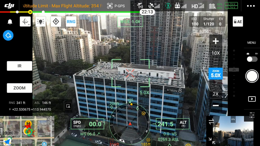
In the FPV/Camera View
Both the ASL and the ALT of the aircraft are displayed in the FPV/camera view. If you enable the RNG function (laser rangefinder), the ASL of the target point will also be displayed.
-
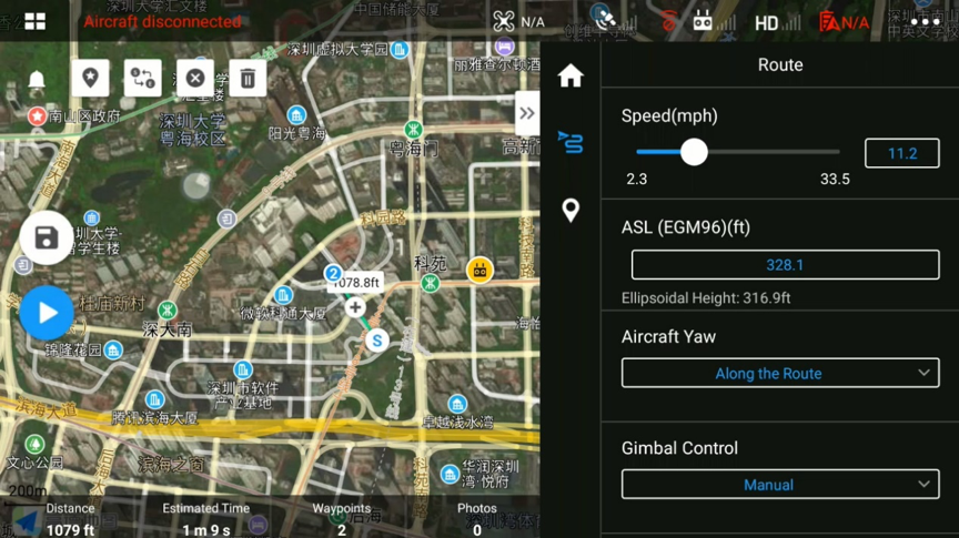
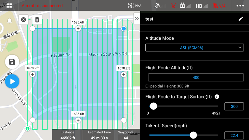
Waypoint Mission Planning
In a waypoint flight mission, if you select ‘M300 RTK’ as the aircraft model, you can choose to plan the mission with either ALT or with ASL (EGM96). If you pick ALT, all of the waypoints’ elevation would be relative to the height of the takeoff point. So, if the takeoff point was changed to be 10m higher than the original one, the entire mission will then be 10m higher than the planned one. But if you plan the mission based on ASL (EGM96), the route will not change no matter where your takeoff point is.
In the ASL (EGM96) mode, you can input the ASL of a waypoint or the entire route. The ellipsoidal height value for this point/route will also be shown in the Pilot App under the ASL altitude input field. In order to be compatible with the previous firmware versions, the ellipsoidal height value is recorded in the KML file of the waypoint flight mission.
-
Survey Mission Planning (Mapping/Oblique/Linear Flight Mission)
In a survey mission also, you can also choose the Altitude Mode to be either relative to takeoff point (ALT) or ASL (EGM96). When ALT is selected, you must set the Flight Route Altitude and the distance from the takeoff point to the target surface. This is necessary to ensure the GSD and overlap ratio calculations are correct when the terrain to map and the takeoff point differ in elevation.
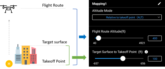
Meanwhile, in the ASL (EGM96) mode, you can plan the mission by setting the ASL of the flight route and the distance from the flight route to the target surface. And the flight route will not change even if the elevation of the takeoff point changes.
-
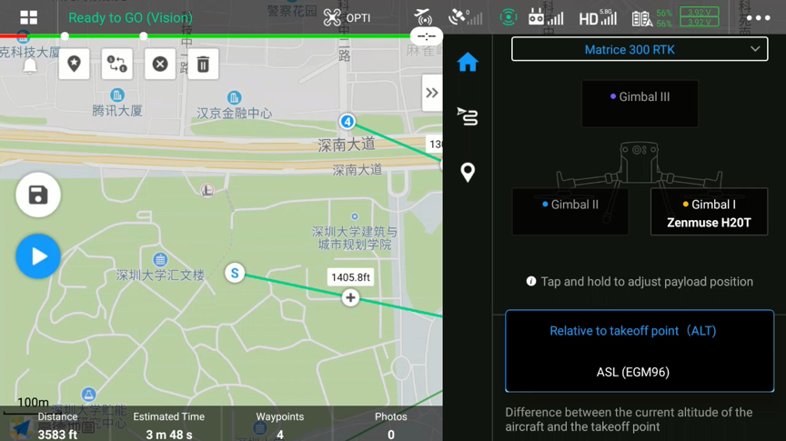
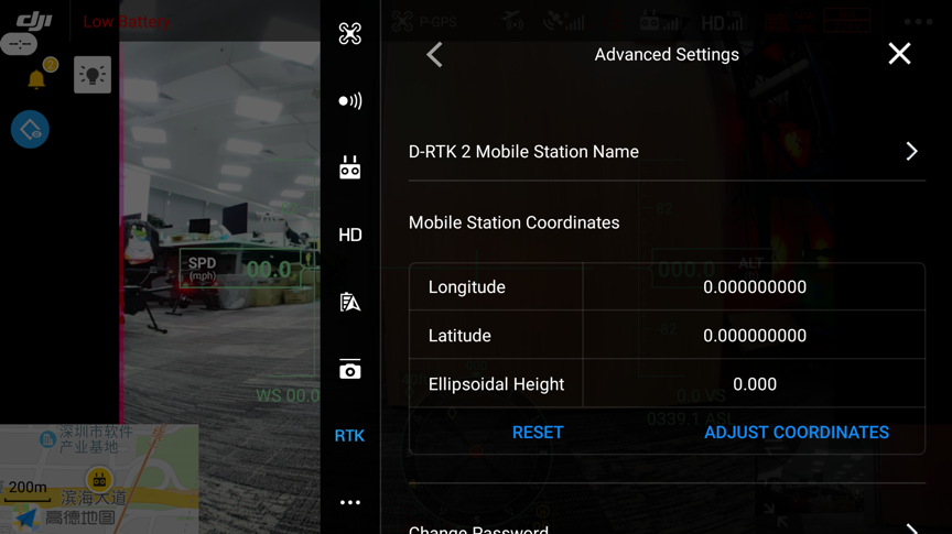
RTK Settings
In the RTK Settings page in DJI Pilot App, the ellipsoidal height of the aircraft and the RTK station are displayed. In the Advanced Settings of the D-RTK 2 mobile station, the measured coordinate and ellipsoidal height of the D-RTK 2 station can be input.
-
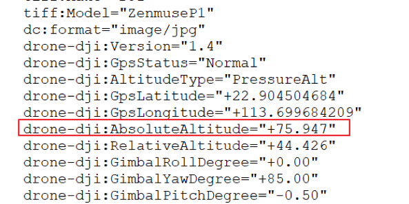
Photo Metadata
Height information is included in the EXIF/XMP data of a photo taken by M300 RTK with H20 Series or other payloads. For example, if you open the JPG file with a text editor, you can find the ‘AbsoluteAltitude’ value referring to the ellipsoidal height of the aircraft when the photo was taken.
Note that the positioning and altitude data in photos will continue to be used for 2D and 3D modeling in DJI Terra.
A Terrain Awareness Mode has been added to Mapping Mission. To leverage this mode, you will need to import a DSM file with ground height information. The DSM imported should be in .tif format, needs to be 20MB or smaller, with spatial resolution less than 10m. Utilize WGS 84 / EPSG: 4326 for coordinate reference system. Make sure to include enough buffer so the DSM covers the extent of the flight area. Vertical datum for elevation data should be ellipsoidal.
Meanwhile, to avoid any accidental interruption of a mission, the record and focus/shutter buttons on the remote controller have been disabled for Mapping, Oblique, and Linear Flight Mission modes. And whenever a flight mission gets paused, a notification will pop up with the reason why.
Another improvement comes in the form of a better optimized gimbal control mechanism to ensure smoother movement of the payload. Also, expect to find H20 infrared camera and PSDK 102S in the camera list when planning flight missions.
3. Updated Return to Home (RTH) Logic
The RTH function has always been one of the touchstone failsafe features of DJI drones. After this firmware update, the default RTH altitude of your M300 RTK will be changed to 100 m (328 ft), while the maximum RTH flight speed will be set at 15 m/s. And here’s what will happen when:
- The vision system is enabled: If RTH is triggered within 50 m (164 ft) from the home point, the aircraft will return to the home point at its current altitude. If RTH is triggered farther than 50 m from the home point, the aircraft will return to the home point at the RTH altitude. And if the aircraft is higher than the RTH altitude, the drone will just change the direction of the nose and return home at its current altitude.
- The vision system is disabled: The aircraft will return to the home point at the RTH altitude. And again, if the M300 RTK is flying higher than the RTH altitude, it will return to the home point at its present altitude.
4. Remote Controller
We have now added restrictions to disable takeoff when the remote controller battery level is below 10 percent. Also, now you will be able to record sound as well when the remote controller is recording the screen.
How to Update DJI M300 RTK
Watch the following video for a step-by-step guide to update your M300 RTK drone to the latest firmware:
More Updates to Follow
For the best flight and data collection experience, we recommend you use the latest firmware version. Here are the complete release notes, and please make sure to subscribe below so you don’t miss out on any future updates to the DJI M300 RTK.


-3.png?width=300&name=Insight%20blog%20featured%20image%201140X660%20(2)-3.png)
-2.png?width=300&name=Insight%20blog%20featured%20image%201140X660%20(2)-2.png)