Need to get a full picture of your on-site assets — and quickly? Stockpile volume measurement is a key process on almost every mining or construction worksite. Whether you and your team are charged with extracting a material or using it to create a finished product, accurate numbers smooth out inefficiencies and make every part of the supply chain work better.
The problem is, with the wrong techniques, stockpile volume measurement can be a long, demanding process, keeping your team away from its main tasks. Luckily, a drone can get the data you need quickly and accurately.
The benefits of an accurate stockpile measurement
Ask any mine or construction site manager: The more accurate your data, the better the decisions you make. By more accurately tracking how much of a material you have stored up — be it coal or steel beams — you can optimize your supply chain, save money and better understand how much work your site has left on a project.
Benefits include:
Better supply chain logistics
Effective supply chain management is all about having enough inventory available to meet demand at all times, while still moving materials as efficiently as possible. No matter where your worksite is in the supply chain, a stockpile report is a key piece of the puzzle. Having an accurate count of the materials you have available means you can make informed decisions about how much you need to purchase or extract.
Otherwise, you run the risk of over-purchasing or underestimating the amount of material you need.
Detailed financial forecasts
An accurate stockpile measurement isn’t only about knowing what you currently have, but what you’ll need moving forward. These measurements allow you to track your current inventory and determine whether you are on pace to meet your target. Stockpile data can also help decision makers determine product pricing and future ordering needs.
Cut down on write-offs
It’s impossible to accurately value your product if you don’t know how much of it you have. Regular stockpile volume measurements allow you to complete work orders accurately and efficiently. That way, you can ensure your output matches your numbers — saving you money in the long run.
Drones v. traditional measuring techniques
While it may be tempting to go with a tried and true approach, utilizing a UAV for your stockpile measurement process can provide more accurate results and save a lot of time and money all at once. Some of the most common “old school” methods include using a walking wheel, bucket or truck to count loads. In some cases, companies will simply “eyeball” a stockpile — an approach riddled with inaccuracies that should be avoided at all costs.
While these traditional measuring approaches may seem inexpensive compared to the cost of buying a drone, they could potentially cost significantly more down the road. Inaccurate estimates can create inefficiencies in your workflow and throughout your supply chain. In addition, the extra measuring time required of your team could be better spent elsewhere.
Perhaps most importantly, depending on your site, measuring stockpiles by hand can be potentially dangerous. While the occasional injury is an unfortunate part of any mine or construction site, mitigating risk whenever possible is good for both your workers and your business.
In those same areas where human-powered measuring solutions come up short, drones excel. With a drone, you can understand the full dimensions of a stockpile with a few clicks of the camera and the appropriate software. While the efficiency of drone measuring can be felt at any worksite, it’s especially important for organizations with multiple locations or a large number of stockpiles. In addition to saving you time, drone stockpile measurement takes safety concerns completely out of the equation — measurements can be taken from a distance without any heavy lifting.
With these added benefits, it’s no wonder drone stockpile volume measurement is quickly becoming standard practice on worksites around the world. For the Ukrainian mining company Ferrexpo Yeristovo, stockpile mapping with DJI drones made measuring 90% faster. The company believes its peers are following suit — noting both the reduction in time and workplace injuries with drones.
How to use your drone for stockpile volume measurement
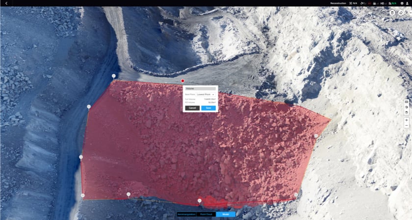
For stocktake volume measuring, drones typically use a modeling process called photogrammetry to create a 3D map of your site and find the dimensions of your stockpiles. UAV photogrammetry involves taking multiple images of a feature from different perspectives or lines of sight, and stitching them together with mapping software. Accurate measurements can then be deduced from these models. While many traditional drone surveying jobs require hundreds or even thousands of aerial photographs, you may need only a few images for a single stockpile, depending on its size.
In some cases, worksites may also use a modeling technique called light detection and ranging, or LiDAR for short. LiDAR uses pulses of light, rather than digital images, to assess your stockpile. Traditionally, the higher cost and heavier weight of LiDAR payloads has made it less common for stockpile measuring, but this might be changing with the release of the Zenmuse L1, our first LiDAR payload.
With that said, the typical volume measuring process will look like this:
Photographing a stockpile
To begin you’ll need to capture aerial images of the larger worksite before focusing on the stockpiles. These images give a context for the stockpile and help to create an accurate scale. Images should be matched against GPS coordinates for the best results.
Using mapping software
From there, all you need to do is upload your images into the appropriate drone software and create 3D models. To use a model to calculate accurate stockpile volume, you’ll first need to plug in the area’s reference level. The reference level represents the ground or floor of the site and is the baseline from where stockpile volume is recorded. In some cases, your software will be able to identify the reference level automatically. This will give you an accurate volume measurement and allow you to easily see growth or change in a stockpile.
Calculating tonnage
Of course, simply knowing the accurate volumes of your stockpiles may not give you all of the information you’re looking for, such as tonnage. Luckily, these metrics can be closely converted with an online calculator. Simply plug in the material you’re measuring and you’re on the right track.
The right drones and payloads for mining and construction
For accurate stockpile volume measurements, you’ll need a drone that can assure accuracy down to the centimeter. The Matrice 300 RTK’s rapid speeds and long-lasting batteries make it a workhorse on larger sites — perfect for companies with multiple locations or stockpiles. It can also mount up to three payloads at once, so it’s easy to collect data with as few flights as possible.
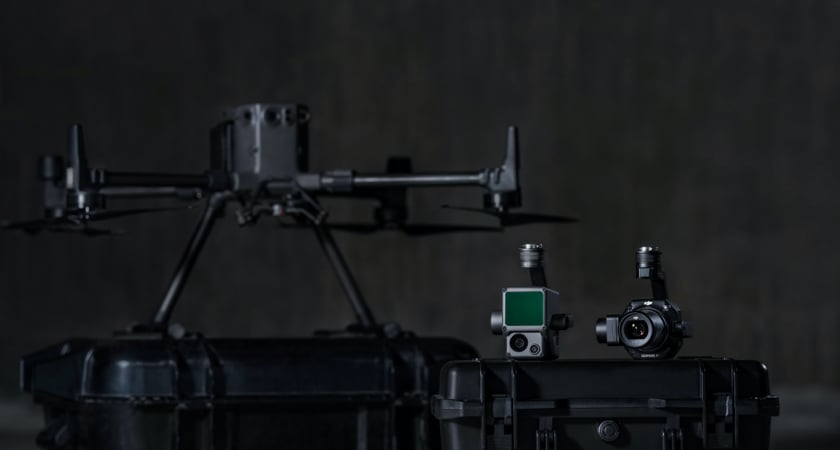
Whether you’re performing photogrammetry or LiDAR mapping, DJI also has the payload you’re looking for. The Zenmuse P1, our flagship photogrammetry payload, comes equipped with a 45-megapixel full-frame low-noise high-sensitivity sensor with interchangeable 24/35/50mm fixed-focus lenses.
For surveying jobs that require LiDAR, meanwhile, we recommend the Zenmuse L1. With high-accuracy IMU and dense foliage penetration at a reasonable price point, this payload allows you to survey even the most complex terrain. Both cameras easily integrate with our premier mapping software, DJI Terra.
Sources:
https://www.stockpilereports.com/stockpile-measurement-methods-that-work/