
It’s a perfect California day, the ground bathed in golden light, when Oscar Miguel lifts the Inspire 2 off the ground – the San Jacinto Mountains framing a perfect backdrop.
The mission? Mapping utilities for the Soboba Band of Luiseño Indians. The Band’s Tribal lands are on the lower reaches of those mountains, across the river from the city of the same name. The Band has engaged a project management and engineering firm from San Diego called C2 Group to help it create an accurate baseline locating utilities and infrastructure that are over, adjacent to – and even under – a specific length of road.
Whether it’s ground-penetrating radar, the planning and installation of Electric Vehicle charging stations, or data acquisition by drone – C2 has earned a reputation for excellence. Miguel is the company’s VP of Operations.
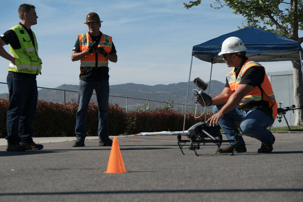
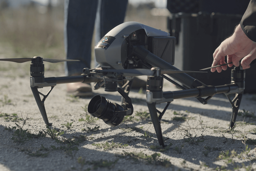
C2’s Oscar Miguel (R) prepares for a flight over the Tribal Lands of the Soboba Band of Luiseño Indians with a DJI Inspire 2. Image courtesy of C2 Group.
His own background in construction management, commercial banking and insurance makes him perfectly suited for the boardroom (his LinkedIn profile shows him in a tailored suit). But he’s happiest out here, swapping his white collar for blue.
“I have about 20 suits and 50 pairs of shoes that I no longer wear,” he laughs. “Instead they’ve been traded for hiking boots and cowboy boots. But what a beautiful way to earn a living, right?”
Miguel and C2’s other pilots make skilled flying and data acquisition look second-nature. The checklist and Standard Operating Procedures are known by rote at this stage – the result of training, daily operations, and a company-wide ethos of professionalism. It’s indicative of how drones have become a critical component in C2’s technological toolkit.
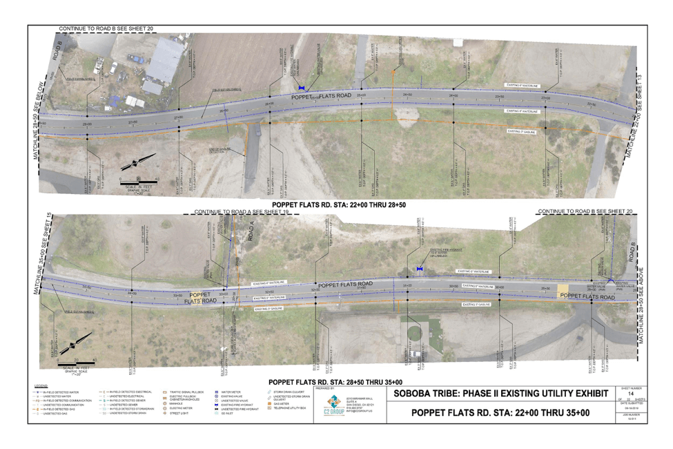
The company is also highly adept at layering drone-acquired information with other types of data – including what C2 gathers via Ground-Penetrating Radar (GPR) and Radio Detection. In fact, that’s the kind of work the firm is carrying out here, determining precisely where below-ground water pipelines are located with respect to the road and nearby utilities above ground. This job involves mapping every key feature, every twist and turn, over a six-mile portion of Tribal Land that encompasses seven different roads.
“They brought us in to help them identify their utilities and all arterial roadways,” explains Tatiana Friesen, C2’s Chief Operating Officer. “We were really helping them do more verification – so we used the drones specifically to map and identify the utilities.”
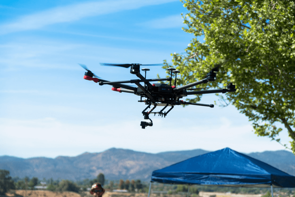
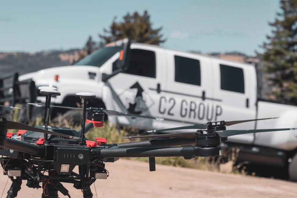
A DJI M600 Pro on duty for C2 Group during a long-term project on the Tribal Lands of the Soboba Band of Luiseño Indians. Image courtesy of C2 Group.
In fact, the seamless use of drones and integration of the data they acquired were key to not only this project – but many C2 now routinely takes on.
A Model to Follow
If you’re thinking of starting a drone program – or perhaps scaling an existing operation – consider learning from the C2 Group. The firm’s experience with developing a thriving program from scratch is a textbook example in how to do things right.
Back in 2016, the company didn’t have a single drone in its inventory. But it had been contracted on a utility project to replace wooden power poles with steel ones. Part of the job involved documenting the older assets, along with the newly installed poles.
Here are some tips shared by the C2 Group:
- Start small
- Emphasis on education
- Software
- Data handling
- Leveraging expertise
- A very useful tool
- Pay it forward
Start Small
The Women-Owned Small Business was aware that getting a view from above would be helpful, but with zero practical drone experience it didn’t make sense to simply dive in – especially for a company that likes to collectively make decisions based on data and Best Practices. Chief Technical Officer Brandon Del Priore says C2 decided to explore the possibilities with a minimal investment: It purchased a Mavic Pro to test its capabilities.
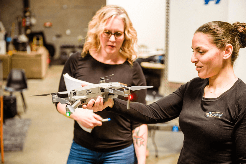
C2 Group’s VP of Program Development, Nicole Alarcon, watches on as C2 President and Co-Founder Omneya Salem inspects a DJI Mavic 2. Image courtesy of C2 Group
After about a week of capturing georeferenced images, C2 could see the value a drone could provide. Plus, there were other jobs on the table involving mapping the firm felt could benefit from a UAV. Within weeks, it purchased an Inspire 1 and Inspire 2.
“After our initial use-case scenario, we began using the Inspire 1 and Inspire 2 for mapping projects on parking lots for civil design,” says Del Priore. “And were able to derive enough quality mapping data that was acceptable for the design teams – and was cheaper, faster and easier than using a traditional survey method.”
 But it wasn’t just the ability to capture quality data. It was the ability to capture *meaningful* data that could be integrated into the project as a whole.
“The drone work is near and dear,” explains Tim Tipping, Director of Program Management. “I used to design the (replacement) structure. Seeing that, and that it can actually save people’s lives, is very special to me. People say they take on life-changing stuff, but this literally is that.”
As a contractor, C2 had to ensure it was adhering to the geospatial data standards outlined by the American Society for Photogrammetry and Remote Sensing (ASPRS). That meant ensuring that the drone data could mesh with what had been gathered by traditional survey techniques. It did – and it does.
We’ve been able to consistently validate the drone data against the survey data and create very high-resolution maps at incredibly large scale,” says Del Priore.
That granularity is important to C2 and its clients.
When the company began flying its M600s it used the Sony A7R II – capable of capturing 42.4 megapixel images. It now deploys the Sony A7R IV, which captures 61 megapixel files. When those files are overlapped, such as with photogrammetry missions, the results are phenomenal.
The data captured by drones and by Ground-Penetrating Radar was used to accurately locate existing utilities – whether above or below ground. Image courtesy of C2 Group.
And its fleet? That keeps expanding as well.
As of March of 2020, C2’s stable had grown to include an additional 18 multi-rotor drones, primarily from DJI, and a VTOL in its hangar.
But it’s not the cost or complexity of the different models that count. It’s what they can dofor the client. And to fully ensure the drones are capturing the best possible data, C2 ensures that it’s people have the best possible training.
Emphasis on Education
Early on, C2 recognized the importance of emphasizing quality training. The firm was fortunate enough to have a working relationship with an attorney who was not only a licensed private pilot and flight instructor – but also a professor of drone technology at a local university. Rather than send staff out to train at an external school, it engaged him to conduct in-house training. A bonus of this approach – often lost when using an external provider – is that the instructor has been able to keep C2’s staff current on regulatory changes as legislation evolves.
In those early days, the Federal Aviation Administration required Section 333 Exemptions in order for C2 to carry out commercial operations. From the moment the FAA instituted Part 107, C2 pilots began studying for and writing the exam. All of those who fly are Part 107 certified, and all flights and hulls are well-insured.
Also worth noting is the fact that C2 continues developing skills even for those pilots who fly on a regular basis. They’ve kept that original Mavic Pro, as well as the early Inspire 1 and Inspire 2 for this purpose, though C2 says all of those vehicles are approaching retirement age.
“We assign a great level of importance to ensuring we are well-trained,” says CTO Del Priore. “That we have a very rigorous, ongoing program.”
C2 Group’s Chief Technical Officer, Brandon Del Priore, has been involved in the firm’s drone acquisitions since the beginning. Image courtesy of C2 Group.
Software
C2 also quickly identified that integrating drones in its regular operations would require more than training and more than hardware. It demanded software with specific capabilities. DJI’s own software suite is highly capable, but C2 wanted something additional, proprietary, and tailored to its own specific fleet and operational requirements.
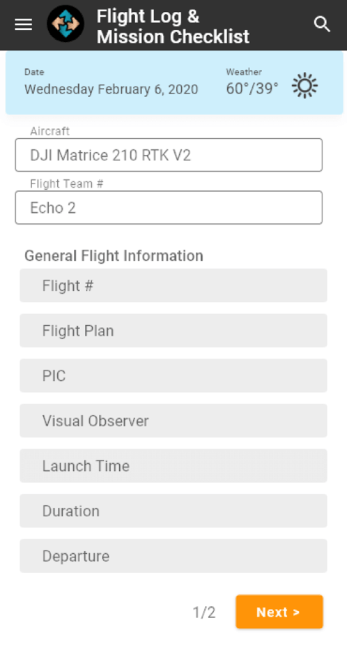
And so, using its in-house software team, the company developed its own iOS and Android apps.
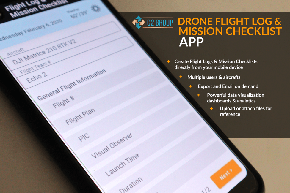
C2 graphic and app screen grab illustrate the many features of their fleet and flight management app, which was coded in-house. Image courtesy of C2 Group.
“That has all our pilot flight logging and all of our inspection reports and everything rolled into one location,” he explains. “And that feeds back into a database with dashboards and live reporting and metrics: Total flight time, maintenance cycles, client, location – any repeatable that we capture over time.”
In addition, the app contains C2’s Standard Operating Procedures, its complete flight manual, plus sections for maintenance and training. As well as having the data collected on C2’s own servers, this system serves the company well as it continues to scale.
A screen capture from C2’s app, which tracks every single flight the firm carries out.
Though it frequently dispatches its own pilots to other states for contracts, C2 also works with experienced pilots and engineers elsewhere in the country when required. By having those external pilots use the company’s app, they can receive an instant snapshot back at San Diego headquarters of what any pilot is doing at any given point in time – whether they’re across town or across the country.
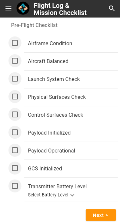
C2’s app includes a pre-flight checklist - where every item requires acknowledgement. Image courtesy of C2 Group.
And because C2 now captures real-time data with two apps – the DJI app and its own – it can overlay these datasets to obtain an even clearer view of how individual pilots are flying, including identifying areas where the company can help them further refine skills.
Data Handling
Because C2 has deep experience with data capture and analysis, it prioritizes how it handles that data on behalf of its clients. The protocol can change depending on the job or client requirements, but a clear plan and path for data handling and security is always part of the workflow. This is a *far* more regimented and secure process than simply copying data off cards.
C2 has even developed a protocol for updating the firmware on each drone. DJI’s constant software improvement can occasionally mean pilots who aren’t on top of every twist and turn have discovered an update is required only after booting up in the field. That’s not only lost time, but also – at least potentially – a risk there could be a hiccup. That’s why C2 tracks all updates, and performs all of them in the office using a single dedicated computer.
“Any firmware updates – we have that done through one piece of hardware specifically,” says Del Priore. “We test to ensure updates are stable, and we make sure all our hardware is compatible with any firmware.”
Leverage Expertise
As C2’s expertise with drones grew, so too did its knowledge of strengths of certain models. For example, it discovered that the Matrice M210 was particularly suited for work around high-voltage transmission lines. The industrial drone, in the firm’s experience, seemed almost immune to any interference those lines threw at it.
“We predominantly use the M210 for work around high voltage power. They are much more robust and can deal with magnetic interference,” says Del Priore. Some other models, they discovered, can be prone to weaving up and down due to the prominent sine wave emitted by the lines. The M210 was rock solid.
“We’re (also) using those with RTK units, so even if we’re in a GPS-denied situation we still have great communication.”
One of C2’s DJI M600s in the field, with a C2 vehicle in the background. Image courtesy C2 Group.
As word spread about C2’s expertise with drones, it wasn’t long before the company was approached specifically because it had this knowledge. One of its clients was exceptionally large – with a very long-term inspection contract as well as an advisory role for how to most effectively deploy teams operating drones. C2 is not at liberty to share details, but the company was large enough that it could have hired any firm in the United States. It chose C2 Group.
That growing reputation and knowledge base continues to lead to new contracts. The company now has teams working a major inspection contract in Arizona, part of a federal project on fibre optic installation that involves installation both above and below ground.
And while C2 has five full-time pilots, most of these individuals came with backgrounds in engineering, drafting or related fields. That means when they’re not flying, they can return to the office and carry out other highly-skilled work.
“So one week they can fly drones, the next week they can be back in the office doing work for the (fibre-optic) layout,” explains Del Priore.
A Very Useful Tool
Despite the fact C2 has a large fleet of Enterprise drones, it’s not a UAV company. Its core business is project management and engineering. The work carried out by drones is not an end in itself – only a way to supplement the company’s core work.
“Most of the projects we work on, we’re using the drone as a tool as part of a suite of tools that serve a function within an individual project,” says Del Priore.
It’s been four years of learning, scaling, purchasing and integrating the data acquisition of UAS into the C2 workflow. The company is now so respected in this field that others have consulted with them on how best to exploit this technology for differing use-case scenarios. Others know that C2 knows how to capture and interpret data into results that are clear and actionable.
“There are many drone companies that will collect the data and give it to you,” says Chris Friesen, C2’s Chief Estimator. “But they don’t care what it is or how it is delivered. We understand the actual end-deliverable.”
Brandon Del Priore, in particular, has learned a lot during this period. And he has some advice for anyone thinking of incorporating drones into their workflow.
“Research, research, research,” he says. “And make sure the equipment you’re interested in purchasing meets the requirements of the teams that have to use the data that comes out of them.”
And – perhaps the most useful knowledge of all:
Know your market, know your client, and know your capabilities – so that you don’t overpromise and under-deliver when the time comes to actually take care of a project.”
Pay it Forward
In early March, some members from C2 Group were back on the Tribal Lands of the Soboba Band of Luiseño Indians. Once again, with the majestic San Jacinto Mountains in the background, the team had brought along an Inspire 2 drone.
This unit was newly refurbished, and ready for an important and ongoing task. One that did not involve data acquisition for C2.
This Inspire 2 is about to take on a long-term mission.
Earlier, the Soboba Band administration had requested C2’s assistance with a grant proposal submission. The administration felt its own engineers, and perhaps others, would benefit from having a drone on hand to train with and carry out some future missions of benefit to the Reservation.
C2 was happy to help.
“Internally at C2, we decided that we could make that happen,” says COO Tatiana Friesen.
And so that Inspire 2 left C2’s hands that day and became the property of the Soboba Band – the seeds with which its own drone program and expertise will grow over time.
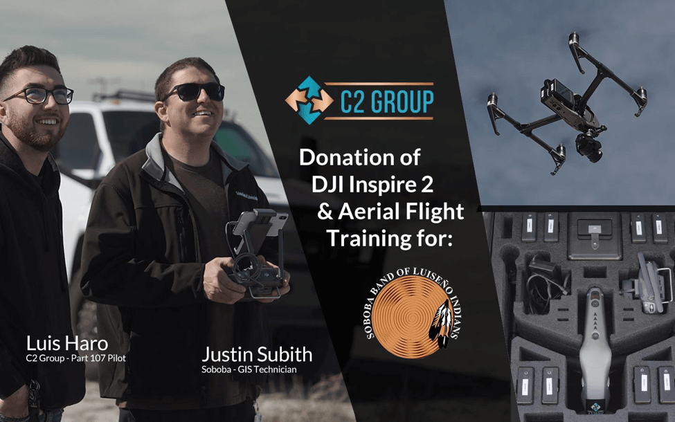
C2 Group’s LinkedIn post announcing the donation of the refurbished Inspire 2 to the Soboba Band of Luiseño Indians.
“They were very excited, I know Justin [Subith] was super-excited about being able to integrate it with his workflow,” says Friesen. “And from a personal standpoint, they’re really good people and we were looking to support them.”
What goes around, comes around.
Just like a rotor.
The Future
From the company’s first purchase in 2016 through to today, drone technology has developed at a dizzying pace. Innovations like Real Time Kinematic (RTK) sensors have provided geospatial accuracy that can be measured in centimetres. New cameras – by DJI, Hasselblad, Sony and others – now provide ultra high-resolution imagery for inspections and photogrammetry. The cost of LiDAR and FLIR sensors has dropped while technology has improved. New applications by third-party developers have brought even more use-case scenarios to operators.
They have embraced every step of this technology – and put it to work for their clients. That’s the C2 way.
“We all have the same spirit, the same attitude – that we’re going to work as long and as hard as it takes to provide perfection,” says Del Priore. “We don’t ever, no matter how tired anybody might be, provide something that’s sub-par. I think that’s really what it is: To make sure that a client’s deliverables are perfect.”
It’s a philosophy the company’s CEO and Co-Founder, Omneya Salem, sums up in just three words.
“We’re very passionate,” she says.
And continuing to grow. The company is now operating not only in California, but on a variety of projects in Washington State, Oregon, Arizona and more – with drones contributing at least one layer of data (and often more) in pretty much every project.
It’s a vantage point that provides a unique perspective on the future:
I think in the Big Picture, drones are always going to be an incredibly useful tool for multiple lines of business that we support,” says Del Priore.
“As we move forward,” he asks, “where is drone technology headed?”
It’s a good question.
Brandon then answers it...in just four words.
“The sky’s the limit.”
We could not agree more.

-2.png?width=300&name=Insight%20blog%20featured%20image%201140X660%20(3)-2.png)
.png?width=300&name=HS%20-%20Featured%20Images%20(7).png)
-1.png?width=300&name=HS%20-%20Featured%20Images%20(5)-1.png)