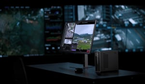

DJI FlightHub 2 Analyzer is now officially live, introducing features such as design file import, timeline, measurement calculation, and automated workflow, bringing a powerful new solution to Architecture, Engineering, and Construction (AEC) professionals.
Driving Digital Transformation in AEC
In the construction industry, traditional project management faces four persistent challenges: limited site access, high operational costs, inconsistent deliverables, and ineffective data use. For Architecture, Engineering, and Construction (AEC) professionals, overcoming these pain points requires breaking through legacy workflows, and digital transformation has become a strategic imperative.
To meet the evolving needs of the industry, DJI has launched a dedicated AEC of FlightHub 2, featuring the newly released Analyzer module tailored for construction applications.
When integrated with DJI Dock 3, FlightHub 2 enables a closed-loop workflow from automated drone data capture and cloud-based 3D modeling to advanced analysis. This all-in-one drone solution directly addresses critical industry needs, including visual and schedule progress tracking, site safety oversight, regulatory compliance verification, and operational efficiency enhancement.
Design File Import: Precise Alignment Between Design and Reality
In construction project management, design blueprints carry critical vector data, construction specifications, and target parameters. With the new blueprint import feature in FlightHub 2, users can upload design files in PDF or DXF format and align them with drone-generated 3D models through flexible coordinate transformation tools, such as custom parameters, control point matching, or manual pin marking. This allows for the precise overlay of blueprints and reality capture models, making it easy to identify deviations and resolve issues early in the project lifecycle.
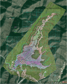
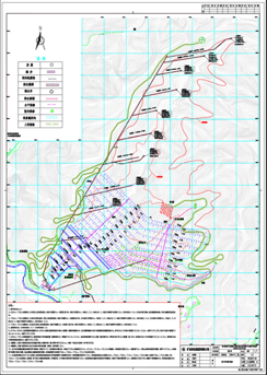
Design File Import and Reality Model
For example, in tailings dam monitoring projects, intelligent overlay of design blueprints and reality models enables engineers to visually compare the overall dam contours and sub-dam boundaries against design specifications. It also allows for real-time tracking of flood line changes and accurate verification of key structures such as drainage shafts, significantly improving quality control while providing reliable data support for project safety.
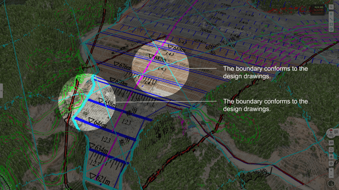
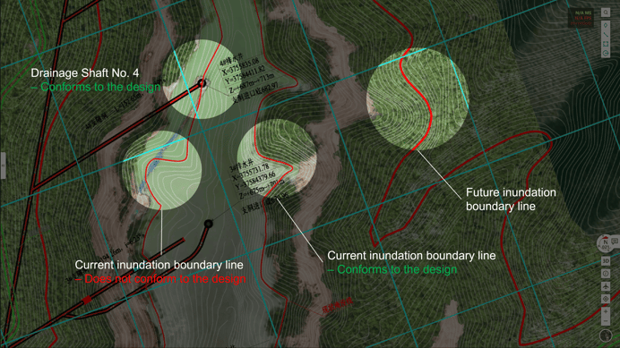
Design File Import into FlightHub 2 and Overlaid with 3D Model of a Tailings Dam
Timeline: Visualize Project Progress Over Time
Using consistent flight paths across different time points, drones can capture large volumes of visual data, including RGB, infrared, panoramic images, and both 2D and 3D models. Faced with such data abundance, how can project teams make better use of it to enhance management efficiency?
FlightHub 2 introduces the Timeline feature, enabling users to browse drone-collected datasets chronologically. This allows for comparisons from the same perspective over time, making it easier to track changes in localized areas and gain a clear view of project progress.
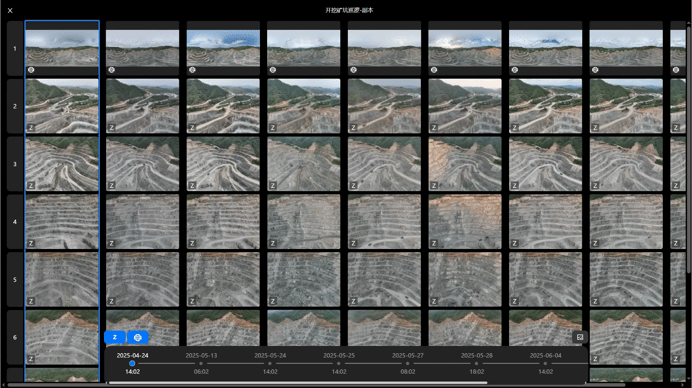
Timeline Feature in FlightHub 2

May 13 | May 24 | May 27
Measurement Calculation: Multiple Modes to Support Precise Project Management
FlightHub 2 supports cloud-based modeling and delivers high-resolution reality capture, enabling powerful digital measurement capabilities for construction and infrastructure projects.
1. Basic Measurements
Distance: Horizontally Projected、Vertically Projected、Spatial Distance
Area & Perimeter: Spatial Area、Horizontally Projected Area、Spatial Perimeter、Horizontally Projected Perimeter
Altitude Difference: between selected endpoints
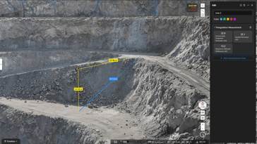
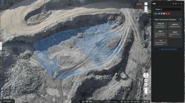
Triangular Measurement Area Measurement
2. Gradient Calculation and Extract Cross-SectionsGradient Calculation: Measure gradient angle, slope percentage, and slope ratio; supports multi-segment slope measurement.
Extract Cross-Sections: Compare cross-sections across multiple timeframes and align them with design drawings for deviation analysis.
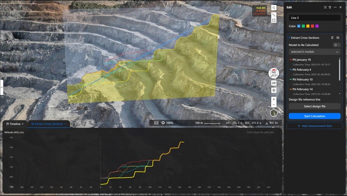
Cross-section comparison across multiple models to extract structural data
3. Volume MeasurementFlightHub 2 supports volume calculations based on 2D models, 3D models, and point cloud models, enabling users to measure changes such as cut volume, fill volume, volume difference, and total volume. By extracting structured data, it empowers precise, data-driven progress tracking and quantity management in construction projects.
3.1 Current model volume calculation:- Supports custom baseline definition, including: Triangulated Mesh Surface, Endpoint Fitted plane, Custom Horizontal Plane, or comparison between two models.
- Supports importing 3D design files for direct calculation.
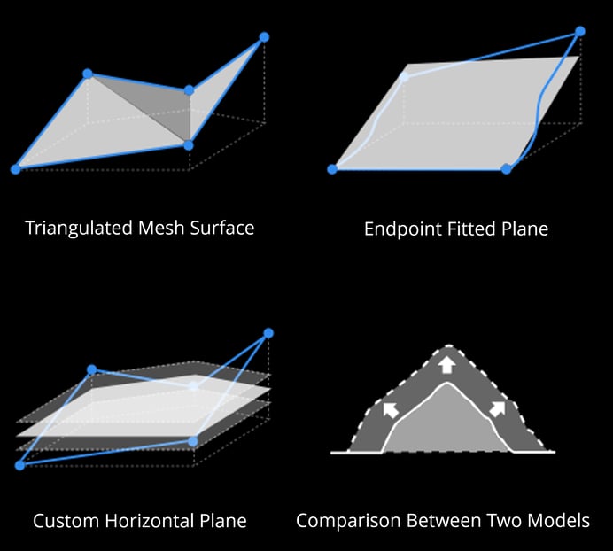
Single-period model volume measurement
3.2 Multi-Phase Model Volume Change Calculation:
By overlaying models captured at different times, users can accurately calculate cut and fill volumes to support construction management.
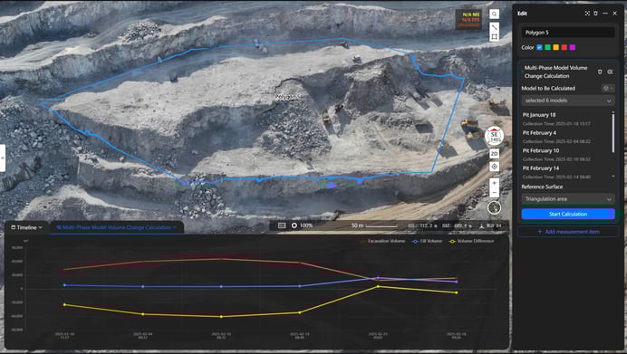
Multi-Period Model Comparison
In addition, FlightHub 2 allows users to customize measurement reports. This allows the selection of specific measurement types, custom cover images and company logos, header and footer display, as well as scheduled report generation and delivery.
FlightHub 2 measurement tools deliver visualized and structured data outputs that support digital decision-making across progress tracking, quality control, and cost estimation, driving construction project management toward greater precision and intelligence.
Automation: From Capture to Insight, All-in-One Flow
As DJI's enterprise software platform, FlightHub 2 fully leverages the synergy between hardware and software. With its drag-and-drop automated workflow builder, users can configure end-to-end processes—covering data capture, modeling, measurement, analysis, and report generation—on a recurring schedule, with minimal manual intervention.
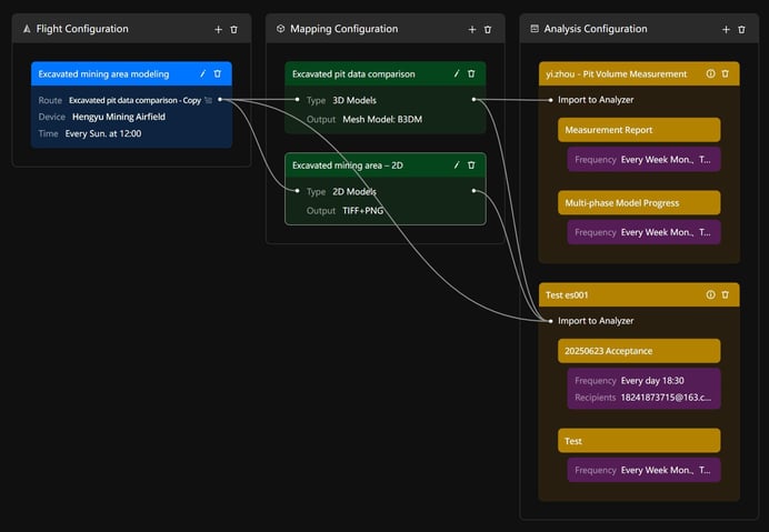
Automated Workflow Configuration
The FlightHub 2 Analyzer is well-suited for vertical industries such as infrastructure development, natural resource management, and mining. It also empowers sectors like security, emergency response, inspection, and urban management with powerful data analytics capabilities.
By delivering smarter, more efficient, and precise solutions across industries, FlightHub 2 empowers the construction sector’s transition toward data-driven operations and digital transformation.