
For more than a decade, DJI has been known for its industry-leading drone technology, especially in the commercial drone sector with DJI Enterprise. However, in recent years, DJI Enterprise has also made remarkable updates to its software portfolio with the introduction of the cloud-based fleet and mission management platform Flighthub 2 and continuous upgrades to its UAV 3D modeling software, DJI Terra.
Today, DJI takes another step forward in providing professional survey users with end-to-end solutions introducing DJI Modify, the latest innovation from DJI set to reshape the landscape of 3D model editing.
Representing DJI's inaugural foray into intelligent editing software, DJI Modify boasts a streamlined and intuitive interface that simplifies the digital model editing process. When coupled with a DJI Enterprise drone and DJI Terra, it delivers a comprehensive solution, seamlessly bridging aerial surveying, modeling, and model editing. This all-in-one platform caters to the diverse operational needs of industries such as surveying and mapping, urban planning, firefighting, and emergency response, among others, ensuring the efficient sharing of models to meet the demands of a dynamic landscape.
Here is everything you need to know about DJI Modify:
Seamless Workflow with DJI Terra
DJI Modify seamlessly integrates with DJI Terra, forming a comprehensive solution for aerial surveying, modeling, and efficient model editing. The workflow is streamlined, ensuring a hassle-free transition from modeling to model editing, ultimately meeting the operational needs of industry professionals across various industries.
Launching DJI Modify within a DJI Terra 3D modeling project is a one-click process. This integration streamlines the model editing process, providing efficiency and an end-to-end solution. DJI Modify's switch in DJI Terra automatically generates files for model editing, including pre-identified objects and pre-processing of the model.
Work Efficiency & Smooth Operations
DJI Modify's streamlined interface fosters intuitive interaction, allowing users to get started rapidly without extensive familiarization.
The software swiftly performs model file operations and editing tasks, such as automatic texture repair and batch flattening of vehicles, reducing the model editing workload.
Thanks to advanced model display technology, DJI Modify supports viewing and editing high and low-quality models in a single interface, providing flexibility for various scenarios.
Efficient 3D Model Retouching
DJI Modify excels in repairing drone-captured 3D models, addressing issues like floating parts, water surface anomalies, mesh irregularities, and texture problems. Here are some examples of how DJI Modify can easily perform common modeling repairs:
Floating Parts Removal: This function allows for the easy removal of floating parts with multiple selection methods, streamlining the cleaning process.
Flattening: Users can flatten selected areas, ideal for scenarios like removing vehicles from a parking lot or smoothing out specific areas of the map.
Texture Repair: The Texture Repair function enables precise erasing, cloning, and repairing of textures, ensuring a seamless and aesthetically pleasing result.
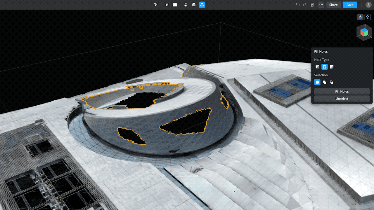
Fill Holes: The Fill Holes tool utilizes machine learning to generate new mesh and fill in gaps in thin structures or areas with insufficient overlap.
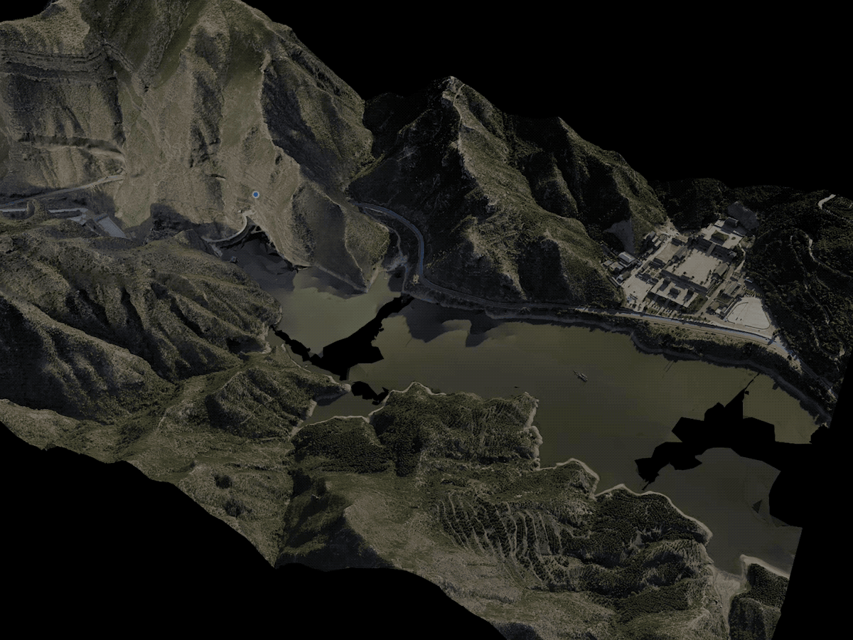
Water Surface Repair: DJI Modify smartly repairs water surfaces, allowing users to adjust the range, height, shape, and position for optimal results.
These repairs will enhance the final model deliverables, allowing architects, engineers, surveying professionals, urban planners, or other professionals, to have a smoother digital model to work on and make accurate decisions.
Cloud Sharing, Quick Delivery
Collaboration between teams plays a huge role in large-scale projects, especially when we talk about infrastructure or urban planning. Aerial survey data and 3D model files usually require specific software such as DJI Terra to view, therefore hard to share between teams.
To overcome these challenges, DJI Modify facilitates rapid rendering and exporting of models in various formats compatible with DJI Terra and third-party software. The processed models can be quickly shared through the cloud, enabling stakeholders to view them online using a web browser on their mobile device or computer without installing additional software1.
Test DJI Modify Now!
To experience the power of DJI Modify, users can apply for a trial or inquire about purchasing details. The trial application process is simple and ensures a six-month free trial license, allowing users to explore the software's capabilities. For those interested in purchasing, DJI Modify is available through authorized dealers.
In conclusion, DJI Modify is not just a software tool; it's a game-changer in the world of 3D model editing. With its seamless workflow, streamlined interaction, and efficient repair capabilities, DJI Modify empowers users to create and share stunning and complex 3D models with unparalleled ease.
1. This feature is not yet available outside of China. It is expected to be released to Global customers in Q2-2024.

-2.png?width=300&name=HS%20-%20Featured%20Images%20(2)-2.png)

