
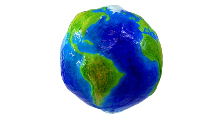
Is the Earth really round? While the answer should seem obvious, it’s really not as simple as you may think. To be classified as a perfect sphere, an object must be completely round and symmetrical, able to be diced down the middle from any direction and create two equal halves. Earth — with its irregular shape, high plateaus and deep cracks in the ocean floor — is anything but.
So what shape is the Earth, and how does its classification impact surveying jobs? To answer that, you’ll need to understand the difference between a geoid and an ellipsoid, two ways of modeling designed to map out the imperfections of our planet.
So what is an ellipsoid?
An ellipsoid is, in essence, an imperfect sphere. The name comes from the word “ellipse,” which is used to describe a similar alteration to a circle.
Unlike spheres, the length, width and height of an ellipsoid do not all have to be identical. However, any cross-section plane of the shape must still be either an ellipse or a circle. According to Encyclopedia Britannica, this is explained through a mathematical equation that takes into account three different perpendicular axes that all intersect in the shape’s center:
x2/a2 + y2/b2 + z2/c2 = 1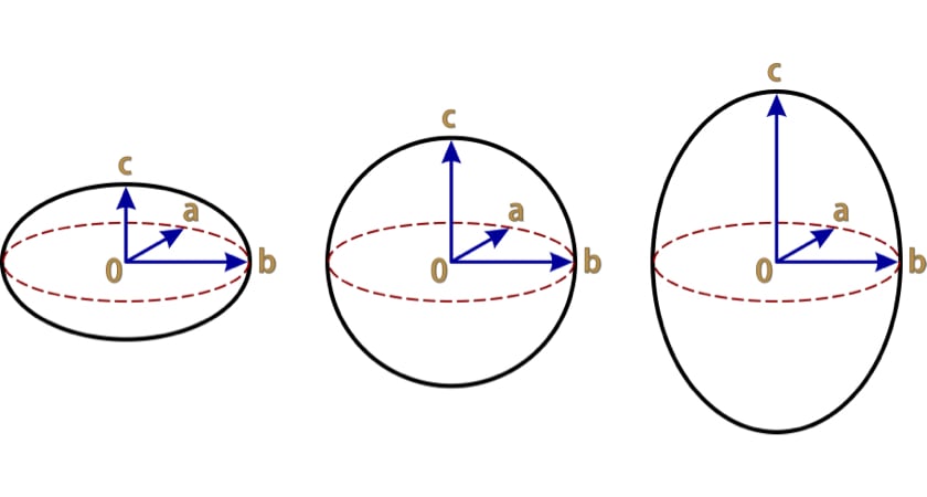
If a, b and c are all equal, the shape is a sphere. If two of the three values are equal, the shape is a spheroid — sometimes also known as an ellipsoid of revolution, because any cross-section plane of the shape would be an ellipse. Spheroids are divided into two categories. If the two equal values are greater than the third, the shape is an oblate spheroid. Meanwhile, if the spheroid’s single value is greater than the two equal ones, the shape is a prolate spheroid.
Ellipsoids and the shape of the Earth
Scientists and mathematicians use the ellipsoid model to more accurately define the shape of the Earth and other planets. An ellipsoid that offers a close approximation of a planet is known as a reference ellipsoid, according to the University NAVSTAR Consortium (UNAVCO). The specific measurements used to model Earth are known as the earth ellipsoid.
While Earth may appear to be a perfect sphere in satellite photographs, this is not the case. Instead, the planet is far wider at the equator and flattens the closer you are to each pole — or has a single shorter axis. In other words, Earth is a close approximation of an oblate spheroid ellipsoid. While it’s not perfect, the earth ellipsoid has many uses, including plotting GPS coordinates and flight paths. In coordination with data from a geoid model it is also essential for surveying jobs.
...And a geoid?
While thinking of the Earth as an ellipsoid, rather than a sphere, certainly gives a more accurate understanding of the planet’s shape, it still leaves a lot to be desired. The ellipsoid shape is still completely smooth, failing to take topography into account. This is why reference ellipsoids are typically referred to as being the “best approximation” of a planet. For a more accurate picture, you need to use a geoid model.
Geoid models use a measurement called Mean Sea Level to give a fuller representation of the way the Earth’s surface varies in elevation. Mean Sea Level is the elevation of the planet’s sea level surface if the water were completely flat — or without tides and currents. Mean Sea Level is useful for models because water responds to the Earth’s gravitational pull, according to NOAA. Places where gravitational forces are stronger — and the Mean Sea Level higher — indicate more mass beneath the surface. Likewise, a lower Mean Sea Level also indicates dips in elevation on the ocean floor. Mapping these measurements typically results in gradual undulations all across both oceans and landmasses, according to the U.S. Geological Survey.
Notably, geoid modeling is typically conducted on a more local level than the overarching earth ellipsoid model. The U.S., for example, currently uses the North American Vertical Datum of 1988 or NAVD88. The National Geodetic Survey, however, is working on an updated model that takes advantage of GPS data. Throughout the years, the NGS has also crafted several experimental and hybrid geoid models that take into account
How does the difference between an ellipsoid and a geoid model affect surveying?
As a surveyor, you want to ensure you’re working with precise data that is measured consistently across the entire site. While the overall shape of the planet may feel like it has a relatively small impact on a single surveying site, the data available from geoid models is essential.
In particular, ellipsoid and geoid models are used to establish the vertical datum of a site. In partnership with calculations like the ground sample distance, the vertical datum is paramount to aerial photogrammetry and surveying in general. This unit of measurement represents the zero point of elevation for wherever you are working — or the point from which you map topography.
While surveying is typically done based on geodetic datums, which is calculated based on a geoid model, there are actually two different types of vertical datum. The other, tidal datums, are calculated by measuring the changes in water surface levels over a period of time. Since most surveying is land-based, this form of measurement is usually not applicable.
Using vertical datum to keep data consistent
A big part of maintaining accuracy throughout a surveying job is ensuring that you’re using the same vertical datum for every part of the project. That means any part of the site that sits on a different datum needs to be converted to match. Luckily this can be done with a simple formula that uses information from both geoid and ellipsoid models:
Ellipsoid height - Geoid height = Orthometric height
The ellipsoid height is the difference between the earth ellipsoid and your chosen coordinate on the Earth’s surface. Because GPS coordinates are based on an ellipsoid model, no additional calculations will be necessary to find this number if you are using a GPS receiver. Geoid height, meanwhile, is the offset value between the geoid model you’re referencing — such as the NAVD88 — and the earth ellipsoid.
The result of plugging these numbers into your formula is the orthometric height. This is the number that must stay consistent throughout all of your data.
The right drone and payloads for accurate measuring
Now that you understand how to use ellipsoid and geoid models to ensure to-the-centimeter accuracy, it’s time to upgrade to equipment that can complete the job. Look no further than the Matrice 300 RTK. With rapid speeds and long-lasting batteries, this drone goes where you need it to. The ability to mount three payloads at once also makes it easy to collect data with as few flights as possible.

Whether you’re performing photogrammetry or LiDAR mapping on your next site, DJI also has the payload you’re looking for. The Zenmuse P1, our flagship photogrammetry payload, comes equipped with a 45-megapixel full-frame low-noise high-sensitivity sensor with interchangeable 24/35/50mm fixed-focus lenses. Combined with superior data quality management and you’re ready to map out every little detail.
For surveying jobs that require LiDAR, we recommend the Zenmuse L1. With high-accuracy IMU and dense foliage penetration at a reasonable price point, this payload is perfect for surveying any terrain. Both cameras are designed for easy integration with our mapping software, DJI Terra.
Sources:
https://www.unavco.org/education/resources/tutorials-and-handouts/tutorials/elevation-and-geoid.html
https://www.propelleraero.com/blog/geoids-vs-ellipsoids-whats-the-difference/
https://www.britannica.com/science/ellipsoid
https://oceanservice.noaa.gov/facts/geoid.html
https://geodesy.noaa.gov/datums/newdatums/index.shtml
https://www.gpsworld.com/a-look-at-ngs-experimental-and-hybrid-geoid-models/
https://www.vims.edu/research/units/labgroups/tc_tutorial/tide_datum.php


-2.png?width=300&name=HS%20-%20Featured%20Images%20(2)-2.png)

