
Drones equipped with cameras give companies an extra pair of eyes in the sky, providing a new perspective on operations happening on the ground. Across industries as varied as construction, emergency services, agriculture, and utilities, drones are adding value.
The sensor technology on uncrewed aerial vehicles (UAVs) is constantly evolving, meaning that these crafts aren't just taking standard snapshots and videos. One of the latest developments in UAV loadouts involves the use of ever-more-advanced light detection and ranging (LiDAR) systems.
By deploying a drone equipped with a LiDAR sensor, companies can take more accurate aerial readings — creating 3D models with centimeter-level accuracy and detecting features that would be invisible to less sophisticated methods.
Far from being a niche technology area, LiDAR is reaching all types of industries that need mapping and geospatial data collection services. By tracking the latest uses of LiDAR sensor drones, you can determine if these useful UAVs fit into your business's plans.
What is LiDAR?
LiDAR is a form of remote sensing technology. Rather than employing conventional photo cameras, LiDAR sensors send out rapid laser pulses and capture the responses — using those data points to map out an area with a great deal of both precision and accuracy.
The LiDAR system creates a point cloud with the data pinging back from the objects on the ground. These points are the raw material for 3D models. While assembling those models requires specialized software — and experts who know how to use it — the process is relatively fast, and generates high-quality maps with small file sizes.
It should be noted, though, that these 3D images don't have photographic detail. For instance, the laser pulses themselves won’t give you the colors of items on the ground. That data will have to come from an alternative source, such as an additional sensor.
LiDAR technology has seen a few developments in recent years — namely, the sensor modules are becoming more affordable and significantly lighter. This has allowed the rapid evolution of LiDAR drone systems, with new models emerging and allowing companies to apply the technology to more use cases.
Rather than being the work of a single company, LiDAR systems are in development by multiple providers, including Livox and Velodyne. System integrators such as GreenValley, YellowScan, Emescent, and LiDARUSA are responsible for turning the tech components into commercially usable modules.
With these options in front of them, some organizations may consider adopting LiDAR for roles that were previously served by other surveying methods, such as photogrammetry. In other cases, businesses that have previously employed ground-based LiDAR surveying may take to the skies with drones.
Wherever there's a need for surveying and modeling with centimeter-level accuracy, LiDAR could be the new technology of choice. Over the next few years, buoyed by the systems' greater availability, adoption may expand out to new industries and use cases.
LiDAR vs. photogrammetry: What's the difference?
Organizations that already use aerial photogrammetry as their surveying and mapping method of choice may wonder whether they would gain value from a switch to LiDAR. First, it's important to define photogrammetry and explain its potential uses and limitations.
Photogrammetry is the process of using numerous photographs to determine distance. Photogrammetry drones fly over a landscape or structure and take pictures, which are assembled into 2D or 3D models via software. These models are used in construction, agriculture, mining, and any industry with a need for frequent mapping.
Compared to LiDAR, photogrammetry systems may struggle to pick out very small and finely detailed objects — for instance, while LiDAR pulses can pick up power lines, the photos taken by photogrammetry modules might not detect the wires. LiDAR is also able to penetrate through vegetation to capture the shape of the underlying terrain, and it can even work in the dark.
The primary reason to choose photogrammetry has been its relative accessibility. With lighter and more affordable modules, it's a go-to for companies that haven't needed the extra level of precision enabled by LiDAR data. Furthermore, the software to assemble point clouds from raw photogrammetry data is more common and frequently used than the LiDAR alternative.
As the costs and weight of LiDAR come down, the math may change for some of these businesses, encouraging greater LiDAR uptake. Furthermore, it's possible to use drone LiDAR alongside other mapping methods to create more detailed models overall. This is important in cases when the finished product must be photo-realistic, because, as noted, LiDAR pulses don't capture the colors of objects.

Why use a LiDAR drone?
Flying a LiDAR drone is a way to quickly and safely gather information about any kind of ground-based site or feature. This encompasses a range of uses — from performing safety inspections to inspecting the progress of mining or agriculture or even estimating the size of a resource stockpile from the air.
Creating accurate 3D models of landscapes and structures is a snap for companies operating LiDAR drone fleets. These can also receive updates over time, for example, to track the progress of a building under construction and measure it relative to plans and schematics.
LiDAR enables scenarios that may have required too much precision for photogrammetry systems. For instance, operators can now map power lines and reconstruct accident scenes with the highly detailed 3D point clouds generated by LiDAR modules.
There are also situations in which companies won't choose to move away from photogrammetry in favor of LiDAR. Rather, they'll use both types of solutions, so they always have the right type of sensor for the job at hand. This is becoming easier as organizations invest in versatile, capable drone chassis options that can support multiple sensor modules.
LiDAR drones vs. ground-based LiDAR
One additional question company leaders must ask themselves when deciding whether to use LiDAR drone systems, is whether they would be better served with LiDAR modules based on the ground. These land-based options, from providers including Faro and Trimble, are highly accurate, delivering millimeter-level scanning.
The downside to using LiDAR on the ground is a lack of efficiency. Flying a drone over a site allows surveyors to accomplish more work in less time, while also reaching hard-to-reach areas, compared to the sometimes tedious process of operating ground-based laser scanners.
As long as an organization can tolerate an accuracy of +/- 5cm when creating 3D models from point clouds, aerial sensors mounted on a LiDAR drone provide a far more efficient approach to mapping and surveying.
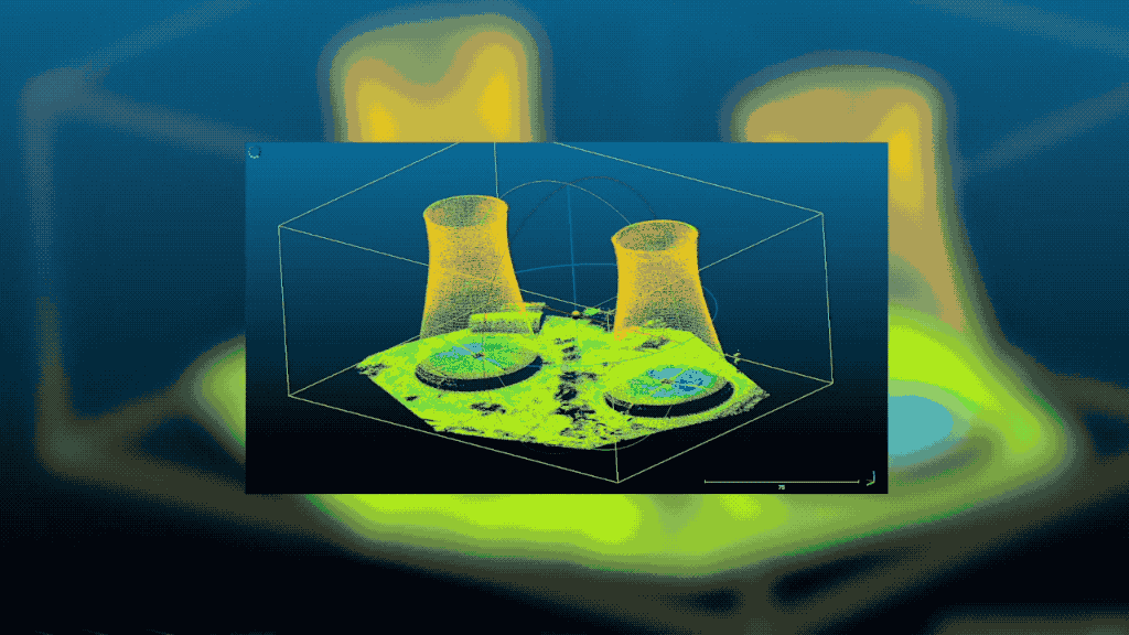
Case study: Cooling tower inspection
In advance of a reactor cooling tower demolition in France, the demolition firm needed to create accurate 3D models so that the process could be carried out precisely and accurately. Traditional inspection methods would be unsafe due to the presence of asbestos in paint on the towers. Furthermore, the job's timeline was tight, meaning the surveying would have to be carried out in the evenings.
Faced with these challenging conditions, the team used both photogrammetry and LiDAR drones to create 3D models of the towers. While much of the daytime work was carried out with photogrammetry, LiDAR was brought in for evening and dusk work, outputting 3D point clouds that quickly became detailed 3D models.
Read the full study to learn more about how UAV LiDAR functions on the job site.
LiDAR drones in action: Top use cases
Adding LiDAR UAVs is a great way for companies of all industries to map and survey more effectively. It’s impressive just how many unique deployment scenarios support drone LiDAR technology. Some of these cases can also incorporate photogrammetry, while others are wholly new and driven by the advent of affordable LiDAR drones.
Land surveying for small plots
Whenever there is a need to carry out an accurate aerial survey of a plot of land, a LiDAR drone can be the ideal tool. While a large plot of land may be more suited to a fly-over with a plane or a manned helicopter, drone technology is ideal for small plots.
 Easily construct accurate terrain maps to make informed landscaping decisions. Image by LiDARUSA
Using a drone as a surveying tool is more affordable than commissioning, staffing and fueling a standard aircraft. Furthermore, drones use a small UAV. which doesn't require pilots to fly over the site, making it a safer option. A few operators stationed on the ground can quickly and methodically map out the area and move on.
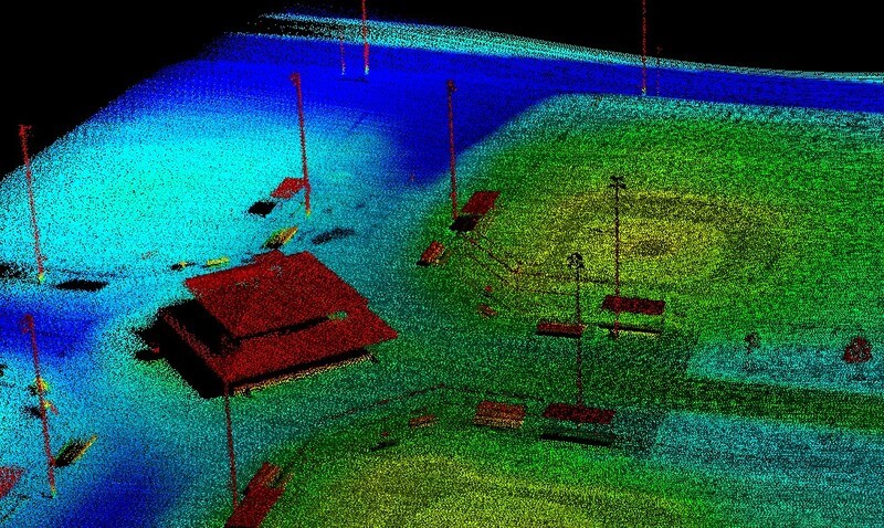
Topographic and bathymetric surveying
In addition to smaller surveys, LiDAR drones can use sensors to take in large topographical areas, taking over work that would traditionally be carried out from planes or helicopters. In the case of a land-based survey, the drone uses a near-infrared laser.
By flying over the water and using a water-penetrating green light, LiDAR drones can also collect readings about the depth of the sea floor or riverbed in a given area. When creating maps that incorporate bathymetric data, LiDAR drones can cover both the land and the sea.
Digital terrain modeling in advance of work
When companies are in the process of preparing for major dirt-moving work, it's important to have a map of the site in 3D. This is where an accurate digital terrain model (DTM) — created via a LiDAR 3D point cloud — can be pivotal.
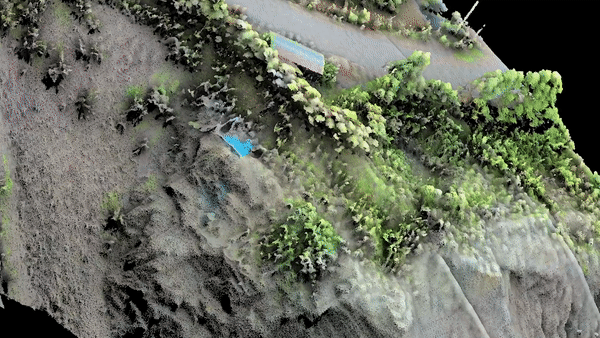 True-color point cloud captured by the Zenmuse L1
Dirt-moving is generally paid for by the yard of earth excavated, which means that for budgetary planning purposes, businesses need to know exactly what they are dealing with in a given area, using 3D imagery. LiDAR can penetrate vegetation and other features to give accurate readings about the topography of a given site.
Accident scene mapping and reconstruction
Drones of all kinds are becoming more popular in public safety — for instance, thermal drones can search for missing persons, even at night. In the case of LiDAR drones, the technology is ideally suited to complex accident scene reconstruction. Crews can carry out this work at any time of day, because LiDAR does not require light to work.
 Collision reconstruction in low-light conditions with LiDAR
After the highly accurate 3D model is captured, crews can clear the wreck scene. This timeliness is especially important when an accident site is obstructing traffic. The data from the LiDAR drone can then serve as evidence in any court cases stemming from the crash. Please note that photogrammetry is also an excellent option for crash scene reconstruction and emergency mapping, which you can learn more about in our Emergency Mapping Guidebook below.

Forestry
Measuring the inventory of a forest used for syrup, pape, or lumber production can be difficult or time-consuming because of the large areas involved. Companies that don't use LiDAR drones may have to rely on estimates based on workers' guesses.
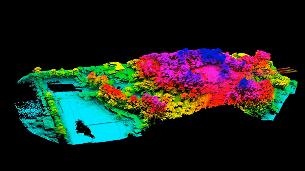 LiDAR can measure canopy heights and tree density
A LiDAR drone can not only give accurate readings of metrics such as canopy height and tree density, the sensors involved are precise enough to give readings about individual trees. LiDAR drones can even function in low light when visibility is limited.
Precision agriculture
Basing agricultural practices on precise data has become more popular in recent years, with photography drones helping with everything from crop planning to herd tracking. LiDAR drones can add a new level of accuracy to projections, allowing farmers to respond to conditions in their fields.
One major use of LiDAR drones in agriculture is providing 3D terrain data, which allows operators to construct levees in their rice fields. Another use is to measure the progress of crops, letting farmers use fertilizers in a more targeted fashion.
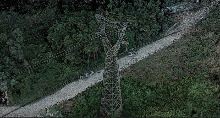
Power line inspection
While utility operators may have struggled to measure small infrastructure components (including power lines) before the advent of affordable UAV LiDAR systems, they can now carry out aerial inspections. Scanning power lines from the air allows surveyors to measure risk factors, such as the encroachment of vegetation.
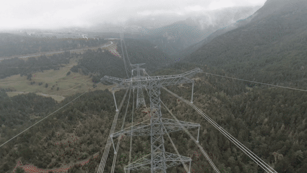
Whether taking readings about the current status of power grid infrastructure or planning to build new power lines, utility providers can rely on 3D models from LiDAR drones. The fact that the vehicles fly means they can cross rough terrain more easily and safely.
Mining
Mining companies can measure ore extraction space with mines. By calculating surface data and comparing current to past readings, miners can determine their operations' progress. Drones provide a more economical option compared to airplane surveying , and are safer and more efficient than ground-based scanning.
Sending drones into mines is another valuable way to collect data while foregrounding safety. SLAM LiDAR can serve as a collision detection tool while also allowing the drone to map inside a mine. After a planned detonation, a drone can enter a shaft first, making sure the structure is sound enough for humans to enter.
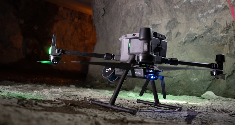 Matrice 300 RTK with an Emesent Hovermap
Archaeology
LiDAR drones are good at mapping the exact contours of structures — and these buildings don't have to be new. By using UAVs on an archaeological site, researchers can get a clear picture of the size and relative location of all relevant terrain features as well as any human-created remnants.
Mapping an archaeological site with a LiDAR UAV is quick and efficient compared to ground-based scanning and mapping methods. Since the drones can cover large areas, archaeologists can rediscover entire "lost" areas in a short time, even if those sites comprise entire ancient cities.
Stockpile volume measurements
Construction firms are going beyond surveying and using the systems for other functions such as inventory measurement. Repeatedly scanning a stockpile of materials allows a business to determine the rate of usage, allowing leaders to reorder at the right moment.
Understanding every aspect of a job site enables more efficient operations overall. Observing how much a stockpile changes in volume over time is possible with precise sensors, such as LiDAR, and mounting them on drones is an efficient way to put these solutions in action.
Top LiDAR drone options
With LiDAR drones becoming more widely available, technology buyers can start comparing hardware options to find the perfect UAV and sensor loadout for their purposes. The Zenmuse L1, a LiDAR sensor model available form DJI, is a valuable option for businesses due to its wide-ranging feature set, including:
- An integrated inertial measurement unit, capable of delivering survey-grade accuracy of 5cm and absolute accuracy of 10cm, all from an altitude of 50 meters.
- A 3-axis stabilized gimbal, which enables fully automatic mount control through integration with the DJI flight management system.
- A 1-inch 20MP CMOS sensor, which records photo and video data. This enables users to apply color data to LiDAR point clouds, alongside other functionality.
- Support for three returns per laser shot, delivering a greater degree of accuracy when penetrating dense foliage and measuring the topography of the land underneath.
- A non-repetitive scan mode which delivers a higher degree of resolution for data compared to a regular scan line when a drone records a single area for an extended time.
- IP54 certification, attesting that the L1 can function in adverse weather such as fog, smoke, and snow.
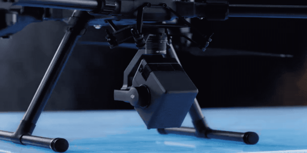 Zenmuse L1 on a 3-axis stabilized gimbal
The L1 is designed to be deployed with the versatile and powerful Matrice 300 RTK. which is mounted with multiple gimbals to allow operators to use several sensor payloads at the same time. The point cloud data from the drone can then be assembled into 3D models with DJI Terra software. With this LiDAR UAV in action, companies from construction to public safety to agriculture, mining and beyond can transform their day-to-day workflows.
L1 owners can optimize their operations with L1 by referring to the L1 Operation Guidebook V1.1. This resource covers in depth everything you need to know about your L1, from specs and settings, to which parameters to use for which scenarios, to payload calibration, mission planning, and data processing with DJI Terra.
To help you decide if a LiDAR drone is right for your company's circumstance, contact a DJI representative or read more about how drones have made a difference for our customers.


-2.png?width=300&name=HS%20-%20Featured%20Images%20(2)-2.png)

