
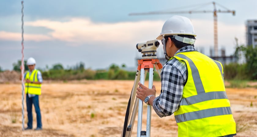
Because accuracy and reliability are essential for surveying professionals, it’s understandable that many have hesitated to adopt drone technology. Traditional methods work, and as the old saying goes, if it ain’t broke, don’t fix it.
But there are misconceptions driving this skepticism. Many surveying projects can be successfully completed with the accuracy drones provide. And while there is a precision tradeoff in some instances, there are tremendous cost, time, and safety savings to be made when integrating drones into traditional workflows.
Drones have become transformative tools in a range of industries. Surveying is no different, but traditional methods will always have a place. Indeed, in some cases, they represent the only possible solution.
Why are traditional surveyors switching to drones?
Time, cost savings, and safety improvements are the headline benefits that drones bring to a host of sectors. All three are already impacting the work of surveyors.
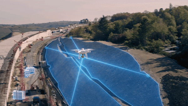
Take the example of Altametris, a data collection and analytics subsidiary of French rail giant SNCF. When comparing different methods during the survey of a stretch of railroad, the team discovered that the DJI Matrice 300 RTK and Zenmuse P1 payload combined to reduce operation preparation time by two hours. This is because the built-in RTK module and Zenmuse P1's full-frame sensor delivered enough metadata to effectively reduce the number of Ground Control Points (GCPs) required to zero.
For Altametris, previous surveys accurate to 3cm would require 40 GCPs per square kilometer. A time-consuming tacheometer would also need to be deployed.
On top of taking up valuable hours, these methods involve physically handling equipment on and close to the railway. It’s both a dangerous and a complex place to work. The introduction of drones into the equation meant fewer hours on-site, more automated processes, and less risk to surveyors - all without sacrificing the accuracy required. In fact, the Zenmuse P1 excelled despite low light conditions.
By reducing the number of GCPs required for surveying missions, sophisticated drones can save surveyors a huge amount of time. But it’s arguably in inaccessible or dangerous areas where the technology comes into its own. Train tracks are just one example of a working environment that’s far better suited to autonomous machines.
The final point to note is the depth of data that’s possible with drones. Despite needing a fraction of the manpower, a point cloud with millions of data points and, in many cases, greater detail, can be achieved in a reasonable turnaround time. To get the same output from classical methods would require significantly more time, instruments, and cost.
Which types of surveying projects are ideal for drones and traditional surveying tools?
Despite the benefits drones offer compared to traditional surveying methods, there are situations in which the old ways remain an important part of the equation.
The first thing to consider is the degree and type of accuracy that your project requires.
It’s here where the difference between relative accuracy and absolute accuracy is important. For many applications, relative accuracy - the accuracy of where objects are in relation to one another - is all that matters. The result of these projects can be reconstructed models such as 3D point clouds or orthomosaic maps. When the objects’ true positions on Earth are an important factor in the equation, a surveying process that provides absolute accuracy is necessary.
Taking a relative approach is a simple way to accurately assess volumes, distances, and height variations. But if that data is going to be combined with further informational layers, or if you are hoping to develop professional photogrammetric survey documentation, those measurements will need to be geographically oriented using Ground Control Points and/or supported by UAV Real-Time Kinematic (RTK) technology. RTK is a GPS correction solution built into drones that works with a ground station to accurately geotag images with GPS information as they are captured.
As a general rule, projects that require accuracy to within 2cm will need to be augmented by traditional methods. Drones consistently achieve 5cm accuracy, and depending on the payloads and flight parameters, up to ~1cm accuracy. If your project demands 2, 1, or even millimeter-level accuracy, traditional tools remain the best option.
Surveying projects ideal for traditional surveying tools
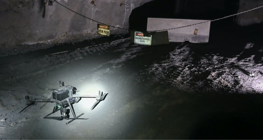
Surveying projects that are indoors or underground
Due to limited GPS signal and low-light conditions, projects underground and inside are not generally well-suited to drones. Instead, exploring the geometry of caves and internal structures is best done with tacheometric surveying methods, or, for higher speed and higher-resolution results, terrestrial laser scanning (TLS) technologies.
Having said that, some companies are working on solutions that combine drones, simultaneous location and mapping (SLAM) navigation capabilities, and LiDAR sensors to map complex underground areas. It won’t be long before drones play an important role below ground, particularly as surveyors seek to merge data from different sources with more sophisticated workflows.
Surveying projects that involve obstructing objects
Aerial surveys can also be complicated by the presence of buildings or dense canopy foliage. These issues are compounded when obstructions mask changes in elevation. LiDAR can work through light foliage, but dense trees will block the ground and reduce the accuracy of the end result.
Projects that have no strict deadline
Time is money. And one of the greatest benefits of surveying with drones is the reduction in the time it takes to complete the job. However, not all projects need to be completed yesterday, and not all surveys require a balance to be found between accuracy and mission time.
Drones cover ground faster than people can and the right hardware can drastically reduce the number of GCPs needed. But if you’re happy to spend the extra time necessary for increased accuracy, you could continue with traditional methods.
Surveying projects where drones shine
Inaccessible areas
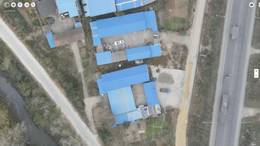
Some environments and infrastructure are literally beyond the reach of traditional surveying techniques. But when data needs to be gathered - particularly at scale - drones are the ideal solution. Cell phone towers, solar farms, and treetop canopies are just a few examples of areas that can be mapped easily using drones.
Dangerous terrain
Just because an area is within reach of ground-based surveying techniques, it doesn’t follow that it’s wise or safe to do so. Hazardous locations, including rooftops, ledges, roadways, unstable soil, steep embankments, and, as mentioned above, railway lines - all are dangerous places to work. Innovative drone solutions can carry out surveying tasks while without risking teams on the ground.
When data depth matters
A significant benefit to aerial surveying is the depth and variety of potential outputs available. If you’re conducting an agricultural survey, multispectral sensors and high-definition cameras can gather the data you need to assess crop health and understand the situation in granular detail. If you’re carrying out a topological survey ahead of a construction project, LiDAR and photogrammetry enable 3D point clouds, orthomosaic maps, and high-density digital terrain models for a comprehensive overview. If you’re estimating stockpiles and looking for accurate volume measurements that aren’t hindered by human error, a few clicks of a drone’s camera can gather the information you need without putting staff in harm’s way.
Why the Phantom 4 RTK is the perfect surveying starter drone
Choosing the right hardware for surveying missions is critical for a number of reasons.
For starters, a key parameter for any survey is your spatial resolution or Ground Sampling Distance (GSD). The detail captured in every pixel is a factor of your drone’s sensor resolution, focal length, and the altitude at which you fly. The first two elements are clearly hardware dependent. But you could also argue that your chosen surveying altitude is a result of other hardware factors, such as flight time and speed.
The DJI Phantom 4 RTK is a complete out-of-the-box solution that’s highly capable, easy to use, and affordable. It houses a one-inch, 20-megapixel CMOS sensor. Its mechanical shutter speeds up image acquisition with minimal distortion compared to consumer models. A wide-angle lens with a 24mm focal length delivers clear, consistent images.
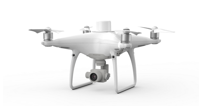 DJI Phantom 4 RTK
A centimeter-level navigation and positioning system supports both RTK and PPK surveying methods. The RTK module is backed by GPS L1 L2, GLONASS L1 L2, Galileo E1 E5a, and BeiDou B1 B2. It can effectively reduce the required amount of GCPs to 0. Although a handful of GCPs per square kilometer is still recommended for optimum results, P4 RTK users can save at least 75% in GCP set-up time. The P4RTK relies on TimeSync technology to coordinate its camera and RTK receiver, tagging each image with accurate geospatial information. Corrections are also received from the base station on the ground, resulting in a high degree of accuracy.
The P4 RTK also has hot-swappable batteries, a ~30-minute flight time, and a top speed of over 30mph, allowing surveyors to cover more ground in less time. All dovetail with the DJI GS RTK app and a remote controller that has a monitor built-in and multiple planning modes, including Photogrammetry (2D and 3D), Waypoint Flight, Terrain Awareness, and Block Segmentation.
This is a game-changing upgrade for surveyors currently using consumer drones for mapping missions.
Phantom 4 RTK Data Outputs
Surveying with a Phantom 4 RTK unlocks a world of data possibilities. The exact deliverables depend on your choice of software, but potential outputs include:
Orthomosaic Maps
Every orthophoto the P4 RTK captures during a surveying flight contains geospatial information and is processed and corrected to account for the perspective from which it was taken, potential lens distortion, the tilt of the camera, and topographical variation.
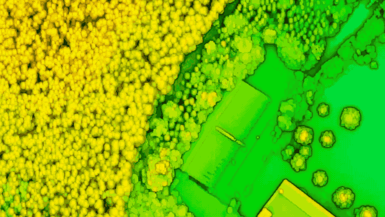
One of the most common survey outputs is a high-definition orthomoasic map. By stitching together the images captured by your drone, you can provide a bird’s eye view of an area as it is now, aiding planning, decision-making, and project progress tracking.
 Orthomosaic
3D Surface, Terrain, and Elevation Models
Because P4 RTK drone images include datapoints across latitude, longitude, and altitude, every pixel carries data across three dimensions. This means that among the most compelling outputs from a drone survey is a 3D model.
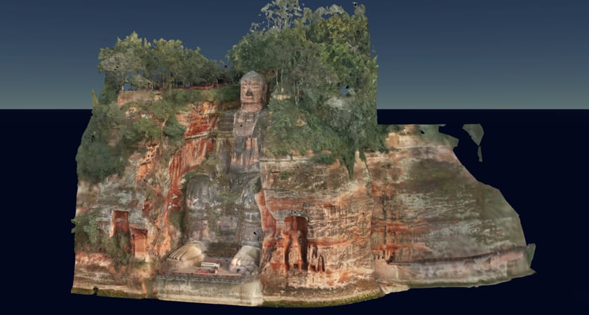 3D model of the Leshan Buddha in Sichuan, China. See the model here.
These realistic and immersive models combine high-definition visuals with accurate geographical data points. The result is a navigable tool that can be used for project planning, taking accurate measurements, and progress analysis.
The prime example is a Digital Surface Model, which provides a textural feel of a site and an instantly recognizable exploratory tool. Digital Terrain Models are built with the same data but are stripped of manmade structures and objects. As the same suggests, the focus is on the terrain. Lastly, Digital Elevation Models go one step further, representing the bare-Earth surface by removing both natural and manmade features. Digital Elevation Models are used in the contouring of topographic maps.
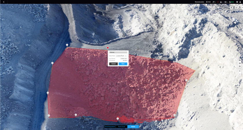
Volumetric Surveys
The P4 RTK can gather the data required for volumetric models, which can be used to measure stockpiles in the mining and construction industries. You can read Heliguy and Terra Drone Europe’s case study and methodology here. The verdict? The P4 RTK "is a high accuracy survey tool."
Drones in action: Using the P4 RTK to map transport infrastructure
Rhein-Neckar-Verkehr GmbH (RNV) operates public transport in the Rhein-Neckar region of Germany. The company’s responsibilities include a 301km tram line and 827 km bus line, that’s used by 370,000 passengers every day. In an experiment conducted with surveying specialists Vermessungbüro Wolfert GmbH (Heidelberg) and with support and training from DJI Enterprise Dealer Epotronic. RNV compared the performance of the P4 RTK against traditional methods (Total stations) when surveying a stretch of train tracks.
The comparison entailed flying over a section of the track, gathering images, and processing them before taking measurements from the 3D model generated. The results were then assessed alongside RNV’s standard measurement templates.
Viewing the CAD outputs from the Total Station survey side by side with the CAD and point cloud outputs from the P4RTK, it’s clear how much more data was gathered by the DJI drone. Aerial data also allows for orthophotos that can be oriented and manipulated to simplify project planning.
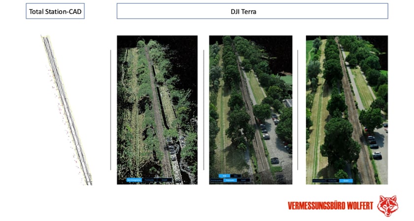
This amount of detail is particularly useful when surveying the foundations of a planned route. At a granular level, Vermessungsbüro Wolfert compared the accuracy of the two measurement methods and found that the P4RTK was accurate to within 1.5cm of the Total Station results.
Arguably the greatest benefits to using drones for the task were procedural. During a traditional surveying project, teams are forced to work on and around tracks while they are shut down for the duration. The first thing RNV noted is that ‘contactless’ surveys from above reduced safety risks to teams on the ground and allowed transport operations for the light rail service to continue. As well as fewer delays to the timetable, measurements that are usually limited because of time pressures - such as track height - could be gathered with ease.
There were also advantages to the depth of the outputs generated from the P4 RTK. With comparable accuracy, the orientation of 3D models from an aerial perspective led to intuitive data that is arguably more accessible for those in search of insights. However, the Vermessungsbüro Wolfert team did point out that certain data points can’t be captured from above, such as areas under dense foliage. For this reason, surveys that combine aerial photogrammetry with classic surveying methods may have a role to play.
Ready to unleash the Phantom 4 RTK?
A single flight with a Phantom 4 RTK can provide the data you need to generate orthomosaic maps and precise 3D models. Want to find out more? Dive into our report on the P4 RTK’s accuracy, or order yours via the DJI Enterprise store.


-3.png?width=300&name=Insight%20blog%20featured%20image%201140X660%20(2)-3.png)