Raptor Maps, a leading provider of solar software, is collaborating with DJI Enterprise to provide input and testing for the latest update to DJI’s Pilot 2 flight planning software (update notes). Available for the Mavic 3T (M3T) drone, the update further improves the M3T's ability to efficiently and accurately capture data for solar farm inspections, reduces user error, and ultimately allows for a “hands-off” aerial thermography inspection from start to finish that complies with Raptor Maps’ data capture standards.
Aerial thermography via drones has become the go-to inspection solution for solar inspections, providing safe, efficient, and higher-quality methods of data capture. Leveraging DJI’s Thermal SDK to ingest images from DJI’s drones, Raptor Maps then processes and analyzes these images to provide accurate and actionable insights into equipment anomalies that impact power production and drive revenue loss for asset owners, all mapped and geo-referenced to a digital twin of the solar farm.
As a leading provider of solar asset management analytics, Raptor Maps identified the opportunity for flight planning improvements with feedback directly from pilots in the field.
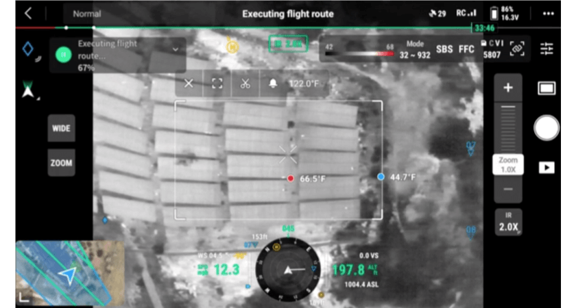
 With the software update, pilots can view the thermal and visual feed during flight.
Updates to Pilot 2 software boost M3T drone efficiency
With DJI Pilot 2’s updates, pilots using the M3T drone no longer need to adjust the aircraft orientation after each waypoint, removing the guesswork of whether or not the flight boundary set will be big enough to cover all of the rows of a flight boundary. Moreover, the update adds the ability to automatically adjust a flight path based on a given camera angle, reducing the guesswork involved with flying a set inspection area.
Pilots can view the thermal and visual feed during flight and monitor live temperature readings. Thermal camera values such as emissivity can also be adjusted before or during flight.
 A screenshot of DJI Pilot 2 App
Tests by Raptor Maps’ internal experts have shown both enhanced speed and quality of data capture, as well as a reduction in the overall pilot time investment required to accurately and safely inspect a solar farm. These improvements can be attributed to the new ease of mission planning and the M3T’s 0.7s shutter speed for capturing both visual and thermal images allowing faster flight speeds.
This flight mode planning was only previously possible with the Matrice 210 + Zenmuse XT/XT2 utilizing DJI GS Pro. When conducting data capture for a Raptor Comprehensive-level Inspection of a 10MW solar farm, you can see the time difference of 1 hour and 40 minutes below between these two systems, not to mention the additional time saved by avoiding additional battery swaps with the M3T’s 45 minutes of flight time (17 minutes more than the Matrice 210 + XT2). When taking into account battery swaps and flight time to return to home, in this example, the M3T performs the data collection about 4 times faster.
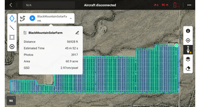 A screenshot from DJI Pilot 2 for M3T
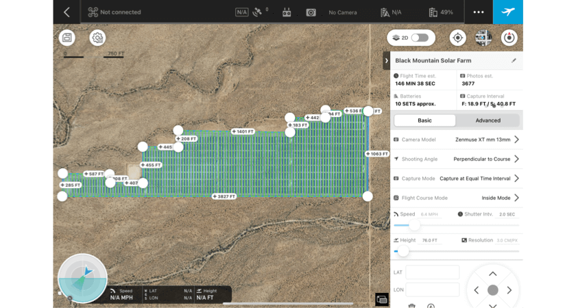 A screenshot from DJI GSPro for M210 + XT2
“We’re very excited about this new update from DJI as it will make a huge impact on making solar inspections easier for our pilots and more consistent for our processing needs,” said Chris Wilson, Raptor Maps Data Manager and one of Maps’ in-house drone experts. “This enables a ‘hands-off’ aerial thermography inspection experience for the drone pilot, adding much-needed automation and user experience improvements.”
You can enable the custom aircraft heading and gimbal pitch by going into Advanced Settings when planning a mapping mission for the M3T in the Pilot 2 application.
DJI also plans to add the ability for enabling terrain following based on a digital surface model with this flight mode in a future update. This same mission planning capability is planned for the Matrice 30 series, while the M300 series gimbal can currently be rotated for data capture needs.
If you are interested in learning more about Raptor Maps’ solutions, you can contact them here.
About Raptor Maps
Raptor Maps is building the operating system for the solar industry, enabling the industry to scale and meet global climate goals. With intelligence for the entire solar industry, our solar lifecycle management platform (Raptor Solar) provides the tools and the system of record that asset owners, managers, O&M, developers, and EPCs need to build, maintain, and expand their solar plants. At the core of the platform are continuously evolving, geo-referenced digital twins of your solar assets, which integrate with the data sources you need to derive actionable insights. Raptor Solar bridges the gap between insight and action, improves asset health and power production, reduces risk, and ultimately increases the rate of return of solar assets. To learn more about Raptor Maps or to schedule a demo, contact us at raptormaps.com/contact