
Did you know, if bees were to become extinct, humans would be able to grow only 28 crops, because all other varieties of crops depend on bees for pollination? Did you know that some species serve as buffers between humans and dangerous pathogens, the removal of which has led to the rise in incidences of diseases such as the West Nile virus and Lyme disease?
All species are connected in the web of life, a European Commission study has determined, saying that “even the most resilient species will inevitably fall victim to the synergies among extinction drivers as extreme stresses drive ecosystems to collapse.”
The biodiversity loss kindled by the climate crisis has brought so many species near extinction that scientists are having a tough time deciding which ones to save and which ones to leave behind. But decide we must, because climate change increases the risk of an ‘extinction domino effect’.
To avoid this worst-case scenario of ‘co-extinction’ and to ensure that we don’t become the generation that failed the planet, our efforts to conserve biodiversity and ecosystems must be underpinned by the best tools that technology can offer. One of these tools is drones.
Conservation drones have become prevalent in many fields of wildlife monitoring and management. With advances in technology making drones more portable, affordable, efficient, and weather-resistant, these flying machines have become a popular choice for conservation purposes. Let’s look at some of the most innovative uses of drones in wildlife conservation work today…
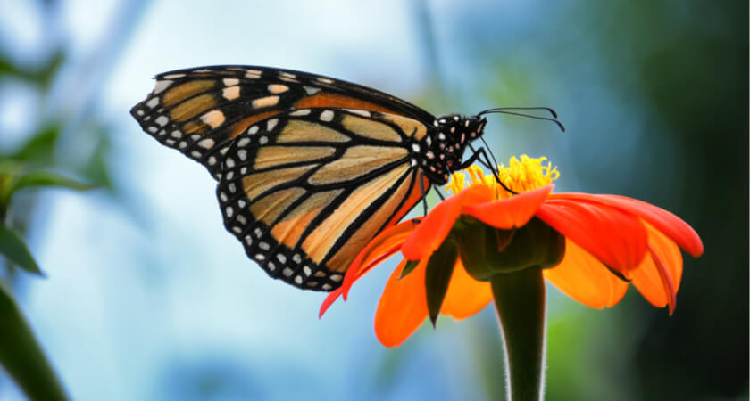
Multispectral and LiDAR help protect Monarch butterfly habitats
The Monarch butterfly’s annual migration is one of the world’s most fascinating natural phenomena, and is one of the longest and largest in the insect world, spanning more than 4,000 km. However, this migration is at risk of extinction due to environmental changes, habitat destruction, and deforestation that jeopardize the monarch’s breeding grounds.
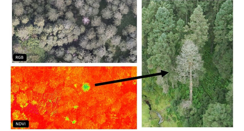
In particular, the Oyamel fir, the Monarch’s preferred tree for their winter hibernation, is under threat from a mysterious phenomenon that causes the tree to turn white, lose its foliage, and die. If these trees continue to disappear, and actions aren’t taken to protect this vital habitat, the monarch butterfly migration phenomenon may be lost forever.
For this reason, the Neovolvanic Axis Conservation Fund (FOCEN) an organization dedicated to preserve the habitats and forests where the monarchs hibernate, is searching for every means possible to protect and support this phenomenon. In a partnership with Cielito Drone and DJI Enterprise, they have turned to LiDAR and multispectral drones to collect vital forestry data in an effort to preserve these critical habitats.
Working with drones is far more efficient and enables them to collect year-on-year data. A survey that used to take 6 days on foot can now be completed in a single day with a drone.
Read more about multispectral drones and monarch butterflies.
Drones in oceanography: Snot(bot) and whale tagging
Whales play a significant role in the health and stabilization of the world’s oceans – in life and death. As they live, these wondrous beings act as marine ecosystem engineers, regulating a wide variety of oceanic organisms. And when they die, their massive carcasses sink to the seafloor and provide essential nutrients to deep-sea life.
Add to the mix the fact that these aquatic giants also contribute to the global cycling of environmental resources like carbon, nitrogen, and iron, and it’s easy to understand why environmental researchers around the world are concerned about the conservation and management of this endangered species.
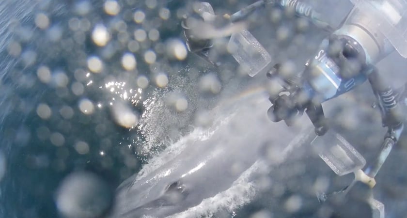
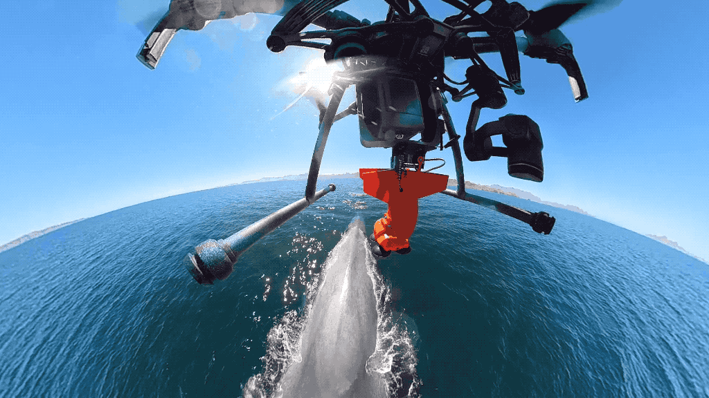
Traditionally, to learn more about the biology and behavior of these majestic creatures, researchers have relied on lethal scientific whaling. But today, to gather biological data from whales, all you need is a drone, Velcro, and a few Petri dishes.
Ocean Alliance, a nonprofit organization, has been using a modified DJI Inspire 2 drone for drone whale research. The ‘SnotBot’ collects blow samples from whales as they come up to the surface and exhale. These sticky, clear-colored blow samples contain whale DNA, microbiomes, tissue particles, stress and pregnancy hormones, and other viruses, all of which are a telling indicator of the great mammal’s health.
In addition to being a non-lethal, non-invasive marine research method, conservation drones like SnotBot are also democratizing access to marine research. Because it takes serious financial backing to charter expensive marine vessels and equipment, whale research has long been restricted to a privileged few. But now, drones in oceanography are making data collection affordable, replicable, and scalable for researchers everywhere.
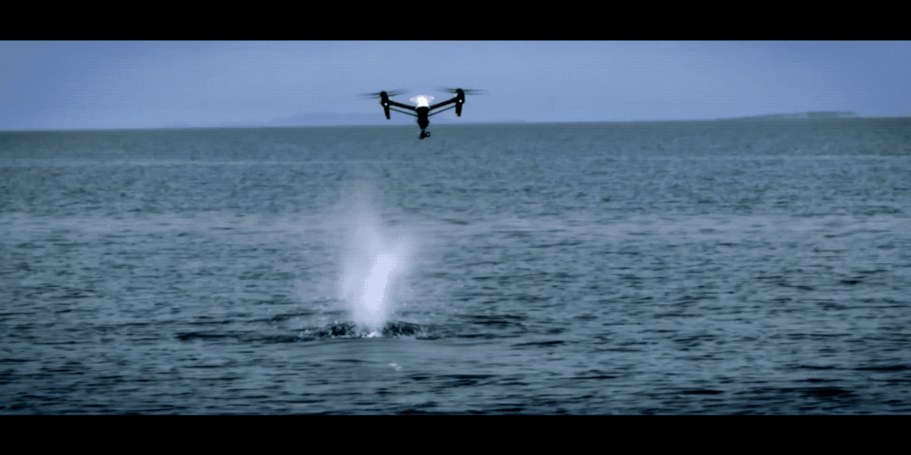
And it's not only about collecting snot - Ocean Alliance has pioneered a novel way of attaching waterproof data trackers to the backs of whales using drones. For decades, marine scientists have used data tags to track whales underwater. One common type of tag is fixed using suction cups and can carry a range of sensors - including a hydrophone, an accelerometer, and a camera. The data these tags collect provides researchers with insights into a whale’s hunting patterns, kinetics, acoustics, and even social interactions.
Just as with the collection of biological samples, tagging has traditionally been a dangerous and costly process. A team of experienced scientists across multiple vessels will spend countless hours chasing whales. It’s inefficient at best.
With the help of drones, things can be different. On an expedition in the Gulf of California in February 2022, Ocean Alliance became the first team in the world to successfully use flying robots to revolutionize the tagging process. The innovation could have huge implications for whale science and marine conservation more broadly.
Learn more about SnotBot and Whale Tagging directly from Dr. Iain Kerr, the CEO of Ocean Alliance.
Protecting Tierra del Fuego's unique biodiversity with World Conservation Society Chile
Tierra del Fuego, located at the southern end of Patagonia, is a unique and biodiverse region. It is home to a variety of plant and animal species that have adapted to the harsh sub-Antarctic climate.
Karukinka Park, a private conservation area of 300,000 hectares located in Tierra del Fuego, is critical from an environmental standpoint - this region’s sub-Antarctic forests and peatlands are essential ecosystems capable of absorbing large amounts of atmospheric carbon, making it an important ally in the fight against global warming.
Caretakers of these lands, the World Conservation Society Chile (WCSC) has been at the forefront of conservation efforts in these lands for more than 17 years, working to protect key species and ecosystems in the country.
The use of drones has been instrumental in scaling and elevating of WCSC’s conservation efforts in the region. The M30T has enabled the WCSC team to directly monitor species such as guanacos, foxes, elephant seals, and black-browed albatrosses.
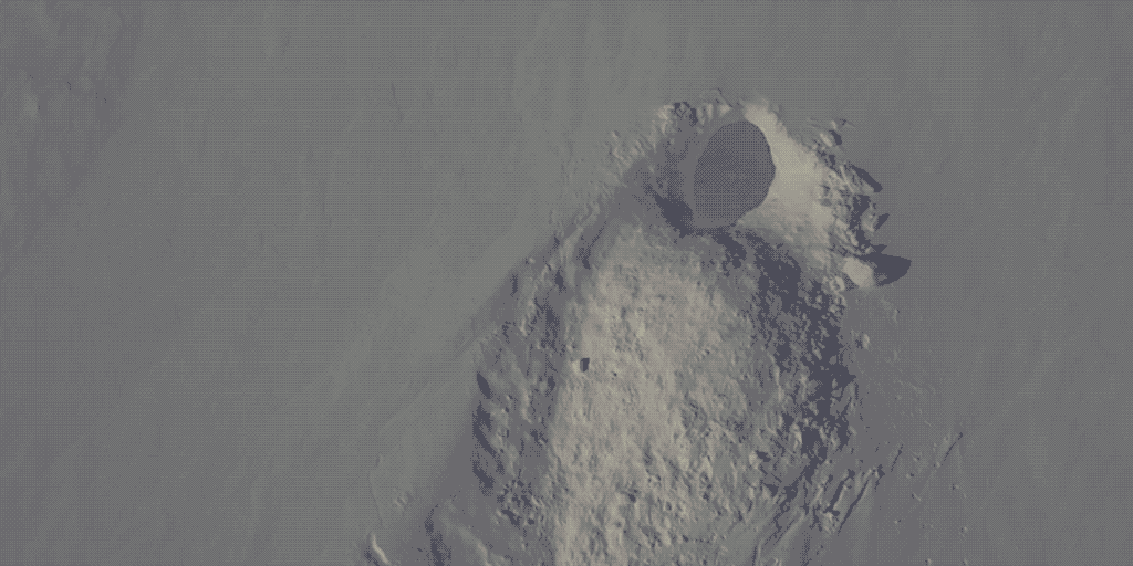
Protecting fawn from industrial mowers
Between late April and early Summer, a female deer gives birth to one or two fawns who she protects from predators by nesting in the tall grasses of meadows and even domestic lawns. Unfortunately, these breeding patterns clash with farmers’ need to mow the meadows for hay. It is almost impossible for a mower operator to recognize the tiny figure of a baby deer, tucked away in the tall grass. To make matters worse, when confronted by danger a fawn’s natural instinct is to remain completely still making it that much harder for the mower operator to avoid killing or seriously maiming them.
And there are some unsettling numbers to back this up – in Germany alone, it is estimated that around 90,000 fawns every year are killed by mowing machinery with similar numbers seen across Europe, from Norway to the Netherlands.
Until now, the sole solution to this problem has been for teams of farmers and dogs to manually check every field to check for nests - a laborious not to mention hit-and-miss method because of the difficulty of spotting the deer.
A clever solution to the fawn problem is to fly a thermal drone, such as a Matrice 30T or a Mavic 3T, over the fields before they are set to be mowed. The drone can easily and efficiently pick up on the heat signatures of the fawns, and conservationists can move them to safety before the mowers drive through.
Drones in conservation photography: counting the lion’s whiskers
As the predator-in-chief of their habitat – be it grasslands, scrubs, or open woodland – lions have the all-important role of regulating the food chain and controlling the herbivore population. But with only around 20,000 African lions left in the wild, the king of the beasts has been officially declared as a ‘vulnerable species by the International Union for the Conservation of Nature (IUCN). And given their current rate of poaching and habitat loss, researchers fear that these amazing cats could be completely extinct by 2050.
So, you can imagine how essential it is for wildlife biologists to get accurate counts of African lion populations. The task is equally challenging though.
Historically, the survey methods used to count lions have been very imprecise. Population estimates are based on track counts, audio lure surveys, or expert solicitation of the lions – techniques that are simply not reliable enough to understand how prides are faring over time.
A more promising survey approach, that has been trialed recently, involves taking high-resolution photographs of the lions and capturing their unique whisker print. Yes, just like no two humans have the same set of ridges and lines on their fingers, the number and arrangement of whiskers on a lion’s face are also distinct. And drones have made capturing and recording these unique whisker spot patterns quite easy.
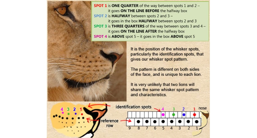
Source: Living With Lions
How exactly are drones effective in conservation photography? A small drone, such as the DJI Mavic 2 Zoom, can fly within a few meters of a lion without disturbing them and capture a 48-megapixel super resolution photo with 2x optical zoom. What about the noise? Turns out, once a lion gets habituated to a drone flying in a distance, it thinks that the machine is nothing but a small, noisy bird!
Drones protect wildlife: koala search and rescue
WWF-Australia describes the Australian bushfires of 2019-20 as ‘one of the worst wildlife disasters in modern history’ and not without reason. The unprecedented fire season consumed over 12.6 million hectares of land across the continent, killing or displacing almost 3 billion animals. Of these, more than 61,000 were koalas, the iconic marsupials native to Australia.
Sadly, even before the bushfire crisis, the much-loved koala was considered vulnerable to extinction because of threats posed by hunting, land development, food degradation, droughts, and disease. So, when the fires raged, forest and wildfire officers quickly turned to drones to search for surviving koalas in both burnt and unburnt areas.
In the state of Victoria, the emergency crew flew DJI’s Mavic 2 Enterprise Series drones with high-resolution thermal cameras to detect the heat signatures of the koalas. Once bears were located, the ultra-zoom visual camera on the same drone helped first responders to determine if the animals needed medical attention. For those in need of assistance, cherry pickers were used to fetch them down.
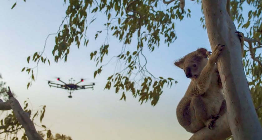
Research scientists in the neighboring state of New South Wales also concurred that wildlife mapping thermal drones were much cheaper and more efficient than using traditional surveying methods such as scat surveys or spotlighting with head torches. This, because, as instantly recognizable koalas may be, they camouflage really well and are notoriously difficult to detect.
Interestingly, thermal drones have emerged as a formidable tool in other areas of firefighting as well. From detecting invisible hotspots and preventing secondary fires to gathering wildfire data at night, no other emerging technology has improved firefighter and civilian safety like thermal imaging drones have.
Drones for wildlife surveys: studying procreating penguins
Penguins are remarkable creatures. The Penguin family consists of about 18 species of birds spread across the Southern Hemisphere, dividing their time between the land and the sea, playing an indispensable role in the food chain of both land and ocean ecosystems. So much so, research has proven that penguin health equals ocean health.
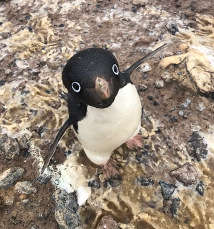
But climate change is a growing concern for the penguin population. This is why, every Antarctic summer (roughly October through February), scientists descend on the icy snow-covered desert of Antarctica to study the penguins and determine whether there might be a correlation between population fluctuations and the shrinking seasonal levels of frozen sea ice.
In the past, the standard practice was to manually tag individual penguins. Helicopters proved to be too noisy and intrusive, even if you dismissed their exorbitant costs. And the truly valuable data couldn’t be captured without flying below legally permissible altitudes. So, biologists had little choice but to get down to the penguin colonies themselves, tag a bunch of birds by hand, and go back every subsequent year to locate as many of them as possible.
That all changed in 2017 when DJI drones came into the picture. Human-piloted single-drone surveys began to capture colonies spread over 2 square kilometers, housing as many as 300,000 nesting pairs, in just 2 days. By 2020, that time had shrunk further to a mere 3 hours, thanks to a new flight path algorithm that enabled autonomous flying of multiple drones.
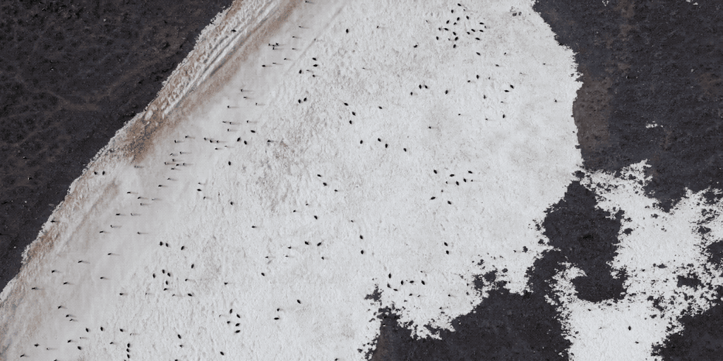
Now, researchers have trained machine learning algorithms to automatically detect and classify penguins in the massive, high-resolution drone data. And the same technique can be applied anywhere there’s a need to gather accurate aerial data quickly and efficiently, even in extreme winter weather conditions.
Wildlife monitoring drones: detecting denning polar bears
Polar bears are the poster child of climate change. Images of scared, starving polar bears clinging to dear life on a small chunk of sea ice have been used by environmentalists across the world to illustrate the impact of global warming on the Arctic. But the importance of polar bears does not end with their ability to invoke a strong emotional response toward the climate emergency. Polar bears are at the top of their food chain and are critical for the overall health of the marine environment.
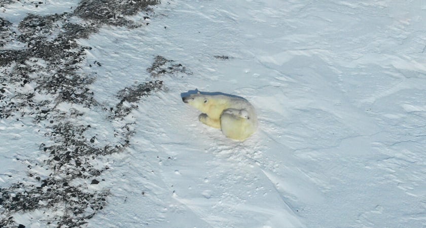
And with only 22,000-31,000 polar bears remaining on Earth, scientists are naturally interested in closely monitoring their population, especially during the denning season, to gauge the effect of the climate crisis on the species.
Wildlife monitoring aerial surveys have conventionally been carried out via expensive helicopter flights. But in an area where everything looks like a sea of white from the chopper’s open doors, spotting the one-meter-wide den hole has often proved difficult. To complicate matters further, pregnant bears tend to prefer the upper slopes of the Arctic mountains which transform into a blinding mirror when the high noon sun streams in.
And so, researchers are now using thermal imaging drones to locate the dens that are typically 10-15° C warmer than the ambient temperature. The DJI Mavic 2 Enterprise Series drones can safely withstand the cold and gusts of wind to fly at a distance that does not disturb the bears, as a team of researchers discovered recently. Having both a thermal camera and 30x zoom camera on a single, easy-to-fly drone not only made polar bear monitoring quick and safe, but it also greatly facilitated the search and study of both the dens and the animals.
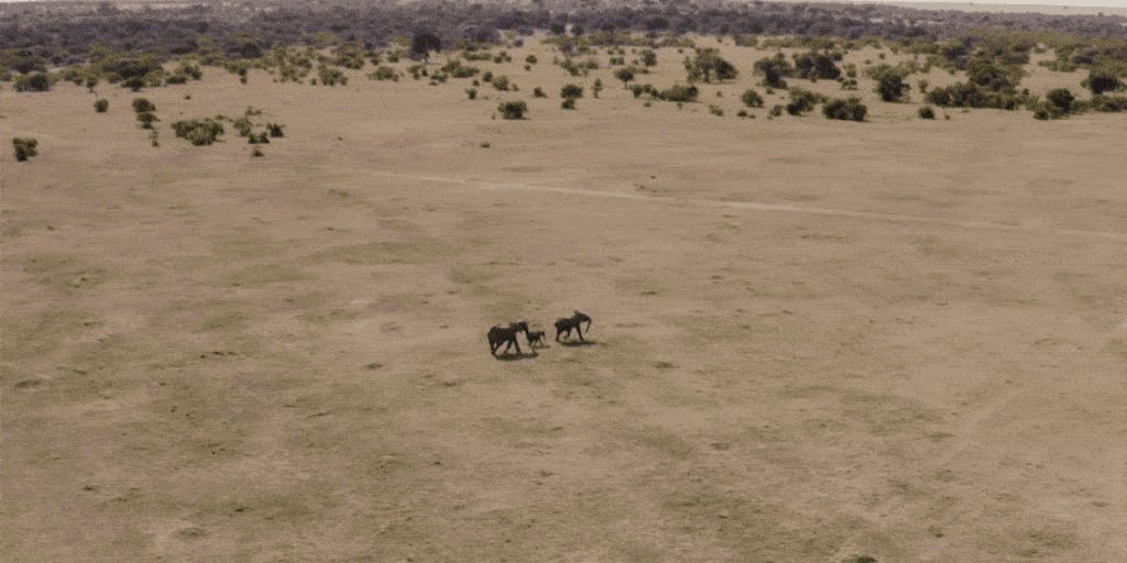
Anti-poaching drones: saving the elephant
Elephants are important ecosystem engineers and help maintain the biodiversity of forests and savannas. And yet, every year, 20,000-40,000 elephants are lost to poaching, despite an international ban on the ivory trade.
The situation is so bad that the African elephant, which was previously classified as ‘vulnerable’ by the IUCN, got promoted to the ‘endangered’ list last month when research revealed that the number of African forest elephants had fallen by more than 86 percent in the last three decades.
To combat this poaching epidemic, elephant protection organizations in Kenya have started leveraging anti-poaching drones, like the DJI Mavic 2 Enterprise Dual or the Mavic 2 Enterprise Zoom. With drone cameras capable of 30x zoom and thermal imaging, poachers can be located both during the day and at night. Anti-poaching drones relay live video to ground-based conservation teams, often safely miles away, who can even record the footage for later analysis. Any wildlife monitoring findings are then shared with forest rangers and police.
The results, so far, have been extremely encouraging. Kenya’s Mara Elephant Project, for example, started using anti-poaching drones in 2014. In 5 years, the organization was able to bring down the number of illegally killed elephants from 83 percent to 44 percent, arresting over 300 poachers in the process, and seizing more than 1,000 kg of ivory.
Drones and wildlife are a good mix: from a safe distance
Here, you have seen only a small sampling of conservation and anti-poaching projects where responsibly-used drone technology is at the forefront. Many more countries and organizations have adopted drones to gain an unprecedented look into wildlife at hard-to-reach places. From monitoring Sandhill Cranes in Colorado and counting waterbirds in Florida to surveying orangutan nests in Indonesia and seals in the Arctic waters, conservation drones are flying at a safe distance to both protect endangered wildlife and empower environmentalists to work more safely, accurately and economically.
To know more about how drones are helping to save the environment, read How Drones are Saving the Planet.
#DronesHelp
#DronesHelpPlanetEarth


-2.png?width=300&name=HS%20-%20Featured%20Images%20(2)-2.png)
