
Do you ever find yourself asking “How much inventory do I have on my site?” or “How much material do I have in this stockpile?”
These are common questions that those in the AEC, Mining, and even Agriculture space ask every day. The need of knowing exact inventories across the site is important, and the current frequency of calculating piles on a site is never enough. Safety and time concerns plague the ability to get quick and accurate measurements on the ground. But what if you could calculate stockpiles on your site with extreme accuracy and high frequency? By using DJI Enterprise drones and DJI Terra software, it’s never been easier, quicker, or safer to calculate stockpiles.
What is a stockpile?
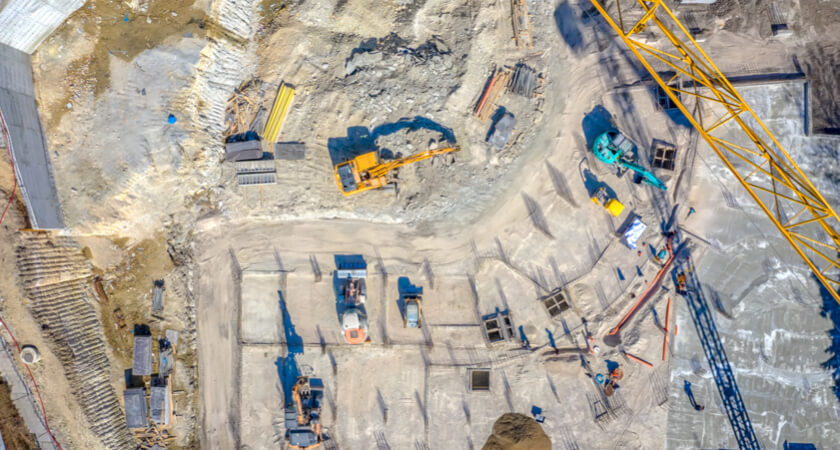
When we talk about stockpiles, what are we really talking about? A pile of any material can easily be measured using a drone. The size of the pile or the number of piles can vary in size depending on the use case, and any pile can be measured accurately. In construction, it’s typical during the earthworks phase to have multiple piles on the job site from material cut away from the site. With mining, inventory management is a major factor in purchasing, selling materials, or understanding value of site currently. And in agriculture, many dairy and beef farms house large stockpiles of silage for feeding animals. The importance of knowing how much silage is still remaining on the pile help calculate when is the right time to purchase/harvest more grass and grain.
Drone stockpile measurement workflow
Let’s take a look at the steps for utilizing drones to measure stockpiles:
- Determining the right hardware
- Creating a mission
- Processing data in DJI Terra
- Analyzing Stockpiles Exporting data
- 3rd Party Solutions
Determining the right hardware
When determining the right drone for measuring stockpiles, there are two major factors: image clarity and data accuracy.
Image clarity can be achieved by a camera with a large sensor, mechanical shutter, high-grade sensor optics, and megapixel count (although it isn’t all about more MP!)
For data accuracy, including a GNSS receiver on the drone greatly improves your precision with more satellites. Also, data processed with RTK can achieve a high level of Absolute Accuracy. This means the data will align near-perfectly over time, very important when flights are conducted over the same piles every time. While the overall location of the stockpile yards and quarry sites rarely changes over time, the piles within the sites are constantly growing and shrinking. Without RTK or GCPs, maps may shift multiple feet, which results in inaccurate measurements of stockpiles when calculating change from two different dates.
Another aspect of determining the right drone is a better understanding of your own site. The site’s size and environment can play into needing a drone with more flight time, higher IP rating, or even swappable payloads for measuring stockpiles in dense vegetation with LiDAR.
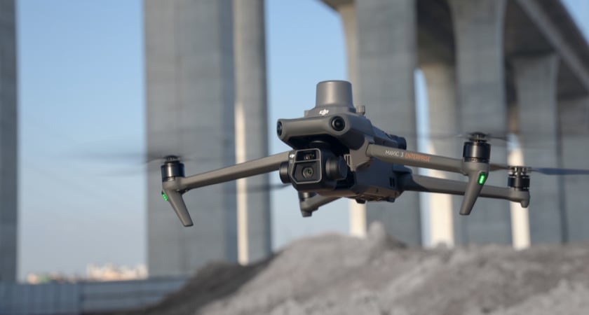
For many clients measuring stockpiles, the industry-leading Mavic 3 Enterprise is the most suitable drone on the market. With a large sensor size of 4/3” and 20MP images, the image quality and clarity for the price is unmatched. And for precision, the Mavic 3 Enterprise has an optional RTK receiver for geotagging imagery more accurately, and a high-quality mechanical shutter to minimize image blur/inaccuracies. The price point for the Mavic 3 Enterprise is also super scalable and affordable for the feature set.
For more difficult or larger sites, the DJI Matrice 350 RTK and Zenmuse P1 is a perfect fit. The P1 boasts a full-frame sensor capturing 45MP imagery. This allows you to fly higher (and in turn, more acres) while maintaining the same Ground Sampling Distance as the Mavic 3 Enterprise. The P1 also utilizes a mechanical shutter for higher levels of accuracy. The Matrice 350 has the ability to swap payloads, so if your site has dense vegetation covering the piles, stockpiles can still be calculated but require LiDAR for higher accuracy. The Zenmuse L1 payload can help you gather accurate point clouds from LiDAR, which can also be used for stockpile measurements. Typically when using lidar for measuring stockpiles with vegetation, a Digital Terrain Model will need to be generated to make measurements from.
Creating a Mission
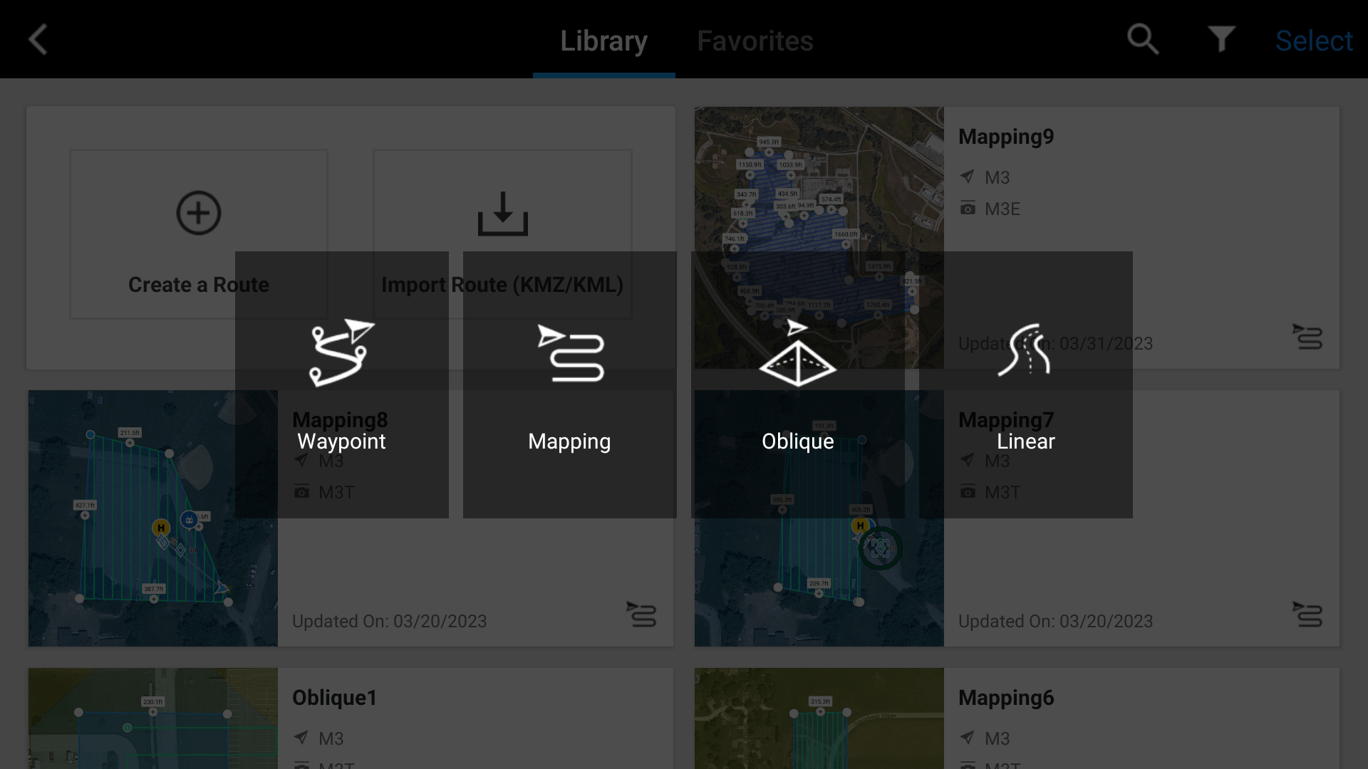
When calculating stockpiles, the recommended procedure for automated flights is to plan a mapping mission. When viewing the DJI Pilot 2 app on your controller, select the Flight Route option on the right side of the screen. Next, Create a Route, and when prompted, select the Mapping option.
Make sure the controller is connected to the internet, and then zoom to your site. Select the Camera, and an automated flight route will generate. Drag the white dots on the border of the polygon to cover the area you would like to fly.
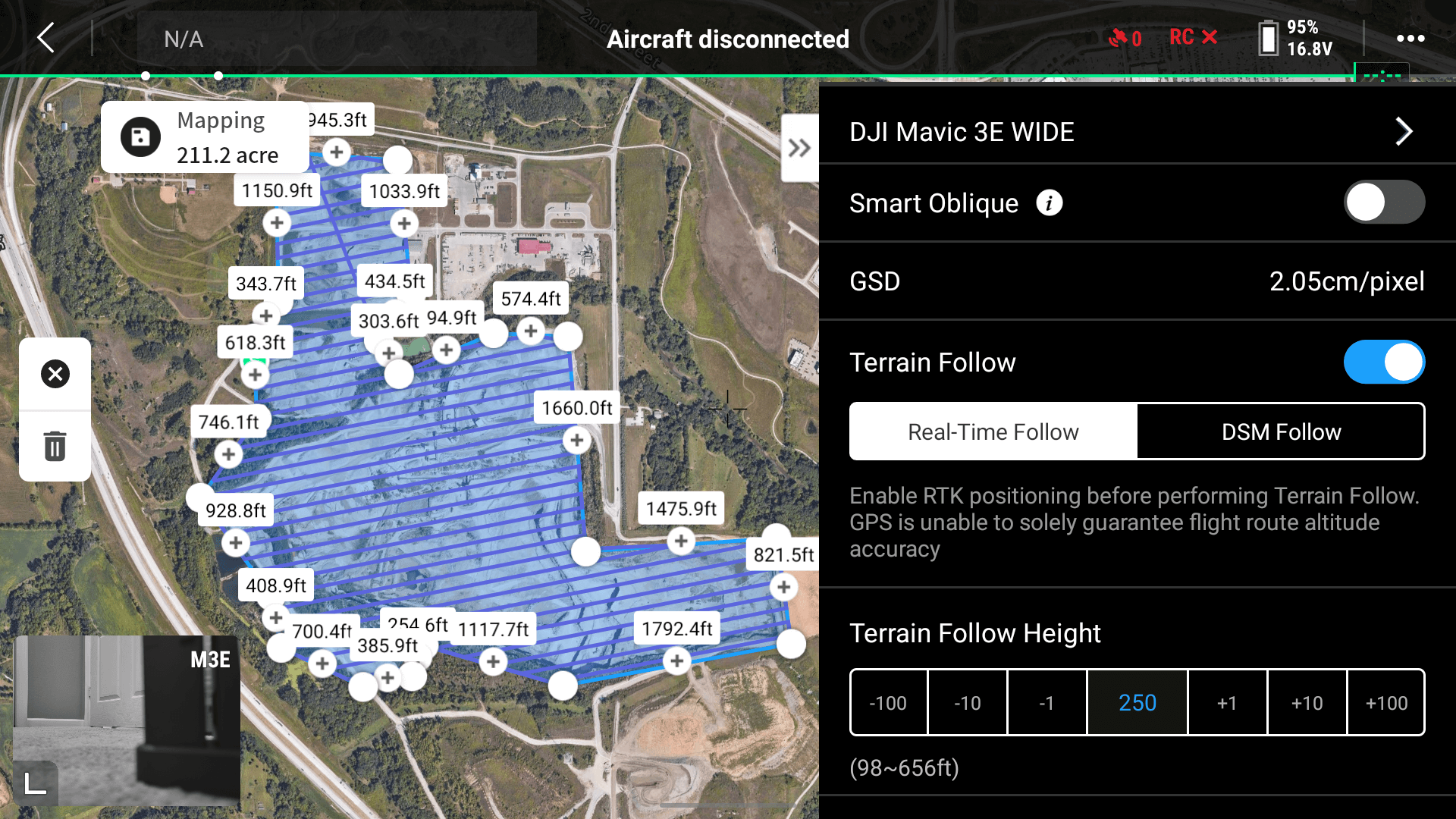
Once you have the polygon ready you’ll need to observe some mission settings. Make sure Smart Oblique is off (stockpile data should only be captured NADIR to ground), but toggle on Terrain Follow if you have large terrain changes. The Mavic 3 Enterprise can utilize the Real-Time Terrain Follow feature, but a DSM import is also supported. For more information on Terrain Following, watch this YouTube video.
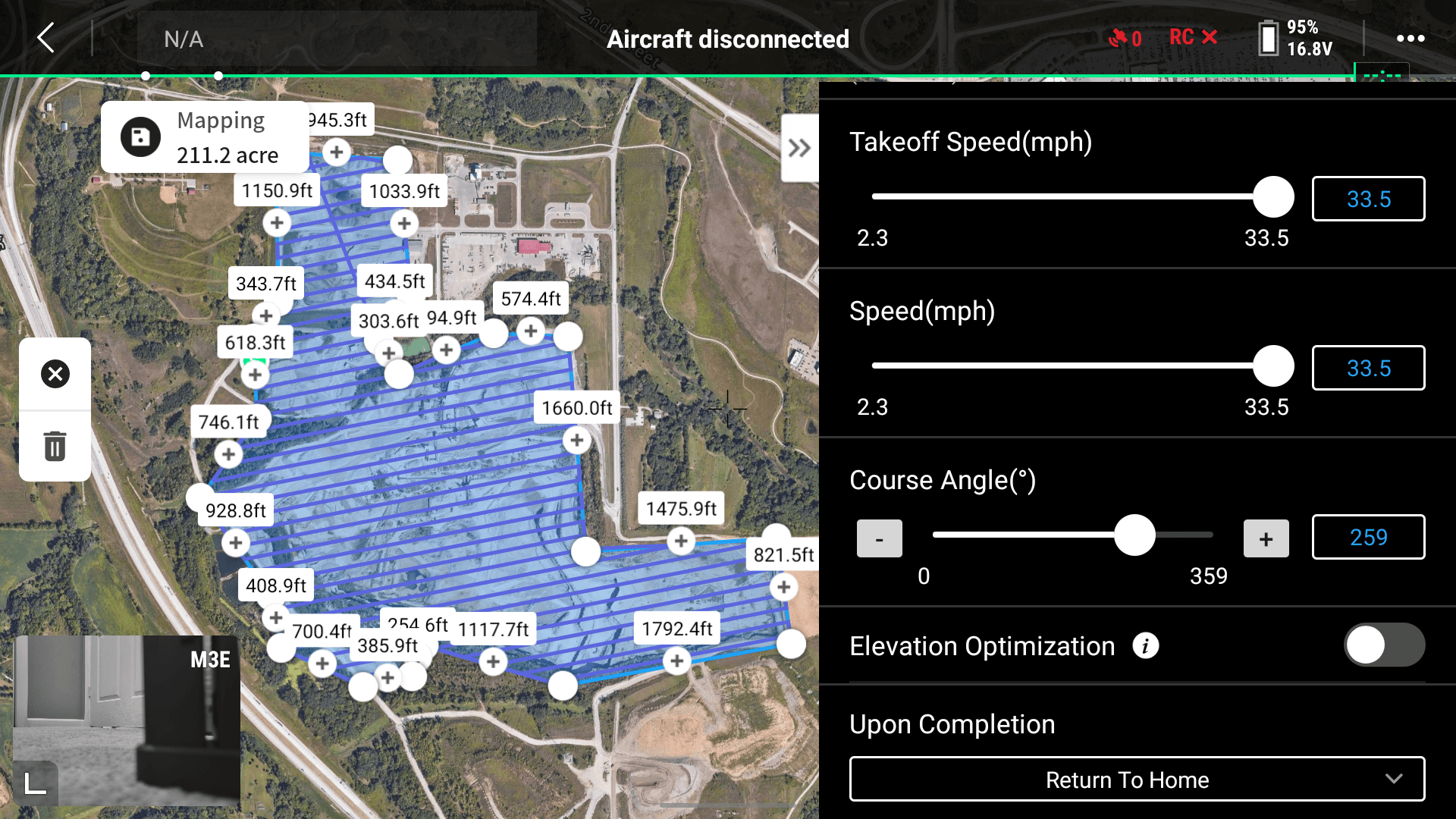
Next, it’s time to set flight altitude. A recommended flight altitude for stockpiles is around 250 feet AGL. Flying any higher hinders the ability to properly tag Ground Control Points (GCPs) or checkpoints, but flying lower increases mission time. The Mavic 3 Enterprise boasts an astounding 42 minutes of flight time with the RTK receiver mounted, so if your site is smaller than 20 acres, feel free to fly lower for higher resolution imagery. Flight speed can be set at max speed (if conditions are safe to do so) thanks to the 0.7-second capture interval and mechanical shutter of our mapping sensors.
Elevation optimization should be turned off. You can capture only NADIR imagery for stockpile analysis.
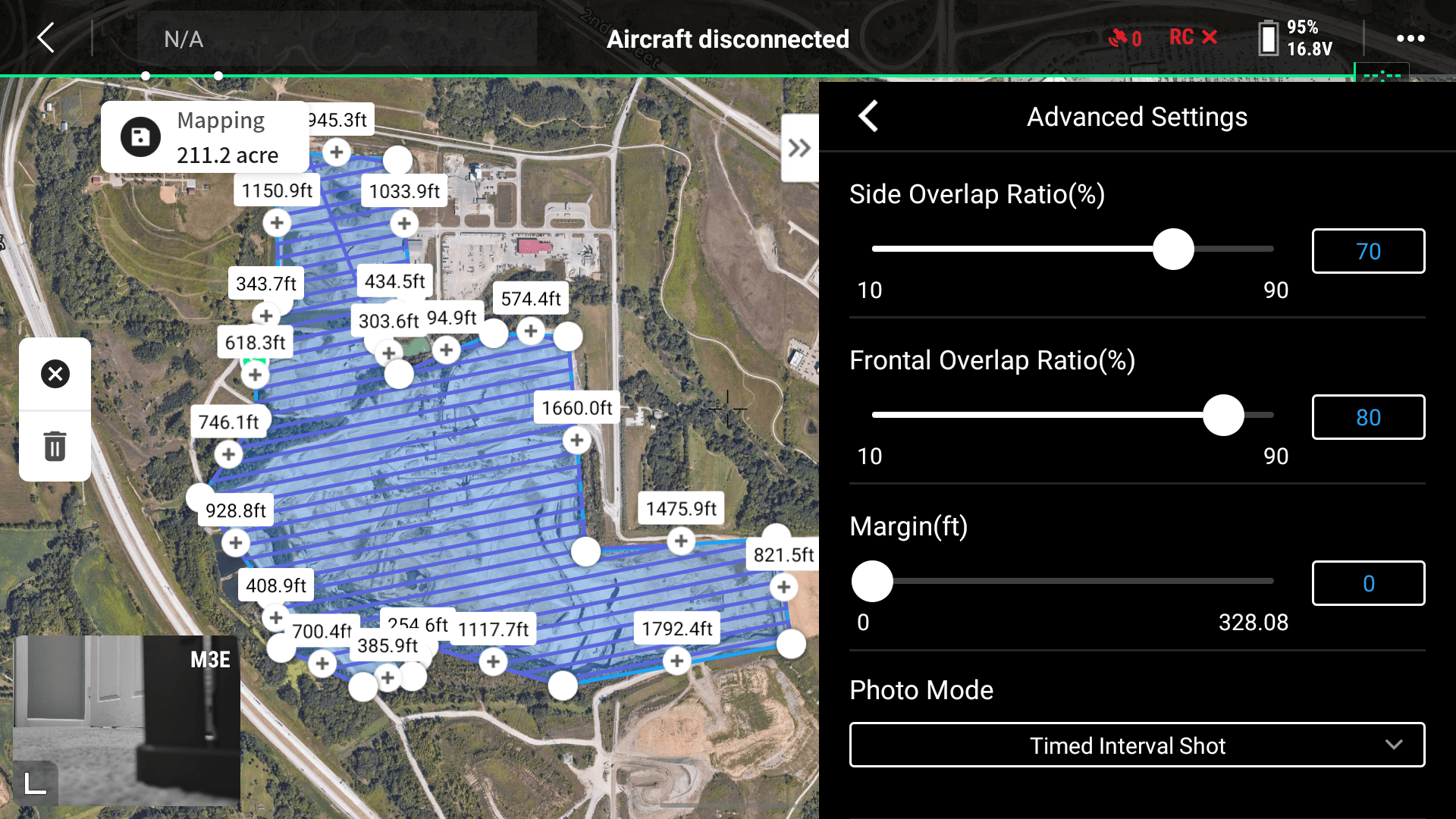
Under the Advanced Settings you can change the Side Overlap and Front Overlap, we recommend leaving the defaults set (70% sidelap and 80% frontlap).
When ready, save the mission, then Play the mission. This will pull up the preflight checklist with the last few mission settings. On the second page, you can see the options for camera settings. For those getting started mapping we recommend using Auto mode. If you are having issues with image brightness or slow shutter speed, you can set the camera to M (Manual) mode, change the shutter speed to 1/1000 minimum, and toggle off Dewarping. By locking the shutter speed at 1/1000 you can minimize motion blur, but if the imagery is too dark adjust the ISO during flight. Now you’re ready to fly!
Processing data in DJI Terra
Once the site has been captured, it’s time to process the data. Remove the micro SD card and insert it into your computer. Launch DJI Terra, DJI’s photogrammetry engine. On the Reconstruction tab, in the bottom left corner, select New Mission. Once Visible Light has been selected the new project has been created.
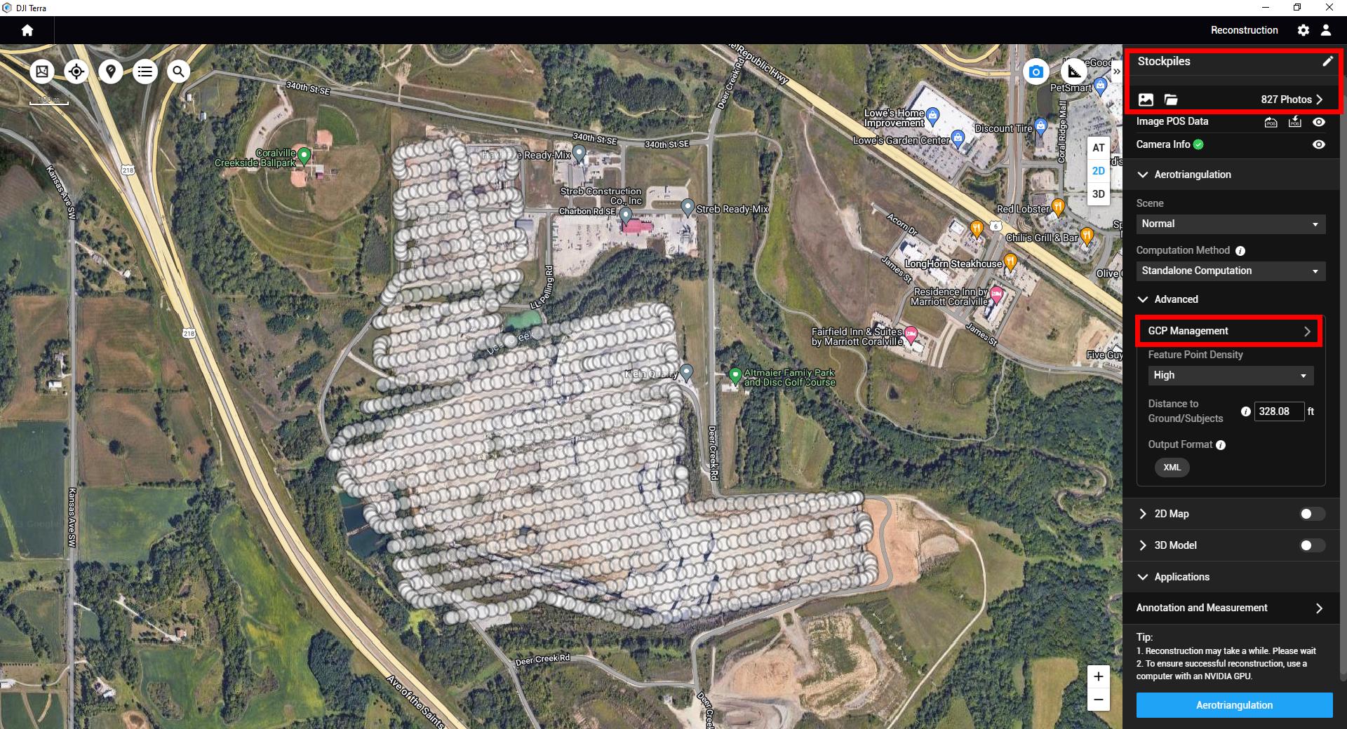
To import the imagery, select the Folder icon (upper right). This will populate image locations of each image. If Ground Control Points or Checkpoints were captured onsite, use the GCP Management tool to help tag the markers. Since Matrice 350 RTK and Mavic 3 Enterprise utilize RTK, no GCPs are required, but Checkpoint targets are always recommended to check against the accuracy of the survey.
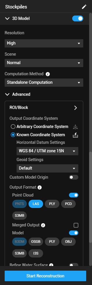
Toggle on 2D Map and 3D Map, and select the specific file types you require to export from each. Then, select Run Reconstruction. Once the data has finished processing, the stockpiles are ready to be measured.
Analyzing stockpiles
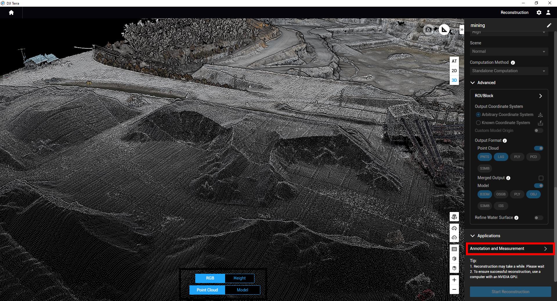
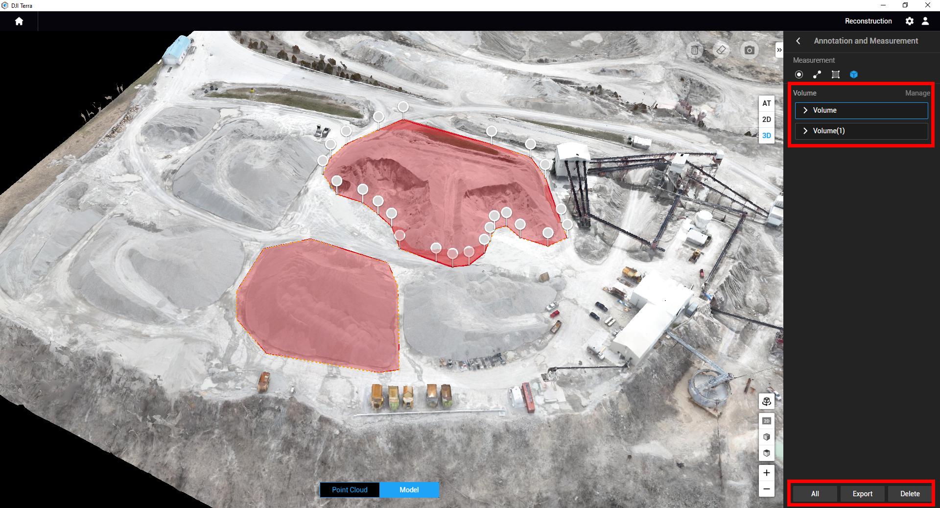
When viewing the map or the model, use the Annotation and Measurement tool in the bottom right corner (you may need to scroll down). DJI Terra’s Annotation and Measurement tools are able to help drop a pin and get coordinates of a location, measure distances across a pile, measure area within a map, or measure volume of a polygon.
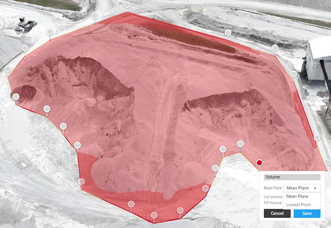
To measure a stockpile, select the Volume tool and click around the stockpile. Once you double click to finish the annotation, Terra will calculate the volume of the pile.
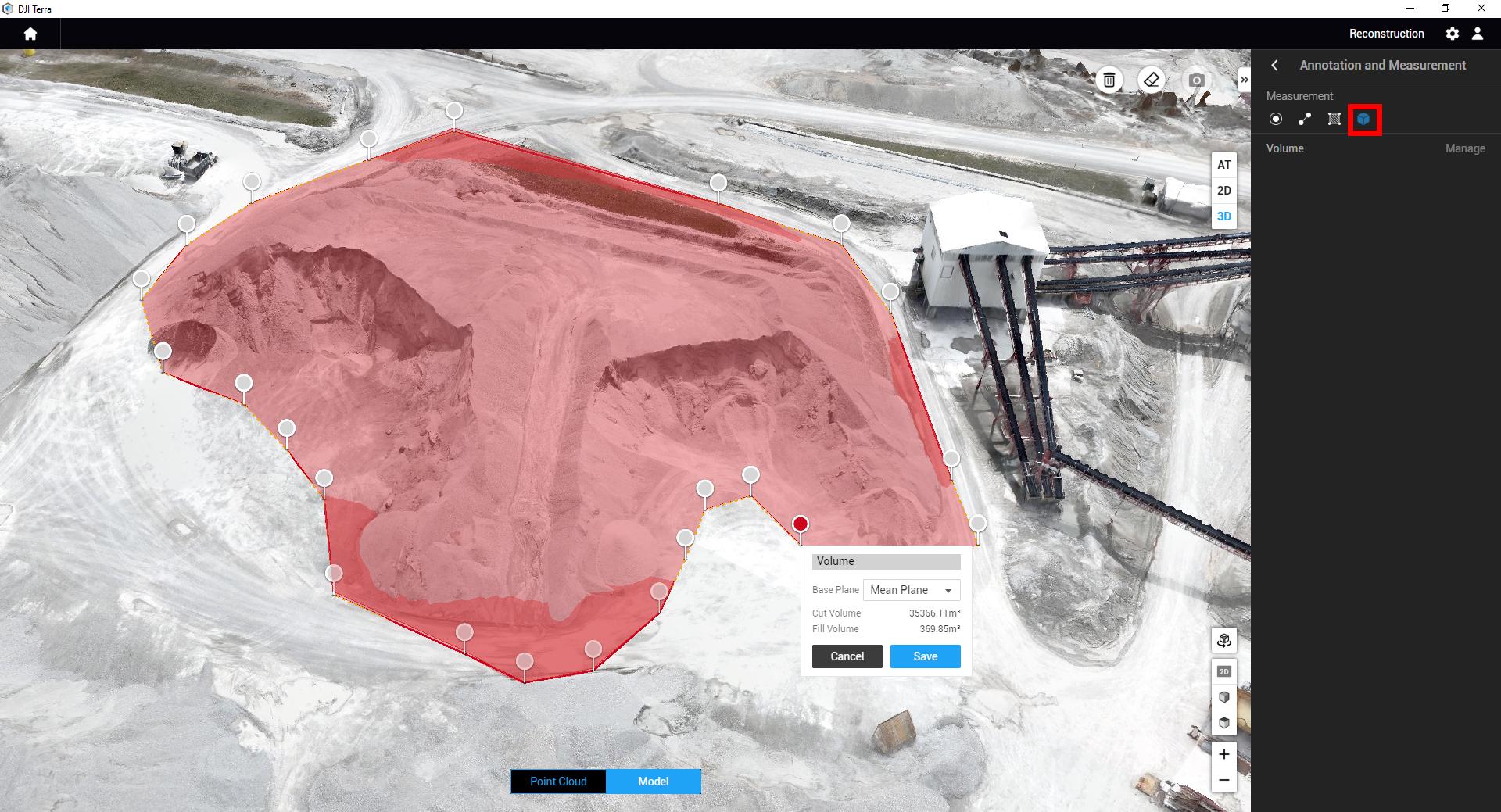
When the pile is calculated, the outputs are in Cut and Fill volumes. You also have the ability to change the Base Plane to one of 2 options:
- Mean Plane: This calculates the bottom of the pile by averaging out the elevation across the annotation. This is the recommended setting for most stockpiles, and is the most accurate for free-standing piles
- Lowest Point: Often stockpiles are contained in bunkers or are pushed against walls. Lowest Point allows the base plane to be measured by the lowest point of elevation in the stockpile, since you can’t measure the back of a bunker.
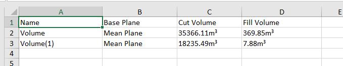
Once the annotation is calculated, you can Save the annotation to keep a record of that specific pile. Annotations can be exported as a single xlsx sheet containing Annotation Name, Base Plane used, Cut and Fill values.
Exporting
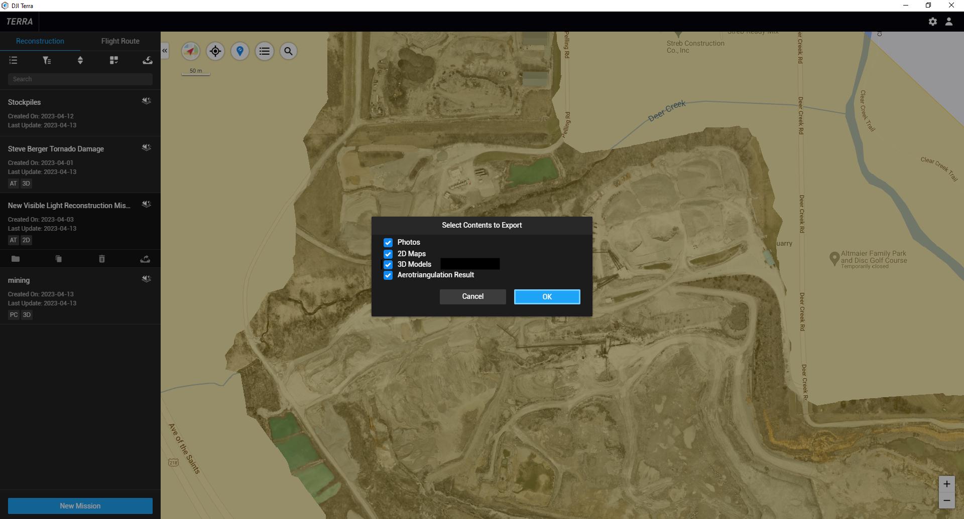
While DJI Terra has the functionality to keep track of stockpiles, often clients prefer the data to be imported into their software platform of choice. When understanding exports, it’s important to know what type of data layer your software of choice supports. For stockpile measures, the most common 2D Export option is a Tiff image. For 3D, most stockpile analysis software utilizes the Point Cloud instead of a 3D mesh, typically in las file format.
To export the map or model, click back to the Home screen and highlight your project. Select the Export option, and choose which data layers you want to export.
3rd party solutions
The most common software of choice for earthworks and stockpile analysis for AEC and Mining users is Trimble Business Center. See our guide on importing data into Trimble Business Center from DJI Terra.
Some other options would be processing the drone data with one of our processing partners. DroneDeploy and Propeller Aero both have robust tools to help measure stockpiles. While these tools typically cost more than Terra, more tools have been added and data is stored in the cloud. One example of DroneDeploy’s Stockpile analysis tools is the ability to measure stockpiles over time, view contour lines, as well as assign material densities and cost.
Thank You for reading! Make sure to subscribe for similar drone content, guides, and more.


-3.png?width=300&name=Insight%20blog%20featured%20image%201140X660%20(2)-3.png)